Ocean Carbon & Biogeochemistry
Studying marine ecosystems and biogeochemical cycles in the face of environmental change
  • Home
  • About OCB
    • About Us
    • Scientific Breadth
      • Biological Pump
      • Changing Marine Ecosystems
      • Changing Ocean Chemistry
      • Estuarine and Coastal Carbon Fluxes
      • Ocean Carbon Uptake and Storage
      • Ocean Observatories
    • Code of Conduct
    • Get Involved
    • Project Office
    • Scientific Steering Committee
    • OCB committees
      • Ocean Time-series
      • US Biogeochemical-Argo
      • Ocean-Atmosphere Interaction
  • Activities
    • Summer Workshop
    • OCB Webinars
    • Guidelines for OCB Workshops & Activities
    • Topical Workshops
      • CMIP6 Models Workshop
      • Coastal BGS Obs with Fisheries
      • C-saw extreme events workshop
      • Expansion of BGC-Argo and Profiling Floats
      • Fish, fisheries and carbon
      • Future BioGeoSCAPES program
      • GO-BCG Scoping Workshop
      • Lateral Carbon Flux in Tidal Wetlands
      • Leaky Deltas Workshop – Spring 2025
      • Marine CDR Workshop
      • Ocean Nucleic Acids ‘Omics
      • Pathways Connecting Climate Changes to the Deep Ocean
    • Small Group Activities
      • Aquatic Continuum OCB-NACP Focus Group
      • Arctic-COLORS Data Synthesis
      • BECS Benthic Ecosystem and Carbon Synthesis WG
      • Carbon Isotopes in the Ocean Workshop
      • CMIP6 WG
      • Filling the gaps air–sea carbon fluxes WG
      • Fish Carbon WG
      • Meta-eukomics WG
      • mCDR
      • Metaproteomic Intercomparison
      • Mixotrophs & Mixotrophy WG
      • N-Fixation WG
      • Ocean Carbonate System Intercomparison Forum
      • Ocean Carbon Uptake WG
      • OOI BGC sensor WG
      • Operational Phytoplankton Observations WG
      • Phytoplankton Taxonomy WG
    • Other Workshops
    • Science Planning
      • Coastal CARbon Synthesis (CCARS)
      • North Atlantic-Arctic
    • Ocean Acidification PI Meetings
    • Training Activities
      • PACE Hackweek 2025
      • PACE Hackweek 2024
      • PACE Training Activity 2022
  • Science Support
    • Data management and archival
    • Early Career
    • Funding Sources
    • Jobs & Postdocs
    • Meeting List
    • OCB Topical Websites
      • Ocean Fertilization
      • Trace gases
      • US IIOE-2
    • Outreach & Education
    • Promoting your science
    • Student Opportunities
    • OCB Activity Proposal Solicitations
      • Guidelines for OCB Workshops & Activities
    • Travel Support
  • Publications
    • OCB Workshop Reports
    • Science Planning and Policy
    • Newsletter Archive
  • Science Highlights
  • News

Want to improve the spatiotemporal coverage of coastal water clarity? This approach combines high-resolution satellite data with low-cost in situ methods

Posted by mmaheigan 
· Friday, December 1st, 2023 

To maintain marine ecosystem health and human well-being, it is important to understand coastal water quality changes. Water clarity is a key­ component of water quality, which can be measured in situ by tools such as Secchi disks or by satellites with high spatial and temporal coverage. Coastal environments pose unique challenges to remote sensing, sometimes resulting in inaccurate estimates of water clarity.
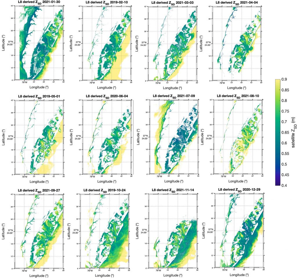
Figure caption: Maps of model-corrected Landsat-8 derived Secchi depths from monthly clear sky images (2019–2021).

In this study, we couple low-cost in situ methods (Secchi disk depths) with open-access, high-resolution satellite (Landsat-8 and Sentinel-2) data to improve estimates of water clarity in a shallow, turbid lagoon in Virginia, USA. Our model allows the retrieval of water clarity data across an entire water body and when field measurements are unavailable. This approach can be implemented in dynamic coastal water bodies with limited in situ measurements (e.g., as part of routine water quality monitoring). This can improve our understanding of water clarity changes and their drivers to better predict how water quality may change in the future. Improved water clarity predictions can lead to better coastal ecosystem management and human well-being.
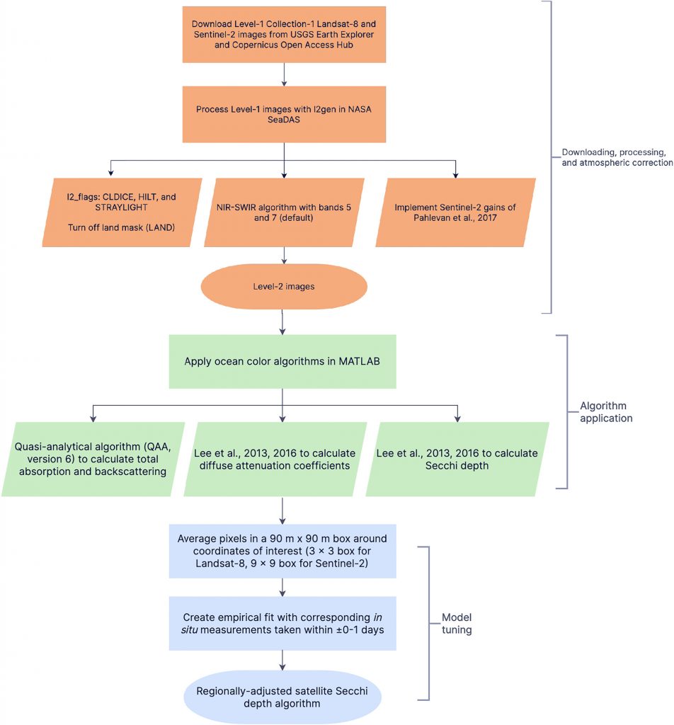
Figure caption: Workflow for obtaining Secchi disk depth with l2gen in NASA SeaDAS, bio-optical algorithms, and empirical adjustments.

Authors
Sarah E. Lang (University of Rhode Island’s Graduate School of Oceanography)
Kelly M.A. Luis (Jet Propulsion Laboratory, California Institute of Technology)
Scott C. Doney (University of Virginia)
Olivia Cronin-Golomb (University of Virginia)
Max C.N. Castorani (University of Virginia)


Twitter / Mastodon
@sarah_langsat8 on Twitter
@kelly_luis1 on Twitter
@scottdoney@universeodon.com on Mastodon
@ocronin_golomb on Twitter
@MaxCastorani on Twitter

Copyright © 2025 - OCB Project Office, Woods Hole Oceanographic Institution, 266 Woods Hole Rd, MS #25, Woods Hole, MA 02543 USA Phone: 508-289-2838  •  Fax: 508-457-2193  •  Email: ocb_news@us-ocb.org

link to nsflink to noaalink to WHOI

Funding for the Ocean Carbon & Biogeochemistry Project Office is provided by the National Science Foundation (NSF) and the National Aeronautics and Space Administration (NASA). The OCB Project Office is housed at the Woods Hole Oceanographic Institution.