Ocean Carbon & Biogeochemistry
Studying marine ecosystems and biogeochemical cycles in the face of environmental change
  • Home
  • About OCB
    • About Us
    • Scientific Breadth
      • Biological Pump
      • Changing Marine Ecosystems
      • Changing Ocean Chemistry
      • Estuarine and Coastal Carbon Fluxes
      • Ocean Carbon Uptake and Storage
      • Ocean Observatories
    • Code of Conduct
    • Get Involved
    • Project Office
    • Scientific Steering Committee
    • OCB committees
      • Ocean Time-series
      • US Biogeochemical-Argo
      • Ocean-Atmosphere Interaction
  • Activities
    • Summer Workshop
    • OCB Webinars
    • Guidelines for OCB Workshops & Activities
    • Topical Workshops
      • CMIP6 Models Workshop
      • Coastal BGS Obs with Fisheries
      • C-saw extreme events workshop
      • Expansion of BGC-Argo and Profiling Floats
      • Fish, fisheries and carbon
      • Future BioGeoSCAPES program
      • GO-BCG Scoping Workshop
      • Lateral Carbon Flux in Tidal Wetlands
      • Leaky Deltas Workshop – Spring 2025
      • Marine CDR Workshop
      • Ocean Nucleic Acids ‘Omics
      • Pathways Connecting Climate Changes to the Deep Ocean
    • Small Group Activities
      • Aquatic Continuum OCB-NACP Focus Group
      • Arctic-COLORS Data Synthesis
      • BECS Benthic Ecosystem and Carbon Synthesis WG
      • Carbon Isotopes in the Ocean Workshop
      • CMIP6 WG
      • Filling the gaps air–sea carbon fluxes WG
      • Fish Carbon WG
      • Meta-eukomics WG
      • mCDR
      • Metaproteomic Intercomparison
      • Mixotrophs & Mixotrophy WG
      • N-Fixation WG
      • Ocean Carbonate System Intercomparison Forum
      • Ocean Carbon Uptake WG
      • OOI BGC sensor WG
      • Operational Phytoplankton Observations WG
      • Phytoplankton Taxonomy WG
    • Other Workshops
    • Science Planning
      • Coastal CARbon Synthesis (CCARS)
      • North Atlantic-Arctic
    • Ocean Acidification PI Meetings
    • Training Activities
      • PACE Hackweek 2025
      • PACE Hackweek 2024
      • PACE Training Activity 2022
  • Science Support
    • Data management and archival
    • Early Career
    • Funding Sources
    • Jobs & Postdocs
    • Meeting List
    • OCB Topical Websites
      • Ocean Fertilization
      • Trace gases
      • US IIOE-2
    • Outreach & Education
    • Promoting your science
    • Student Opportunities
    • OCB Activity Proposal Solicitations
      • Guidelines for OCB Workshops & Activities
    • Travel Support
  • Publications
    • OCB Workshop Reports
    • Science Planning and Policy
    • Newsletter Archive
  • Science Highlights
  • News

Archive for global ocean

Swirling Currents: How Ocean Mesoscale Affects Air-Sea CO2 Exchange

Posted by mmaheigan 
· Friday, October 25th, 2024 

Due to a sparsity of in‐situ observations and the computational burden of eddy‐resolving global simulations, there has been little analysis on how mesoscale processes (e.g., eddies, meanders—lateral scales of 10s to 100s km) influence air‐sea CO2 fluxes from a global perspective. Recently, it became computationally feasible to implement global eddy‐resolving [O (10) km] ocean biogeochemical models. Many questions related to the influence of mesoscale motions on CO2 fluxes remain open, including whether ocean eddies serve as hotspots for CO2 sink or source in specific dynamic regions.

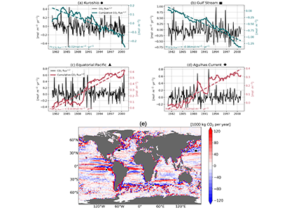
A recent study in Geophysical Research Letters investigated the contribution of ocean mesoscale variability to air-sea CO2 fluxes by analyzing the CO2 flux anomaly within the mesoscale band using a coarse-graining approach in a global eddy-resolving biogeochemical simulation. We found that in eddy-rich mid-latitude regions, ocean mesoscale variability can contribute to over 30% of the total CO2 flux variability. The cumulative net CO2 flux associated with mesoscale motions is on the order of 105 tC per year. The global pattern of cumulative mesoscale-related CO2 flux exhibits significant spatial heterogeneity, with the highest values in western boundary currents, the Antarctic Circumpolar Current, and the equatorial Pacific. The local distribution of cumulative mesoscale-related CO2 flux displays zonal bands alternate between positive (a net source) and negative (a net sink) due to the meandering nature of ocean mesoscale currents, which is related to local relative vorticity and the background cross-stream pCO2 gradient.

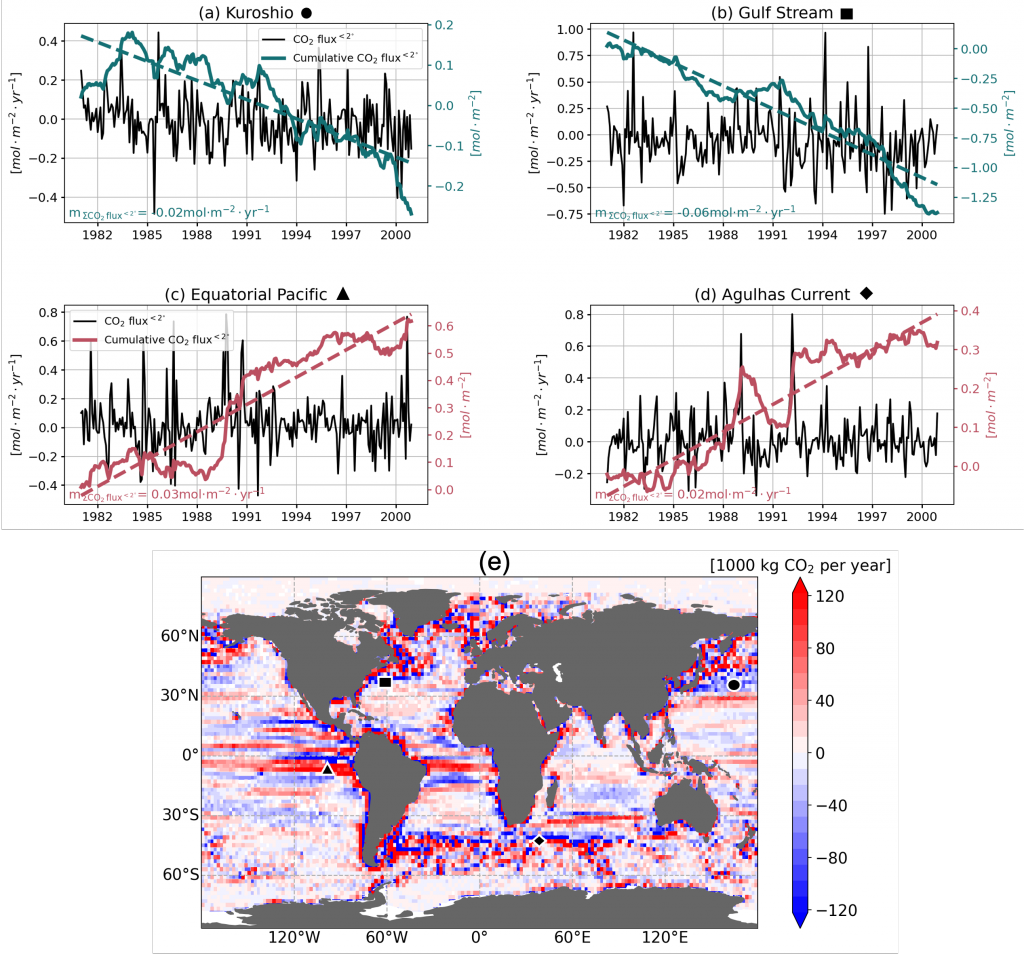
Figure caption. Mesoscale (<nominal 2 degree) contribution to air‐sea CO2 flux (F<2°CO2)in the model. (a)–(d) Monthly time series of F<2°CO2 (black lines) and cumulative F<2°CO2 (green/red solid lines) in four locations marked in (e). Dashed lines are the least squares regression of cumulative flux for the period 1982–2000; slopes are indicated in the bottom left; (e) Blue colors imply a CO₂ sink, and red colors represent a source. The figure shows the global distribution of the regressed slopes of cumulative F<2°CO2. Units are converted from mol m-2 per year to kg of CO2 per year using the atomic mass of CO2. This figure shows significant spatial heterogeneity of mesoscale-modulated CO2 flux, showing contributions to both CO₂ sources and sinks across different regions of the ocean, with a magnitude on the order of 105 tC per year.


Authors
Yiming Guo (Yale University; now at Woods Hole Oceanographic Institution)
Mary-Louise Timmermans (Yale University)

Fishing Vessel Ocean Observing Network (FVON) reimagines the global data collection paradigm

Posted by mmaheigan 
· Friday, December 1st, 2023 

With an increasingly wide variety of technology and innovations, from buoys to satellites, we now understand the open ocea n better than ever. Yet, existing technologies cannot cost-effectively provide accurate, up-to-date data on coastal and shelf ocean environments, especially beneath the surface. These dynamic regions impact billions of people in profound and varied ways.

Figure caption: Alongside other major global ocean observing technologies and networks, the Fishing Vessel Ocean Observing Network is built around the concept of “fishing for data” to collect high-quality ocean data such as temperature and salinity profiles. These measurements inform critical policy decisions, are integrated into sustainability efforts for fishers, scientists, and other relevant stakeholders, and can improve climate resiliency while protecting the health, well-being, and livelihoods of coastal communities and participants in the blue economy.

As described in a recent publication, the Fishing Vessel Ocean Observing Network (FVON) is reimagining the global data collection paradigm of coastal and shelf oceans by partnering with fishers and regional observation networks around the world. With more than four million fishing vessels worldwide, fishers cover much of the data-sparse nearshore ocean environments, vitally important regions of the ocean. By outfitting sensors onto vessels and on fishing gear, programs from New Zealand to Japan to New England, including researchers at WHOI, demonstrate that fishers can participate actively in the ongoing data revolution and eliminate critical oceanic data gaps without changing their standard fishing activities. Exponentially increasing the scale of data collection through fishing vessel and gear-based observations in nearshore marine environments has and will continue to democratize ocean observation, improve weather forecasting and ocean monitoring, and promote sustainable fishing while safeguarding lives and livelihoods. Already a proven concept regionally, FVON, alongside fishers and regional observation networks, will expand fishing-based observation to a global initiative.


Authors
Cooper Van Vranken (Ocean Data Network)
Julie Jakoboski (MetOcean Solutions, New Zealand)
John W. Carroll (Ocean Data Network)
Christopher Cusack (Environmental Defense Fund)
Patrick Gorringe (Swedish Meteorological and Hydrological Institute)
Naoki Hirose (Kyushu University, Japan)
James Manning (NOAA Northeast Fisheries Science Center (retired))
Michela Martinelli (National Research Council−Institute of Marine Biological Resources and Biotechnologies, Italy)
Pierluigi Penna (National Research Council−Institute of Marine Biological Resources and Biotechnologies, Italy)
Mathew Pickering (Environmental Defense Fund)
A. Miguel Piecho-Santos (Portuguese Institute for Sea and Atmosphere)
Moninya Roughan (University of New South Wales, Australia)
João de Souza (MetOcean Solutions, New Zealand)
Hassan Moustahfid (NOAA Integrated Ocean Observing System (IOOS))

Integrated analysis of carbon dioxide and oxygen concentrations as a quality control of ocean float data

Posted by mmaheigan 
· Friday, August 26th, 2022 

A recent study in Communications Earth & Environment, examined spatiotemporal patterns of the two dissolved gases CO2 and O2 in the surface ocean, using the high-quality global dataset GLODAPv2.2020. We used surface ocean data from GLODAP to make plots of carbon dioxide and oxygen relative to saturation (CORS plots). These plots of CO2 deviations from saturation (ΔCO2) against oxygen deviations from saturation (ΔO2) (Figure 1) provide detailed insight into the identity and intensity of biogeochemical processes operating in different basins.

Figure 1: Relationships between ΔCO2 and ΔO2 in the global ocean basins based on surface data in the GLODAPv2.2020 database. The black dashed lines are the least-squares best-fit lines to the data; unc denotes the uncertainty in the y-intercept value with 95% confidence; r is the associated Pearson correlation coefficient; n is the number of data points.

In addition, data in all basins and all seasons shares some common behaviors: (1) negative slopes of best fit lines to the data, and (2) near-zero y-intercepts of those lines. We utilized these findings to compare patterns in CORS plots from GLODAP with those from BGC-Argo float data from the Southern Ocean Carbon and Climate Observations and Modeling (SOCCOM) program. Given that the float O2 data is likely to be more accurate than the float pH data (from which the float CO2 is calculated), CORS plots are useful for detecting questionable float CO2 data, by comparing trends in float CORS plots (e.g. Figure 2) to trends in GLODAP CORS plots (Figure 1). As well as the immediately detected erroneous data, we discovered significant discrepancies in ΔCO2-ΔO2 y-intercepts compared to the global reference (i.e., GLODAPv2.2020 y-intercepts, Figure 1). The y-intercepts of 48 floats with QCed O2 and CO2 data (at regions south of 55°S) were on average greater by 0.36 μmol kg−1 than the GLODAP-derived ones, implying the overestimations of float-based CO2 release in the Southern Ocean.

Figure 2. CORS plots from data collected by SOCCOM floats F9096 and F9099 in the high-latitude Southern Ocean. Circles with solid edges denote data flagged as ‘good’, whereas crosses denote data flagged as ‘questionable’.

Our study demonstrates CORS plots’ ability to identify questionable data (data shown to be questionable by other QC methods) and to reveal issues with supposed ‘good’ data (i.e., quality issues not picked up by other QC methods). CORS plots use only surface data, hence this QC method complements existing methods based on analysis of deep data. As the oceanographic community becomes increasingly reliant on data collected from autonomous platforms, techniques like CORS will help diagnose data quality, and immediately detect questionable data.


Authors:
Yingxu Wu (Polar and Marine Research Institute, Jimei University, Xiamen, China; University of Southampton)
Dorothee C.E. Bakker (University of East Anglia)
Eric P. Achterberg (GEOMAR Helmholtz Centre for Ocean Research Kiel)
Amavi N. Silva (University of Southampton)
Daisy D. Pickup (University of Southampton)
Xiang Li (George Washington University)
Sue Hartman (National Oceanography Centre, Southampton)
David Stappard (University of Southampton)
Di Qi (Polar and Marine Research Institute, Jimei University, Xiamen, China)
Toby Tyrrell (University of Southampton)

New Data Standard for Oceanographic Research

Posted by mmaheigan 
· Friday, February 18th, 2022 

Effective data management is paramount in oceanographic research. The ocean is a global system, and research to understand regional and global oceanographic processes often involves compiling cruise-based data from different laboratories and expeditions.

The new international data standard covers column header abbreviations, quality control flags, missing value indicators, and standardized calculation of numerous parameters. Released alongside this paper are newly developed tools to calculate some oceanographic properties, and recommendations for dissociation constants of the seawater carbon system calculations. In addition, the use of “content” instead of “concentration” is recommended for mass-based properties.

Image of CTD alongside ship held by two people with ropes

The column header abbreviation standards presented here are based on the 30-year-old Exchange format of the World Ocean Circulation Experiment (WOCE) Hydrographic Program (Joyce and Corry, 1994; Swift and Diggs, 2008) with updates and refinements by the Climate and Ocean-Variability, Predictability, and Change (CLIVAR) and the Carbon Hydrographic Data Office (CCHDO) of the Scripps Institution of Oceanography. This format has been used as a data file standard for discrete chemical oceanographic observations for several decades.

The new international data standards will facilitate data sharing, quality control, and synthesis efforts to promote climate change and ocean acidification research at regional to global scales. This product is a significant step forward in terms of (a) creating common data standards for the international oceanographic research community to streamline data management, quality control, and data product developments; and (b) bringing the subject matter expertise from the research community to the data management world.


Authors (partial, see full list on publication)
Li-Qing Jiang (Univ Maryland, NOAA/NCEI)
Denis Pierrot (NOAA/AOML)
Rik Wanninkhof (NOAA/AOML)
Richard A. Feely (NOAA/PMEL)
Bronte Tilbrook (CSIRO Oceans and Atmosphere and Australian Antarctic Program Partnership)
Simone Alin (NOAA/AOML)
Leticia Barbero (Univ Miami; NOAA/AOML),
Robert H. Byrne (Univ South Florida),
Brendan R. Carter (Univ Washington, NOAA/PMEL)
Andrew G. Dickson (Scripps Institution of Oceanography)
Jean-Pierre Gattuso (CNRS, Laboratoire d’Océanographie de Villefranche, Sorbonne Univ; Institute for Sustainable Development and International Relations, Sciences Po, France)
Dana Greeley (NOAA/PMEL)
Mario Hoppema (Alfred Wegener Institute Helmholtz Centre for Polar and Marine Research, Sciences Po,)
Matthew P. Humphreys (NIOZ Royal Netherlands Institute for Sea Research, Netherlands)
Johannes Karstensen (GEOMAR Helmholtz Centre for Ocean Research Kiel, Germany)
et al.


Filter by Keyword

abundance acidification additionality advection africa air-sea air-sea interactions algae alkalinity allometry ammonium AMO AMOC anoxic Antarctic Antarctica anthro impacts anthropogenic carbon anthropogenic impacts appendicularia aquaculture aquatic continuum aragonite saturation arctic Argo argon arsenic artificial seawater Atlantic atmospheric CO2 atmospheric nitrogen deposition authigenic carbonates autonomous platforms bacteria bathypelagic BATS BCG Argo benthic bgc argo bio-go-ship bio-optical bioavailability biogeochemical cycles biogeochemical models biogeochemistry Biological Essential Ocean Variables biological pump biophysics bloom blue carbon bottom water boundary layer buffer capacity C14 CaCO3 calcification calcite carbon carbon-climate feedback carbon-sulfur coupling carbonate carbonate system carbon budget carbon cycle carbon dioxide carbon export carbon fluxes carbon sequestration carbon storage Caribbean CCA CCS changing marine chemistry changing marine ecosystems changing marine environments changing ocean chemistry chemical oceanographic data chemical speciation chemoautotroph chesapeake bay chl a chlorophyll circulation CO2 coastal and estuarine coastal darkening coastal ocean cobalt Coccolithophores commercial community composition competition conservation cooling effect copepod copepods coral reefs CTD currents cyclone daily cycles data data access data assimilation database data management data product Data standards DCM dead zone decadal trends decomposers decomposition deep convection deep ocean deep sea coral denitrification deoxygenation depth diatoms DIC diel migration diffusion dimethylsulfide dinoflagellate dinoflagellates discrete measurements distribution DOC DOM domoic acid DOP dust DVM ecology economics ecosystem management ecosystems eddy Education EEZ Ekman transport emissions ENSO enzyme equatorial current equatorial regions ESM estuarine and coastal carbon fluxes estuary euphotic zone eutrophication evolution export export fluxes export production extreme events faecal pellets fecal pellets filter feeders filtration rates fire fish Fish carbon fisheries fishing floats fluid dynamics fluorescence food webs forage fish forams freshening freshwater frontal zone functional role future oceans gelatinous zooplankton geochemistry geoengineering geologic time GEOTRACES glaciers gliders global carbon budget global ocean global warming go-ship grazing greenhouse gas greenhouse gases Greenland ground truthing groundwater Gulf of Maine Gulf of Mexico Gulf Stream gyre harmful algal bloom high latitude human food human impact human well-being hurricane hydrogen hydrothermal hypoxia ice age ice cores ice cover industrial onset inland waters in situ inverse circulation ions iron iron fertilization iron limitation isotopes jellies katabatic winds kelvin waves krill kuroshio lab vs field land-ocean continuum larvaceans lateral transport LGM lidar ligands light light attenuation lipids low nutrient machine learning mangroves marine carbon cycle marine heatwave marine particles marine snowfall marshes mCDR mechanisms Mediterranean meltwater mesopelagic mesoscale mesoscale processes metagenome metals methane methods microbes microlayer microorganisms microplankton microscale microzooplankton midwater mitigation mixed layer mixed layers mixing mixotrophs mixotrophy model modeling model validation mode water molecular diffusion MPT MRV multi-decade n2o NAAMES NCP nearshore net community production net primary productivity new ocean state new technology Niskin bottle nitrate nitrogen nitrogen cycle nitrogen fixation nitrous oxide north atlantic north pacific North Sea nuclear war nutricline nutrient budget nutrient cycles nutrient cycling nutrient limitation nutrients OA observations ocean-atmosphere ocean acidification ocean acidification data ocean alkalinity enhancement ocean carbon storage and uptake ocean carbon uptake and storage ocean color ocean modeling ocean observatories ocean warming ODZ oligotrophic omics OMZ open ocean optics organic particles oscillation outwelling overturning circulation oxygen pacific paleoceanography PAR parameter optimization parasite particle flux particles partnerships pCO2 PDO peat pelagic PETM pH phenology phosphate phosphorus photosynthesis physical processes physiology phytoplankton PIC piezophilic piezotolerant plankton POC polar polar regions policy pollutants precipitation predation predator-prey prediction pressure primary productivity Prochlorococcus productivity prokaryotes proteins pteropods pycnocline radioisotopes remineralization remote sensing repeat hydrography residence time resource management respiration resuspension rivers rocky shore Rossby waves Ross Sea ROV salinity salt marsh satellite scale seafloor seagrass sea ice sea level rise seasonal seasonality seasonal patterns seasonal trends sea spray seawater collection seaweed secchi sediments sensors sequestration shelf ocean shelf system shells ship-based observations shorelines siderophore silica silicate silicon cycle sinking sinking particles size SOCCOM soil carbon southern ocean south pacific spatial covariations speciation SST state estimation stoichiometry subduction submesoscale subpolar subtropical sulfate surf surface surface ocean Synechococcus technology teleconnections temperate temperature temporal covariations thermocline thermodynamics thermohaline thorium tidal time-series time of emergence titration top predators total alkalinity trace elements trace metals trait-based transfer efficiency transient features trawling Tris trophic transfer tropical turbulence twilight zone upper ocean upper water column upwelling US CLIVAR validation velocity gradient ventilation vertical flux vertical migration vertical transport warming water clarity water mass water quality waves weathering western boundary currents wetlands winter mixing zooplankton

Copyright © 2025 - OCB Project Office, Woods Hole Oceanographic Institution, 266 Woods Hole Rd, MS #25, Woods Hole, MA 02543 USA Phone: 508-289-2838  •  Fax: 508-457-2193  •  Email: ocb_news@us-ocb.org

link to nsflink to noaalink to WHOI

Funding for the Ocean Carbon & Biogeochemistry Project Office is provided by the National Science Foundation (NSF) and the National Aeronautics and Space Administration (NASA). The OCB Project Office is housed at the Woods Hole Oceanographic Institution.