Ocean Carbon & Biogeochemistry
Studying marine ecosystems and biogeochemical cycles in the face of environmental change
  • Home
  • About OCB
    • About Us
    • Scientific Breadth
      • Biological Pump
      • Changing Marine Ecosystems
      • Changing Ocean Chemistry
      • Estuarine and Coastal Carbon Fluxes
      • Ocean Carbon Uptake and Storage
      • Ocean Observatories
    • Code of Conduct
    • Get Involved
    • Project Office
    • Scientific Steering Committee
    • OCB committees
      • Ocean Time-series
      • US Biogeochemical-Argo
      • Ocean-Atmosphere Interaction
  • Activities
    • Summer Workshop
    • OCB Webinars
    • Guidelines for OCB Workshops & Activities
    • Topical Workshops
      • CMIP6 Models Workshop
      • Coastal BGS Obs with Fisheries
      • C-saw extreme events workshop
      • Ecological Forecasting – North American Coastlines
      • Expansion of BGC-Argo and Profiling Floats
      • Fish, fisheries and carbon
      • Future BioGeoSCAPES program
      • GO-BCG Scoping Workshop
      • Lateral Carbon Flux in Tidal Wetlands
      • Marine CDR Workshop
      • Ocean Nucleic Acids ‘Omics
      • Ocean-Atmosphere Interactions
      • Oceanic Methane & Nitrous Oxide
    • Small Group Activities
      • Aquatic Continuum OCB-NACP Focus Group
      • Arctic-COLORS Data Synthesis
      • BECS Benthic Ecosystem and Carbon Synthesis WG
      • Carbon Isotopes in the Ocean Workshop
      • CMIP6 WG
      • Filling the gaps air–sea carbon fluxes WG
      • Fish Carbon WG
        • Fish Carbon WG Workshop
        • Fish carbon workshop summary
      • Marine carbon dioxide removal
      • Metaproteomic Intercomparison
      • Mixotrophs & Mixotrophy WG
      • N-Fixation WG
      • Ocean Carbonate System Intercomparison Forum
      • Ocean Carbon Uptake WG
      • OOI BGC sensor WG
      • Operational Phytoplankton Observations WG
      • Phytoplankton Taxonomy WG
    • Other Workshops
    • Science Planning
      • Coastal CARbon Synthesis (CCARS)
      • North Atlantic-Arctic
    • Ocean Acidification PI Meetings
    • Training Activities
      • PACE Training Activity
  • Science Support
    • Data management and archival
    • Early Career
    • Funding Sources
    • Jobs & Postdocs
    • Meeting List
    • OCB Topical Websites
      • Ocean Fertilization
      • Trace gases
      • US IIOE-2
    • Outreach & Education
    • Promoting your science
    • Student Opportunities
    • OCB Activity Proposal Solicitations
      • Guidelines for OCB Workshops & Activities
    • Travel Support
  • Publications
    • Ocean Carbon Exchange
    • OCB Workshop Reports
    • Science Planning and Policy
    • Newsletter Archive
  • OCB Science Highlights
  • News

Archive for ocean color

Profiling floats reveal fate of Southern Ocean phytoplankton stocks

Posted by mmaheigan 
· Tuesday, September 1st, 2020 

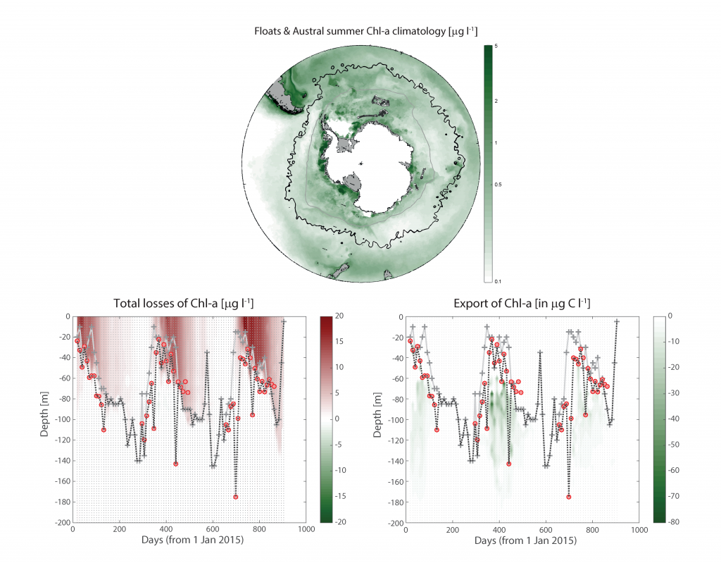
More observations are needed to constrain the relative roles of physical (advection), biogeochemical (downward export), and ecological (grazing and biological losses) processes in driving the fate of phytoplankton blooms in Southern Ocean waters. In a recent paper published in Nature Communications, authors used seven Biogeochemical Argo (BGC-Argo) floats that vertically profiled the upper ocean every ten days as they drifted for three years across the remote Sea Ice Zone of the Southern Ocean. Using the floats’ biogeochemical sensors (chlorophyll, nitrate, and backscattering) and regional ratios of nitrate consumption:chlorophyll synthesis, the authors developed a new approach to remotely estimate the fate of the phytoplankton stocks, enabling calculations of herbivory and of downward carbon export. The study revealed that the major fate of phytoplankton biomass in this region is grazing, which consumes ~90% of stocks. The remaining 10% is exported to depth. This pattern was consistent throughout the entire sea ice zone where the floats drifted, from 60°-69° South.

Figure Caption: Southern Ocean Chlorophyll a climatology and floats’ trajectories (top panel). Total losses of Chlorophyll a (including grazing and phytodetritus export, left panel). Phytodetritus export (right panel).


This study region comprises two of the three major krill growth and development areas—the eastern Weddell and King Haakon VII Seas and Prydz Bay and the Kerguelen Plateau—so the observed grazing was probably due to Antarctic krill, underscoring their pivotal importance in this ecosystem. Building upon the greater understanding of ocean ecosystems via satellite ocean colour development in the 1990s, BGC-Argo floats and this new approach will allow remote monitoring of the different fates of phytoplankton stocks and insights into the status of the ecosystem.


Authors:
Sebastien Moreau (Norwegian Polar Institute, Tromsø, Norway)
Philip Boyd (Institute for Marine and Antarctic Studies, Hobart, Australia)
Peter Strutton (Institute for Marine and Antarctic Studies, Hobart, Australia)

A new tidal non-photochemical quenching model reveals obscured variability in coastal chlorophyll fluorescence

Posted by mmaheigan 
· Tuesday, October 15th, 2019 

Although chlorophyll fluorescence is widely-used as a proxy for chlorophyll concentration, sunlight exposure makes fluorescence measurements inaccurate through a process called non-photochemical quenching, limiting its proxy accuracy during daylight hours. In the open ocean, where time and space scales are large relative to variability in phytoplankton concentration, daytime chlorophyll fluorescence—necessary for satellite algorithm validation and for understanding diurnal variability in phytoplankton abundance—can be estimated by averaging across successive nighttime, unquenched values. In coastal waters, where semidiurnal tidal advection drives small scale patchiness and short temporal variability, successive nighttime observations do not accurately represent the intervening daytime. Thus, it is necessary to apply a non-photochemical quenching correction that accounts for the additional effect of tidal advection.

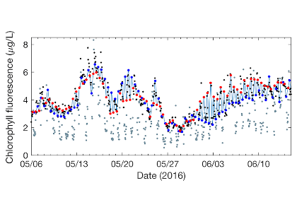
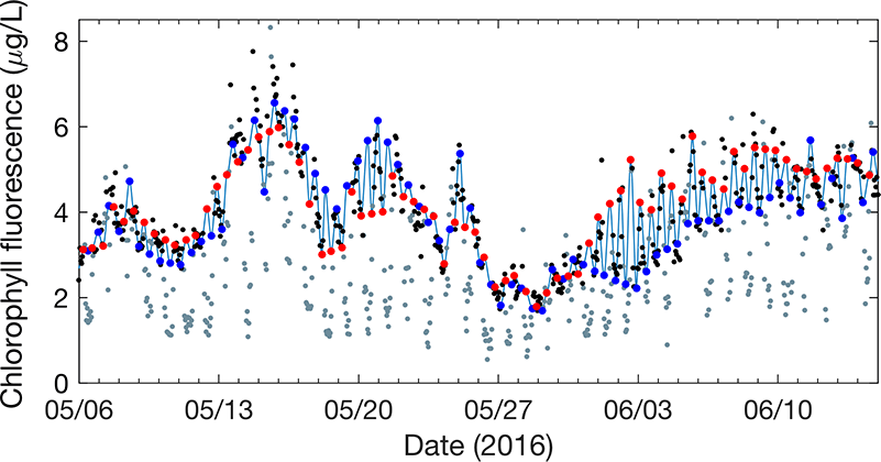
In a recent study in L&O Methods, authors developed a model that uses measurements of tidal velocity to correct daytime chlorophyll fluorescence for non-photochemical quenching and tidal advection. The model identifies high tide and low tide endmember populations of phytoplankton from tidal velocity, and estimates daytime chlorophyll fluorescence as a conservative interpolation between endmember fluorescence at those tidal maxima and minima (Figure 1). Rather than removing nearly 12 hours’ worth of hourly chlorophyll fluorescence observations (i.e., all of the daytime observations) as was previously necessary, this model recovers them. The model output performs more accurately as a proxy for chlorophyll concentration than raw daytime chlorophyll fluorescence measurements by a factor of two, and enables tracking of phytoplankton populations with chlorophyll fluorescence in a Lagrangian sense from Eulerian measurements. Finally, because the model assumes conservation, periods of non-conservative variability are revealed by comparison between model and measurements, helping to elucidate controls on variability in phytoplankton abundance in coastal waters.

Figure 1: Model (light blue line) is a tidal interpolation between high tide (blue points) and low tide (red points) phytoplankton endmembers. The model represents nighttime, unquenched chlorophyll fluorescence measurements well (black points), while daytime, quenched measurements are visibly reduced (gray points).

This result is a critical achievement, as it enables the use of daytime chlorophyll fluorescence, which increases the temporal resolution of coastal chlorophyll fluorescence measurements, and also provides a mechanism for satellite validation of the ocean color chlorophyll data product in coastal waters. The model’s capacity to accurately simulate the pervasive effect of non-photochemical quenching makes it a vital tool for any researcher or coastal water manager measuring chlorophyll fluorescence. This model will help to provide new insights on the movement of and controls on phytoplankton populations across the land-ocean continuum.

Authors:
Luke Carberry (University of California, Santa Barbara)
Collin Roesler (Bowdoin College)
Susan Drapeau (Bowdoin College)


Upwelled hydrothermal Fe stimulates massive phytoplankton blooms in the Southern Ocean

Posted by mmaheigan 
· Tuesday, July 9th, 2019 

Joint feature with GEOTRACES

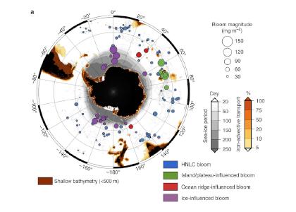
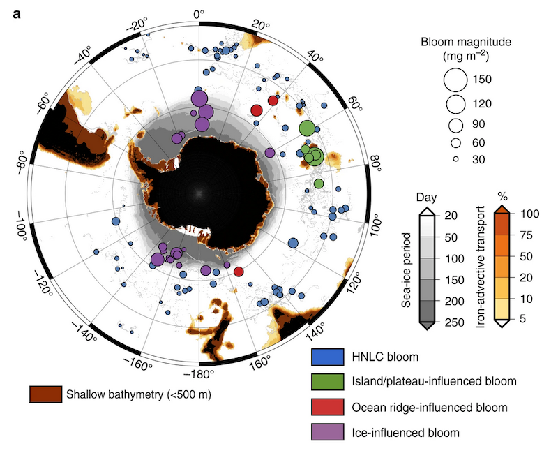
Figure 1a: Southern Ocean phytoplankton blooms showing distribution, biomass (circle size) and type (color key).

In a recent study, Ardyna et al combined observations of profiling floats with historical trace element data and satellite altimetry and ocean color data from the Southern Ocean to reveal that dissolved iron of hydrothermal origin can be upwelled to the surface. Furthermore, the activity of deep hydrothermal sources can influence upper ocean biogeochemical cycles of the Southern Ocean, and in particular stimulate the biological carbon pump.

Authors:
Mathieu Ardyna
Léo Lacour
Sara Sergi
Francesco d’Ovidio
Jean-Baptiste Sallée
Mathieu Rembauville
Stéphane Blain
Alessandro Tagliabue
Reiner Schlitzer
Catherine Jeandel
Kevin Robert Arrigo
Hervé Claustre

Ocean color offers early warning signal of climate change’s impact on marine phytoplankton

Posted by mmaheigan 
· Monday, April 15th, 2019 

Marine phytoplankton form the foundation of the marine food web and play a crucial role in the earth’s carbon cycle. Typically, satellite-derived Chlorophyll a (Chl a) is used to evaluate trends in phytoplankton. However, it may be many decades (or longer) before we see a statistically significant signature of climate change in Chl a due to its inherently large natural variability. In a recent study in Nature Communications, authors explored how other metrics, in particular the color of the ocean, may show earlier and stronger signals of climate change at the base of the marine food web.

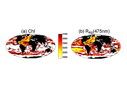
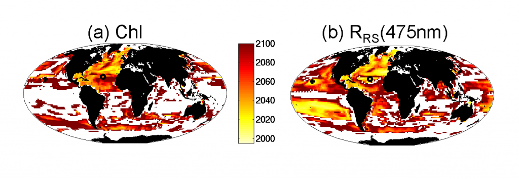
Figure 1. Computer model results indicating the year in which the signature of climate change impact is larger than the natural variability for (a) Chl a, and (b) remotely sensed reflectance in the blue-green waveband. White areas indicate where there is not a statistically significant change by 2100, or for regions that are currently ice-covered.


In this study, the authors use a unique marine physical-biogeochemical and ecosystem model that also captures how light penetrates the ocean and is reflected upward. The model shows that over the course of the 21st century, remote sensing reflectance (RRS, the ratio of upwelling radiance to the downwelling irradiance at the ocean’s surface) in the blue-green portions of the light spectrum is likely to have an earlier, more spatially extensive climate change-driven signal than Chl a (Figure 1). This is because RRS integrates not only changes to Chl a, but also alterations in other optically important water constituents. In particular, RRS also captures changes in phytoplankton community structure, which strongly affects ocean optics and is likely to be altered over the 21st century. Monitoring the response of marine phytoplankton to climate change is important for predicting changes at higher trophic levels, including commercial fisheries. Our study emphasizes the importance of 1) maintaining ocean color sensor compatibility and long-term stability, particularly in the blue-green wavebands; 2) maintaining long-term in situ time-series of plankton communities – e.g., the Continuous Plankton Recorder survey and repeat stations (e.g., HOT, BATS); and 3) reducing uncertainties in satellite-derived phytoplankton community structure estimates.


Authors:
Stephanie Dutkiewicz, Oliver Jahn (Massachusetts Institute of Technology)
Anna E. Hickman (University of Southampton)
Stephanie Henson (National Oceanography Centre Southampton)
Claudie Beaulieu (University of California, Santa Cruz)
Erwan Monier (University of California, Davis)

Dramatic Increase in Chlorophyll-a Concentrations in Response to Spring Asian Dust Events in the Western North Pacific

Posted by mmaheigan 
· Tuesday, October 23rd, 2018 

According to Martin’s iron hypothesis, input of aeolian dust into the ocean environment temporarily relieves iron limitation that suppresses primary productivity. Asian dust events that originate in the Taklimakan and Gobi Deserts occur primarily in the spring and represent the second largest global source of dust to the oceans. The western North Pacific, where productivity is co-limited by nitrogen and iron, is located directly downwind of these source regions and is therefore an ideal location for determining the response of open water primary productivity to these dust input events.

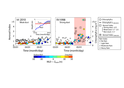
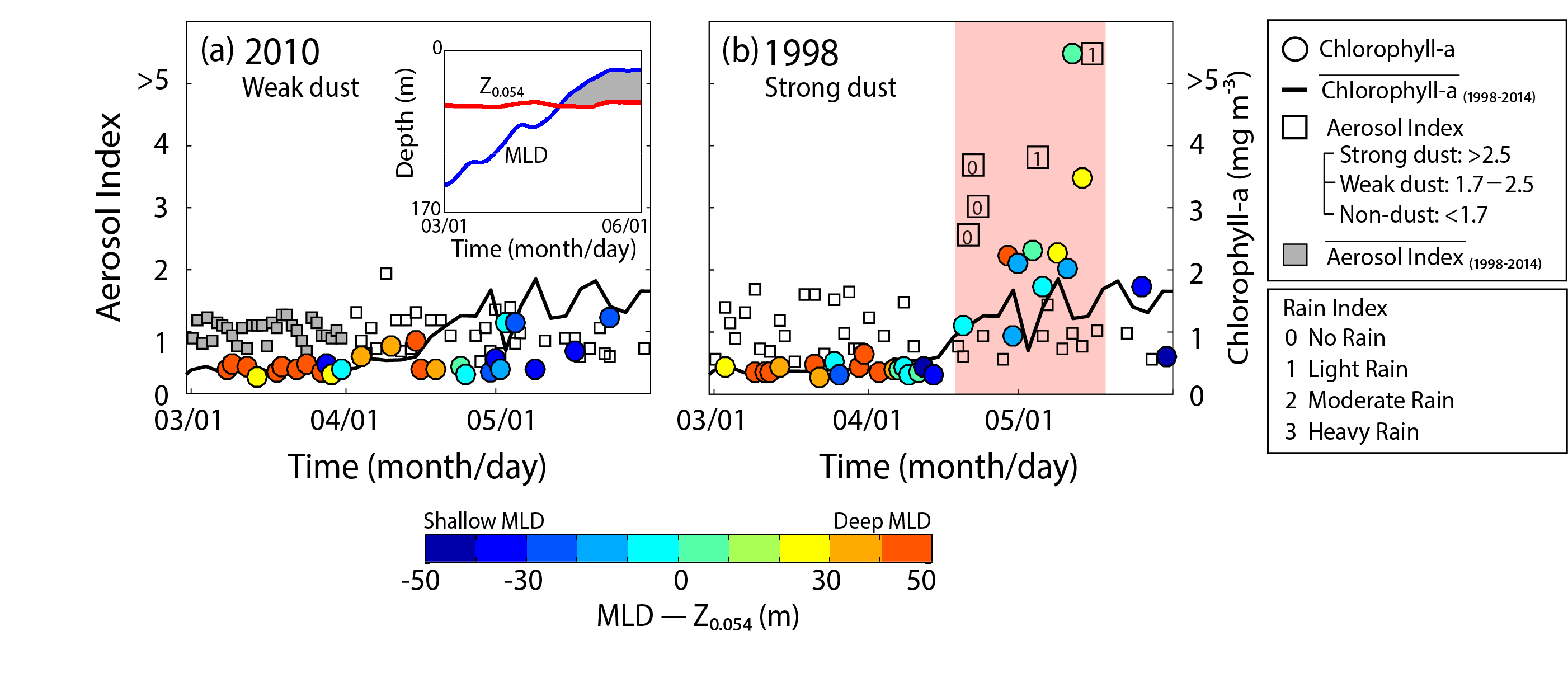
Figure 1. Daily aerosol index values (black squares) and chlorophyll-a concentrations (mg m-3, circles) during the spring (a) 2010 (weak dust event), (b) 1998 (strong dust event) in the western North Pacific. Color scale represents difference between mixed layer depth (MLD) and isolume depth (Z0.054) that indicates conditions for typical spring blooms; water column structures of MLD and isolume were identical in the spring of 1998 and 2010. Dramatic increases in chlorophyll-a (pink shading, maximum of 5.3 mg m-3) occurred in spring 1998 with a lag time of ~10 days after the strong dust event (aerosol index >2.5) on approximately April 20 compared to constant chlorophyll-a values (<2 mg m-3) in the spring of 2010.

A recent study in Geophysical Research Letters included an analysis of the spatial dynamics of spring Asian dust events, from the source regions to the western North Pacific, and their impacts on ocean primary productivity from 1998 to 2014 (except for 2002–2004) using long-term satellite observations (daily aerosol index data and chlorophyll-a). Geographical aerosol index distributions revealed three different transport pathways supported by the westerly wind system: 1) Dust moving predominantly over the Siberian continent (>50°N); 2) Dust passing across the northern East/Japan Sea (40°N‒50°N); and 3) Dust moving over the entire East/Japan Sea (35°N‒55°N). The authors observed that strong dust events could increase ocean primary productivity by more than 70% (>2-fold increase in chlorophyll-a concentrations, Figure 1) compared to weak/non-dust conditions. This result suggests that spring Asian dust events, though episodic, may play a significant role in driving the biological pump, thus sequestering atmospheric CO2 in the western North Pacific.

Another recent study reported that anthropogenic nitrogen deposition in the western North Pacific has significantly increased over the last three decades (i.e. relieving nitrogen limitation), whereas this study indicated a recent decreasing trend in the frequency of spring Asian dust events (i.e. enhancing iron limitation). Further investigation is required to fully understand the effects of contrasting behavior of iron (i.e., decreasing trend) and nitrogen (i.e., increasing trend) inputs on the ocean primary productivity in the western North Pacific, paying attention on how the marine ecosystem and biogeochemistry will respond to the changes.


Authors:
Joo-Eun Yoon (Incheon National University)
Il-Nam Kim (Incheon National University)
Alison M. Macdonald (Woods Hole Oceanographic Institution)

Satellite Laser Lights Up Polar Research

Posted by mmaheigan 
· Thursday, April 13th, 2017 

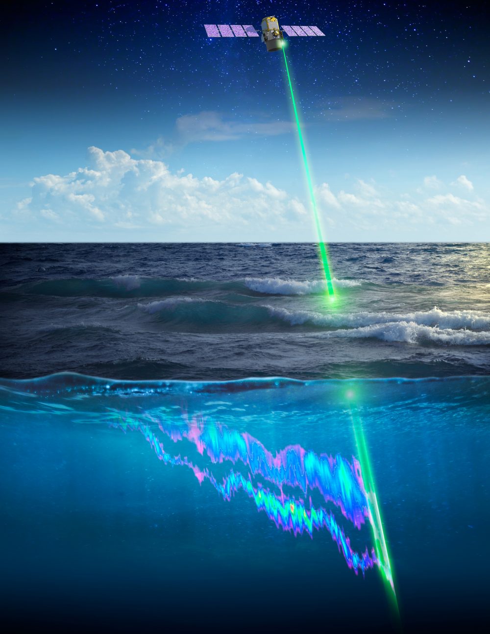
What controls annual cycles and interannual changes in polar phytoplankton biomass? Answers to this question are now emerging from a satellite light detection and ranging (lidar) sensor, which can observe the polar oceans throughout the extensive periods when measurements from traditional passive ocean color sensors are impossible. The new study uses active lidar measurements from the CALIOP satellite sensor to construct complete decade-long record of phytoplankton biomass in the northern and southern polar regions. Results of the study show that annual cycles in biomass are driven by rates of acceleration and deceleration in phytoplankton division, with bloom termination coinciding with maximum division rates irrespective of whether nutrients are exhausted. The study further shows that interannual differences in bloom strength can be quantitatively related to the difference between the winter minimum to summer maximum in division rates. Finally, the analysis indicated that ecological processes had a greater impact than ice cover changes on integrated polar zone phytoplankton biomass in the north, whereas ice cover changes were the dominant driver in the south polar zone. Despite being designed for atmospheric research, CALIOP has provided the first demonstration that active satellite lidar measurements can yield important new insights on plankton ecology in the climate sensitive polar regions. This proof-of-concept creates a foundation for a future ocean-optimized sensor with water-column profiling capabilities that would launch a new lidar era in satellite oceanography.


Authors:

Michael J. Behrenfeld (Oregon State Univ.)
Yongxiang Hu (NASA Langley Research Center)
Robert T. O’Malley (Oregon State Univ.)
Emmanuel S. Boss (Univ. Maine)
Chris A. Hostetler (NASA Langley Research Center)
David A. Siegel (Univ. California Santa Barbara)
Jorge Sarmiento (Princeton Univ.)
Jennifer Schulien (Oregon State Univ.)
Johnathan W. Hair (NASA Langley Research Center)
Xiaomei Lu (NASA Langley Research Center)
Sharon Rodier (NASA Langley Research Center)
Amy Jo Scarino (NASA Langley Research Center)

Mesodinium rubrum: An Old Bug Meets New Technology

Posted by mmaheigan 
· Tuesday, April 12th, 2016 

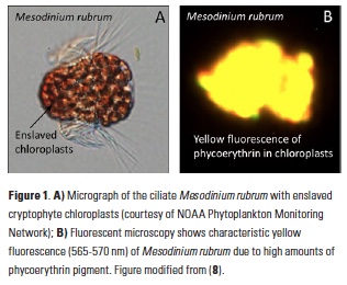
Blooms of red water associated with the remarkable ciliate Mesodinium rubrum have been observed at least since Darwin’s time (1). This ciliate retains the chloroplasts from ingested prey and is able to use them for photosynthesis (reviewed in 2). Recent studies have shown that the plastids can reproduce within the ciliate and that nuclei from the original algal prey remain
transcriptionally active (3). It is very likely that there are at least two different species of Mesodinium that perform this feat, the original M. rubrum and a recently described larger species, M. major (4). Both species have in common certain species of cryptophyte
algae as their preferred food, and hence are colored deep red by their prey’s phycoerythrin pigment and characteristic yellow fluorescence (Fig. 1). Mesodinium is believed to hold the ciliate swimming speed record, with short jumps of up to 1.2 cm s-1, and can change its position vertically in the water column to access nutrients (5). Along with rapid growth, its impressive motility probably contributes to the large aggregations obvious to the naked eye, in which concentrations of >106 cells l-1 have been observed (6 ) (Fig. 1). Even outside of bloom conditions, they are a regular component of estuarine and coastal plankton assemblages and can contribute significantly to primary productivity (7). However, as mixotrophs (organisms capable
of both photosynthesis and ingestion), they are undersampled and underappreciated by phytoplankton and zooplankton ecologists alike.

Red water has been reported in Long Island Sound on occasion by other observers. While Mesodinium was present in >80% of all samples examined in >10 years of monthly plankton monitoring data, no sample ever exceeded 2.6 x 10⁴ cells l-1. In Fall 2012, Univ. Connecticut personnel servicing a moored array observed and sampled red water in western Long Island Sound (40.9°N 73.6°W). Microscopy and DNA sequencing confirmed that the bloom was due to Mesodinium (100% identical by small subunit rDNA to the larger M. major), and we subsequently reported on our efforts to document the bloom using satellite imagery (8). Here, we summarize those results and discuss the promise of new sensors for quantifying blooms of specific plankton groups by their pigment signatures, especially when coarsely resolved monitoring samples are inadequate.

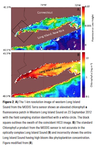
Ocean color satellites provide a means to assess such red tides, but the standard chlorophyll products are inaccurate in the optically complex waters of Long Island Sound, which contain river runoff with colored dissolved organic matter (cDOM) and suspended sediments (9, 10) (Fig 2). Imagery from the MODIS sensor of fluorescence line height (Fig. 2A) indicated the presence of an unspecified bloom in Western Long Island Sound coincident with the bloom, but the spatial resolution (1-km pixels) did not allow us to gauge the bloom extent adequately, and the spectral bands of that sensor are not sufficient to discriminate the type of bloom.

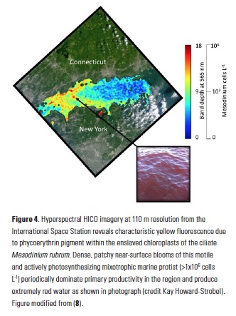
Serendipitously, an image was available for the western Sound from the novel Hyperspectral Imager for the Coastal Ocean (HICO) instrument aboard the International Space Station. This sensor contains >100 channels in the visible and near infrared regions of the spectrum and hence has the capability to resolve multiple peaks and valleys due to fluorescence and absorbance of the chlorophylls and accessory pigments found in various phytoplankton groups. It also has the higher spatial resolution (110-m pixels) needed to quantify the extent of the bloom and variation in ciliate abundance within it. Because the red water we observed appeared (microscopically) to be almost exclusively due to Mesodinium, the HICO reflectance spectrum was an almost pure example of the in situ optical signature of this unique organism (i.e. an “endmember” in remote sensing terminology).

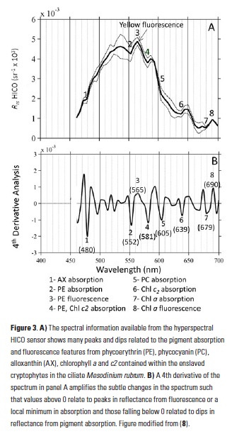
In addition to phycoerythrin, the cryptophyte chloroplasts that the ciliate retains contain chlorophyll-a, chlorophyll-c2, phycocyanin, and the carotenoid alloxanthin. The reflectance spectrum measured with the HICO sensor revealed features related to the fluorescence and absorption associated with these pigments that can be used as a spectral “fingerprint” of this specific organism (Fig. 3A). With reflectance measured across the full visible spectrum, small dips in the spectrum can be revealed with a 4th derivative analysis and related to the associated pigments (11) (Fig. 3B). In addition to absorbing green light, phycoerythrin also fluoresces yellow light (12) (Fig. 1B) and a peak in reflectance was observed at ~565 nm associated with this feature. This unique fluorescence feature allowed us to map the surface distribution of Mesodinium in Long Island Sound. Traditional ocean color satellites do not measure reflectance of light at this waveband, but yellow fluorescence (band depth at 565 nm) could be detected from the hyperspectral measurements of HICO and related to the relative amount of Mesodinium up to the measured 106 cells L-1 with distinctly red colored water (Fig. 4).

The fine-scale distribution of the HICO imagery reveals that Mesodinium was found in small 100-m patches along the sea surface rather than distributed throughout a single multi-kilometer patch as suggested by the 1-km MODIS imagery (Fig 2A). Such high spatial resolution from aircraft has been used to assess concentration mechanisms of blooms, including internal waves (13) and Langmuir circulation (14). Further research is underway to assess the observed patterns with hydrographic and air-sea processes local to this region. Understanding the spatial distribution may also lead to a better understanding of the environmental factors that lead to these episodic blooms of Mesodinium. Generally, Mesodinium is more abundant in lower salinity estuarine water, but the causes of bloom initiation and demise are not well known (15).

Though now defunct, the HICO sensor should serve as a model for remote sensing in the coastal zone. With its high spectral and spatial resolution, images from HICO could be used to assess coastal processes, as highlighted here, but only at infrequent intervals. While possible with airborne technology, no existing or planned satellite sensor can sample at high spectral, spatial, and temporal resolution for adequate monitoring of the coastal zone. Providing near-daily coverage for much of the globe, the next generation NASA ocean color sensor, Pre-Aerosol, Cloud and ocean Ecosystems (PACE), is slated to have the unique hyperspectral capabilities to allow for better discrimination of marine blooms and habitats, but with a larger km-scale resolution. International sensors with new capabilities will also help to fill this gap (16). With new hyperspectral technology in space, autonomous and routine differentiation of phyto- and mixotrophic plankton blooms in surface waters may be possible and could provide an important tool for resource managers. Improved monitoring of bloom-forming plankton will also lead to more refined estimates of coastal primary productivity and mechanisms for their episodic growth and decline. If future sensors or sensor constellations combine high repeat sampling with the hyperspectral capabilities and high spatial resolution of HICO, we will be able to understand not only the composition and extent of blooms, but also the sub-mesoscale processes that drive their persistence and spatial structure.

Authors

Heidi Dierssen and George McManus (University of Connecticut)

Acknowledgments

We thank Kay Howard-Strobel, Senjie Lin, and the NOAA Phytoplankton Monitoring Network for images of the bloom and of Mesodinium. Dajun Qiu verified the genetic identity of the ciliate. Adam Chlus and Bo-Cai Gao contributed to the image processing. We also thank the HICO Science Team and NASA Ocean Biology Distributed Active Archive Center for providing satellite imagery.

References

  1. Darwin, C., 1909. The Voyage of the Beagle, P.F. Collier.
  2. Crawford, D. W., 1989. Mar. Ecol. Prog. Ser. Oldendorf 58, 161–174.
  3. Johnson, M. D. et al., 2007. Nature 445, 426–428.
  4. Garcia-Cuetos, L. et al., 2012. J. Eukaryot. Microbiol. 59, 374–400.
  5. Crawford, D. W., T. Lindholm, 1997. Aquat. Microb. Ecol. 13, 267–274.
  6. Taylor, F. J. R. et al., 1971. J. Fish. Board Can. 28, 391–407.
  7. Smith, W. O., R. T. Barber, 1979. J. Phycol. 15, 27–33.
  8. Dierssen, H. et al., 2015. Proc. Natl. Acad. Sci., doi:10.1073/pnas.1512538112.
  9. Aurin, D. A., H. M. Dierssen, 2012. Remote Sens. Environ. 125, 181–197.
  10. Aurin, D. A. et al., 2010. J. Geophys. Res. 115, 1–11.
  11. Bidigare, R. R. et al., 1989. J. Mar. Res. 47, 323–341.
  12. McManus, G. B., J. A. Fuhrman, 1986. J. Plankton Res. 8, 317–327.
  13. Ryan, J. P. et al., 2005. Oceanography 18, 246–255.
  14. Dierssen, H. M. et al., 2015. Remote Sens. Environ. 167, 247–258.
  15. Herfort, L. et al., 2011. Estuar. Coast. Shelf Sci. 95, 440–446.
  16. International Ocean Colour Coordinating Group (IOCCG). www.ioccg.org

Filter by Keyword

234Th disequilibrium abundance acidification africa air-sea flux air-sea interactions air-sea interface algae alkalinity allometry ammonium AMOC anoxia anoxic Antarctic anthro impacts anthropogenic carbon aquaculture aragonite saturation arctic Argo argon arsenic artificial seawater Atlantic Atlantic modeling atmospheric carbon atmospheric CO2 atmospheric nitrogen deposition authigenic carbonates autonomous platforms bacteria BATS BCG Argo benthic bgc argo bio-go-ship bio-optical bioavailability biogeochemical cycles biogeochemical cycling biogeochemical models biogeochemistry Biological Essential Ocean Variables biological pump biological uptake biophysics bloom blooms blue carbon bottom water boundary layer buffer capacity C14 CaCO3 calcification calcite calcium carbonate carbon carbon-climate feedback carbon-sulfur coupling carbon budget carbon cycle carbon dioxide carbon export carbon sequestration carbon storage Caribbean CCA CCS changi changing marine ecosystems changing marine environments changing ocean chemistry chemical oceanographic data chemical speciation chemoautotroph chesapeake bay chl a chlorophyll circulation climate change climate variability CO2 CO2YS coastal darkening coastal ocean cobalt Coccolithophores community composition conservation cooling effect copepod coral reefs CTD currents cyclone data data access data management data product Data standards DCM dead zone decadal trends decomposers decomposition deep convection deep ocean deep sea coral deoxygenation depth diagenesis diatoms DIC diel migration diffusion dimethylsulfide dinoflagellate discrete measurements dissolved inorganic carbon dissolved organic carbon DOC DOM domoic acid dust DVM earth system models ecology ecosystems ecosystem state eddy Education Ekman transport emissions ENSO enzyme equatorial regions error ESM estuarine and coastal carbon estuarine and coastal carbon fluxes estuary euphotic zone eutrophication evolution export export fluxes export production EXPORTS extreme events extreme weather events faecal pellets filter feeders filtration rates fire fish Fish carbon fisheries floats fluid dynamics fluorescence food webs forage fish forams freshening freshwater frontal zone fronts functional role future oceans geochemistry geoengineering geologic time GEOTRACES glaciers gliders global carbon budget global ocean global warming go-ship grazing greenhouse gas Greenland groundwater Gulf of Maine Gulf of Mexico Gulf Stream gyre harmful algal bloom high latitude human food human impact hurricane hydrogen hydrothermal hypoxia ice age ice cores ice cover industrial onset inverse circulation ions iron iron fertilization isotopes jellies katabatic winds kelvin waves krill kuroshio laboratory vs field land-ocean continuum larvaceans lateral transport LGM lidar ligands light light attenuation lipids mangroves marine carbon cycle marine heatwave marine particles marine snowfall marshes Mediterranean meltwater mesopelagic mesoscale metagenome metals methane methods microbes microlayer microorganisms microscale microzooplankton midwater mixed layer mixed layers mixing mixotrophy modeling models mode water molecular diffusion MPT multi-decade n2o NAAMES NASA NCP net community production net primary productivity new ocean state new technology Niskin bottle nitrate nitrogen nitrogen cycle nitrogen fixation nitrous oxide north atlantic north pacific nuclear war nutricline nutrient budget nutrient cycling nutrient limitation nutrients OA ocean-atmosphere ocean acidification ocean acidification data ocean carbon uptake and storage ocean color ocean observatories ocean warming ODZ oligotrophic omics OMZ open ocean optics organic particles oscillation overturning circulation oxygen pacific paleoceanography particle flux particles pCO2 PDO peat pelagic PETM pH phenology phosphorus photosynthesis physical processes physiology phytoplankton PIC plankton POC polar regions pollutants precipitation predation prediction primary production primary productivity Prochlorococcus proteins pteropods pycnocline radioisotopes remineralization remote sensing repeat hydrography residence time resource management respiration resuspension rivers rocky shore Rossby waves Ross Sea ROV salinity salt marsh satell satellite scale seafloor seagrass sea ice sea level rise seasonal patterns seasonal trends sea spray seaweed sediments sensors shelf system shells ship-based observations shorelines silicate silicon cycle sinking particles size SOCCOM soil carbon southern ocean south pacific spatial covariations speciation SST stoichiometry subduction submesoscale subpolar subtropical sulfate surf surface surface ocean Synechococcus teleconnections temperate temperature temporal covariations thermocline thermodynamics thermohaline thorium tidal time-series time of emergence top predators total alkalinity trace elements trace metals trait-based transfer efficiency transient features Tris trophic transfer tropical turbulence twilight zone upper ocean upper water column upwelling US CLIVAR validation velocity gradient ventilation vertical flux vertical migration vertical transport volcano warming water clarity water quality waves western boundary currents wetlands winter mixing world ocean compilation zooplankton

Copyright © 2023 - OCB Project Office, Woods Hole Oceanographic Institution, 266 Woods Hole Rd, MS #25, Woods Hole, MA 02543 USA Phone: 508-289-2838  •  Fax: 508-457-2193  •  Email: ocb_news@us-ocb.org

link to nsflink to noaalink to WHOI

Funding for the Ocean Carbon & Biogeochemistry Project Office is provided by the National Science Foundation (NSF) and the National Aeronautics and Space Administration (NASA). The OCB Project Office is housed at the Woods Hole Oceanographic Institution.