Ocean Carbon & Biogeochemistry
Studying marine ecosystems and biogeochemical cycles in the face of environmental change
  • Home
  • About OCB
    • About Us
    • Scientific Breadth
      • Biological Pump
      • Changing Marine Ecosystems
      • Changing Ocean Chemistry
      • Estuarine and Coastal Carbon Fluxes
      • Ocean Carbon Uptake and Storage
      • Ocean Observatories
    • Code of Conduct
    • Get Involved
    • Project Office
    • Scientific Steering Committee
    • OCB committees
      • Ocean Time-series
      • US Biogeochemical-Argo
      • Ocean-Atmosphere Interaction
  • Activities
    • Summer Workshop
    • OCB Webinars
    • Guidelines for OCB Workshops & Activities
    • Topical Workshops
      • CMIP6 Models Workshop
      • Coastal BGS Obs with Fisheries
      • C-saw extreme events workshop
      • Expansion of BGC-Argo and Profiling Floats
      • Fish, fisheries and carbon
      • Future BioGeoSCAPES program
      • GO-BCG Scoping Workshop
      • Lateral Carbon Flux in Tidal Wetlands
      • Leaky Deltas Workshop – Spring 2025
      • Marine CDR Workshop
      • Ocean Nucleic Acids ‘Omics
      • Pathways Connecting Climate Changes to the Deep Ocean
    • Small Group Activities
      • Aquatic Continuum OCB-NACP Focus Group
      • Arctic-COLORS Data Synthesis
      • BECS Benthic Ecosystem and Carbon Synthesis WG
      • Carbon Isotopes in the Ocean Workshop
      • CMIP6 WG
      • Filling the gaps air–sea carbon fluxes WG
      • Fish Carbon WG
      • Meta-eukomics WG
      • mCDR
      • Metaproteomic Intercomparison
      • Mixotrophs & Mixotrophy WG
      • N-Fixation WG
      • Ocean Carbonate System Intercomparison Forum
      • Ocean Carbon Uptake WG
      • OOI BGC sensor WG
      • Operational Phytoplankton Observations WG
      • Phytoplankton Taxonomy WG
    • Other Workshops
    • Science Planning
      • Coastal CARbon Synthesis (CCARS)
      • North Atlantic-Arctic
    • Ocean Acidification PI Meetings
    • Training Activities
      • PACE Hackweek 2025
      • PACE Hackweek 2024
      • PACE Training Activity 2022
  • Science Support
    • Data management and archival
    • Early Career
    • Funding Sources
    • Jobs & Postdocs
    • Meeting List
    • OCB Topical Websites
      • Ocean Fertilization
      • Trace gases
      • US IIOE-2
    • Outreach & Education
    • Promoting your science
    • Student Opportunities
    • OCB Activity Proposal Solicitations
      • Guidelines for OCB Workshops & Activities
    • Travel Support
  • Publications
    • OCB Workshop Reports
    • Science Planning and Policy
    • Newsletter Archive
  • Science Highlights
  • News

Archive for land-ocean continuum

What drives decadal changes in the Chesapeake Bay carbonate system?

Posted by mmaheigan 
· Tuesday, May 3rd, 2022 

Understanding decadal changes in the coastal carbonate system (CO2-system) is essential for predicting how the health of these waters is affected by anthropogenic drivers, such as changing atmospheric conditions and terrestrial inputs. However, studies that quantify the relative impacts of these drivers are lacking.

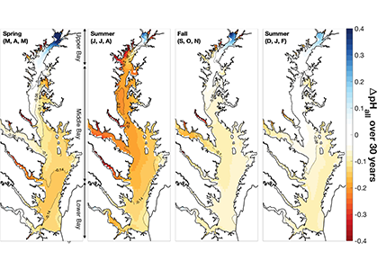
A recent study in Journal of Geophysical Research: Oceans identified the primary drivers of acidification in the Chesapeake Bay over the past three decades. The authors used a three-dimensional hydrodynamic-biogeochemistry model to quantify the relative impacts on the Bay CO2-system from increases in atmospheric CO2, temperature, oceanic dissolved inorganic carbon (DIC) concentrations, terrestrial loadings of total alkalinity (TA) and DIC, as well as decreases in terrestrial nutrient inputs. Decadal changes in the surface CO2-system in the Chesapeake Bay exhibit large spatial and seasonal variability due to the combination of influences from the land, ocean and atmosphere. In the upper Bay, increased riverine TA and DIC from the Susquehanna River have increased surface pH, with other drivers only contributing to decadal changes that are one to two orders of magnitude smaller. In the mid- and lower Bay, higher atmospheric CO2 concentrations and reduced nutrient loading are the two most critical drivers and have nearly equally reduced surface pH in the summer. These decadal changes in surface pH show significant seasonal variability with the greatest magnitude generally aligning with the spring and summer shellfish production season (Figure 1).

Figure 1: Overall changes in modeled surface pH (ΔpHall) due to all global and terrestrial drivers combined over the past 30 years (i.e., 2015–2019 relative to 1985–1989). ΔpHall includes changes in surface pH due to increased atmospheric CO2, increased atmospheric thermal forcing, increased oceanic dissolved inorganic carbon concentrations, decreased riverine nitrate concentrations, decreased riverine organic nitrogen concentrations, and increased riverine total alkalinity and dissolved inorganic carbon concentrations.


These results indicate that a number of global and terrestrial drivers play crucial roles in coastal acidification. The combined effects of the examined drivers suggest that calcifying organisms in coastal surface waters are likely facing faster decreasing rates of pH than those in open ocean ecosystems. Decreases in surface pH associated with nutrient reductions highlight that the Chesapeake Bay ecosystem is returning to a more natural condition, e.g., a condition when anthropogenic nutrient input from the watershed was lower. However, increased atmospheric CO2 is simultaneously accelerating the rate of change in pH, exerting increased stress on estuarine calcifying organisms. For ecosystems such as the Chesapeake Bay where nutrient loading is already being managed, controlling the emissions of anthropogenic CO2 globally becomes increasingly important to decelerate the rate of acidification and to relieve the stress on estuarine calcifying organisms. Future observational and modeling studies are needed to further investigate how the decadal trends in the Chesapeake Bay CO2-system may vary with depth. These efforts will improve our current understanding of long-term change in coastal carbonate systems and their impacts on the shellfish industry.


Authors:
Fei Da (Virginia Institute of Marine Science, William & Mary, USA)
Marjorie A. M. Friedrichs (Virginia Institute of Marine Science, William & Mary, USA)
Pierre St-Laurent (Virginia Institute of Marine Science, William & Mary, USA)
Elizabeth H. Shadwick (CSIRO Oceans and Atmosphere, Australia)
Raymond G. Najjar (The Pennsylvania State University, USA)
Kyle E. Hinson (Virginia Institute of Marine Science, William & Mary, USA)

Extreme events are accelerating coastal carbon cycling

Posted by mmaheigan 
· Monday, March 1st, 2021 

The world is getting stormier, and recent evidence shows significant impacts on coastal carbon cycling. The upticks in extreme weather events such as tropical cyclones have resulted in enhanced delivery of nutrients and organic matter across the land-ocean continuum. Lagoonal estuaries such as the Albemarle-Pamlico Sound (APS) in North Carolina and Galveston Bay in Texas are key coastal environments in which we can observe the long-term carbon cycling consequences of these events. Residence times of these coastal environments are on the order of months to over a year, providing ample opportunity for biogeochemical processing. Emerging from studies of Atlantic and Gulf of Mexico hurricanes in 2016 and 2017 is a clear example of the role of terrestrial dissolved organic carbon (DOC) as a key reactant driving the observed carbon cycling and ecosystem effects ( Figure 1).

Figure. 1. The impact of hurricanes on CO2 fluxes (top) and terrestrial DOC decay constants (bottom) demonstrate the sustained effect on the coastal carbon cycle caused by extreme weather events. Top panel shows results from Hurricane Matthew in 2016, where date is month and day and Km downstream represents observations taken along the main axis of the Neuse River Estuary and lower Pamlico Sound, eastern North Carolina. FCO2 is the daily sea-to-air flux of CO2 estimated from measurements of temperature, salinity, dissolved inorganic carbon, and wind speed. The results indicate the Sound existed as a weak yet sustained CO2 source to the atmosphere well after the storm. Outgassing of CO2 is driven by the rapid mineralization of terrestrial DOC. Bottom panel shows the high bioreactivity of flood-derived terrestrial DOC indicated by elevated microbial decay constants for Galveston Bay and the coastal Gulf of Mexico in 2017 as compared to high and low latitude coastal environments.

In coastal North Carolina, 36 tropical cyclones (TCs), including three floods of historical significance in the past two decades, have occurred in the past 20 years. The lingering effects of these storms include extensive periods of carbon dioxide (CO2) supersaturation. For example, Hurricane Matthew in 2016 caused the lower Pamlico Sound to emit CO2 for months after the passage of the storm. With similar results documented for the Pamlico Sound for storms in 2011 and 2012, there is solid evidence that shifts in the ecosystem state of this mesotrophic estuary from net autotrophic to net heterotrophic are a major effect of this process.

Reactive DOC from the landscape appears to be driving the shift in ecosystem state.  Large plumes of brown-colored DOC are observable from space in numerous satellite images of the Atlantic and Gulf coasts following these storms. The color is part of a phenomenon known as “coastal darkening"—spectroscopic, stable isotopic, and biomarker evidence show this darkening is related to the flushing of wetlands in the flood-plain adjacent to the rivers draining into these estuaries.

Along the Texas coast, Hurricane Harvey produced the largest rainfall event recorded in US history and caused extensive flooding in 2017. Similar to results from coastal North Carolina, flood-derived terrestrial DOC in Galveston Bay exhibited high bioreactivity, with decay constants exceeding those observed for terrestrial DOC across coastal environments from high and low latitudes by almost three-fold. The rapid processing of terrestrial DOC was linked to an active microbial community capable of decomposing aromatic compounds that are abundant in colored DOC as indicated by genomic analyses. These recent studies clearly demonstrate the impacts of large storm events on coastal carbon cycling via the transport of reactive terrestrial DOC into coastal waters. Climate-driven increases in the frequency and intensity of such storm events warrant more sustained capacity to monitor episodic deliveries of carbon and nutrients and their impacts on coastal marine ecosystems.


Authors:
Chris Osburn (North Carolina State University) @closburn
Hans Paerl (University of North Carolina, Institute of Marine Sciences)
Ge Yan (Institute of Deep-Sea Science and Engineering, Chinese Academy of Sciences)
Karl Kaiser (Texas A&M University, Galveston Campus)


Citations:

Yan, G., Labonté, J. M., Quigg, A., & Kaiser, K. (2020). Hurricanes accelerate dissolved organic carbon cycling in coastal ecosystems. Frontiers in Marine Science, 7, 248.

Osburn, C. L., Rudolph, J. C., Paerl, H. W., Hounshell, A. G., & Van Dam, B. R. (2019). Lingering carbon cycle effects of Hurricane Matthew in North Carolina's coastal waters. Geophysical Research Letters, 46(5), 2654-2661.

Wildfire impacts on coastal ocean phytoplankton

Posted by mmaheigan 
· Wednesday, February 24th, 2021 

Wildfire frequency, size, and destructiveness has increased over the last two decades, particularly in coastal regions such as Australia, Brazil, and the western United States. While the impact of fire on land, plants, and people is well documented, very few studies have been able to evaluate the impact of fires on ocean ecosystems. A serendipitously planned research cruise one week after the Thomas Fire broke out in California in December 2017 allowed the authors of this study and their colleagues to sample the adjacent Santa Barbara Channel during this devastating extreme fire event.

In a recent paper published in Journal of Geophysical Research: Oceans, the authors describe the phytoplankton community in the Santa Barbara Channel during the Thomas Fire. Phytoplankton community composition was described using a combination of images of phytoplankton from the Imaging FlowCytobot (McLane Labs) and phytoplankton pigments. Dinoflagellates were the dominant phytoplankton group in the surface ocean during the Thomas Fire, according to both methods (Figure 1).

Figure 1. (A) The fraction of total particle volume imaged by the Imaging FlowCytobot (IFCB) comprised of phytoplankton (green) and detritus (brown). Example IFCB images of ash (counted as part of detritus) particles are outlined in brown. (B) The phytoplankton fraction is then further divided by taxonomy, showing the abundance of nano-sized phytoplankton and especially dinoflagellates during the week of sampling. Example IFCB images of Gonyaulax (outlined in dark green), Prorocentrum (outlined in light green), and Umbilicosphaera (outlined in purple) cells are also shown.


While this study was not able to demonstrate a causal relationship between the Thomas Fire and the presence of dinoflagellates, this result is quite different from previous winters in the Santa Barbara Channel, when picophytoplankton and diatoms typically dominate the winter community. The incidence of dinoflagellates in the Santa Barbara Channel in December 2017 was correlated with the warmer-than-average water temperature during this study, which matched observations from other areas along the Central California coast that winter.

At the time this study was conducted, the Thomas Fire was the largest wildfire in California history. Since then, California fires have increased in danger, destruction, and human mortality; the Mendocino Fire complex (summer 2018) and five separate wildfires in summer 2020 exceeded the impacts of the Thomas Fire. With wildfire severity and frequency increasing not only in California but in coastal regions worldwide, this study gives an important first look at the impact of wildfire smoke and ash on oceanic primary productivity and community composition.


Authors:
Sasha Kramer (University of California Santa Barbara)
Kelsey Bisson (Oregon State University)
Alexis Fischer (University of California Santa Cruz)

A new Regional Earth System Model of the Mediterranean Sea biogeochemical dynamics

Posted by mmaheigan 
· Thursday, November 19th, 2020 

The Mediterranean Sea is a semi-enclosed mid-latitude oligotrophic basin with a lower net primary production than the global ocean. A west-east productivity trophic gradient results from the superposition of biogeochemical and physical processes, including the biological pump and associated carbon and nutrient (nitrogen, phosphorus) fluxes, the spatial asymmetric distribution of nutrient sources (rivers, atmospheric deposition, coastal upwelling, etc.), the estuarine inverse circulation associated with the inflow of Atlantic water through the Gibraltar Strait. The complex and highly variable interface between land and sea throughout this basin add a further layer of complexity in the Mediterranean oceanic and atmospheric circulation and on the associated biogeochemistry dynamics, emphasizing the need for high-resolution truly integrated Regional Earth System Models to track and understand fine-scale processes and ecosystem dynamics.

In a recent paper published in the Journal of Advances in Modeling Earth System, the authors introduced a new version of the Regional Earth System model RegCM-ES and evaluated its performance in the Mediterranean region. RegCM-ES fully integrates the regional climate model RegCM4, the land surface scheme CLM4.5 (Community Land Model), the river routing model HD (Hydrological Discharge Model), the ocean model MITgcm (MIT General Circulation model) and the Biogeochemical Flux Model BFM.

A comparison with available observations has shown that RegCM-ES was able to capture the mean climate of the region and to reproduce horizontal and vertical patterns of chlorophyll-a and PO4 (the limiting nutrient in the basin) (Figure 1). The same comparison revealed a systematic underestimation of simulated dissolved oxygen (which will be fixed by the use of a new parametrization of oxygen solubility), and an overestimation of NO3, possibly due to uncertainties in initial and boundary conditions (mostly traced to river and Dardanelles nutrient discharges) and an overly vigorous vertical mixing simulated by the ocean model in some parts of the Basin.

Figure.1 Distributions of chlorophyll-a mg/m3 (top) and PO4 mmol/m3 (bottom) in the Mediterranean Sea as simulated by RegCM-ES.

Overall, this analysis has demonstrated that RegCM-ES has the capabilities required to become a powerful tool for studying regional dynamics and impacts of climate change on the Mediterranean Sea and other ocean basins around the world.


Authors:
Marco Reale (Abdus Salam International Centre for theoretical physics-ICTP, National Institute of Oceanography and Experimental Geophysics-OGS)
Filippo Giorgi (Abdus Salam International Centre for theoretical physics-ICTP)
Cosimo Solidoro (National Institute of Oceanography and Experimental Geophysics-OGS)
Valeria Di Biagio (National Institute of Oceanography and Experimental Geophysics-OGS)
Fabio Di Sante (Abdus Salam International Centre for theoretical physics-ICTP)
Laura Mariotti (National Institute of Oceanography and Experimental Geophysics-OGS)
Riccardo Farneti (Abdus Salam International Centre for theoretical physics-ICTP)
Gianmaria Sannino (Italian National Agency for New Technologies, Energy and Sustainable Economic Development-ENEA)

Arctic rivers as carbon highways

Posted by mmaheigan 
· Tuesday, June 16th, 2020 

Rapid environmental changes in the Arctic will potentially alter the atmospheric emissions of heat-trapping greenhouse gases such as methane (CH4) and carbon dioxide (CO2). A recent study on the Canadian Arctic published in Geophysical Research Letters reveals that spring meltwater delivery drives episodic outgassing events along the lake-river-bay continuum. This spring runoff period is not well-represented in prior studies, which, due to ease of sampling access, have focused more on summertime low-ice conditions. Study authors established a community-based monitoring program in Cambridge Bay and an adjacent inflowing river system in Nunavut, Canada from 2017-2018. These time-series data revealed that at the onset of the melt season river water contains methane concentrations up to 2000 times higher than observed in the bay from late summer through early spring (Figure 1 panel a). In addition, the authors deployed a novel robotic chemical sensing kayak (the ChemYak) in the Bay for five days in 2018 to densely sample water CH4 and CO2 levels in space and time during the spring thaw (Figure 1 panel b). The ChemYak observations revealed that river water containing elevated levels of both of these greenhouse gases flowed into the bay and outgassed to the atmosphere over a period of 5 days! The authors estimate that river inflow during the short melt season drives >95% of all annual methane emissions from the bay. These results demonstrate the need for seasonally-resolved sampling to accurately quantify greenhouse gas emissions from polar systems.

Figure 1: Panel a) Measurements of methane concentration in Cambridge Bay and an adjacent river showed strong seasonality; elevated concentrations were associated with river inflow at the start of the freshet. Panel b) Observations with the ChemYak robotic surface vehicle in Cambridge Bay revealed that excess methane was rapidly ventilated to the atmosphere following ice melt in the bay.


Authors
Cara Manning (University of British Columbia)
Victoria Preston (Woods Hole Oceanographic Institution and Massachusetts Institute of Technology)
Samantha Jones (University of Calgary)
Anna Michel (Woods Hole Oceanographic Institution)
David Nicholson (Woods Hole Oceanographic Institution)
Patrick Duke (University of Calgary and University of Victoria)
Mohamed Ahmed (University of Calgary)
Kevin Manganini (Woods Hole Oceanographic Institution)
Brent Else (University of Calgary)
Philippe Tortell (University of British Columbia)

Filter by Keyword

abundance acidification additionality advection africa air-sea air-sea interactions algae alkalinity allometry ammonium AMO AMOC anoxic Antarctic Antarctica anthro impacts anthropogenic carbon anthropogenic impacts appendicularia aquaculture aquatic continuum aragonite saturation arctic Argo argon arsenic artificial seawater Atlantic atmospheric CO2 atmospheric nitrogen deposition authigenic carbonates autonomous platforms bacteria bathypelagic BATS BCG Argo benthic bgc argo bio-go-ship bio-optical bioavailability biogeochemical cycles biogeochemical models biogeochemistry Biological Essential Ocean Variables biological pump biophysics bloom blue carbon bottom water boundary layer buffer capacity C14 CaCO3 calcification calcite carbon carbon-climate feedback carbon-sulfur coupling carbonate carbonate system carbon budget carbon cycle carbon dioxide carbon export carbon fluxes carbon sequestration carbon storage Caribbean CCA CCS changing marine chemistry changing marine ecosystems changing marine environments changing ocean chemistry chemical oceanographic data chemical speciation chemoautotroph chesapeake bay chl a chlorophyll circulation CO2 coastal and estuarine coastal darkening coastal ocean cobalt Coccolithophores commercial community composition competition conservation cooling effect copepod copepods coral reefs CTD currents cyclone daily cycles data data access data assimilation database data management data product Data standards DCM dead zone decadal trends decomposers decomposition deep convection deep ocean deep sea coral denitrification deoxygenation depth diatoms DIC diel migration diffusion dimethylsulfide dinoflagellate dinoflagellates discrete measurements distribution DOC DOM domoic acid DOP dust DVM ecology economics ecosystem management ecosystems eddy Education EEZ Ekman transport emissions ENSO enzyme equatorial current equatorial regions ESM estuarine and coastal carbon fluxes estuary euphotic zone eutrophication evolution export export fluxes export production extreme events faecal pellets fecal pellets filter feeders filtration rates fire fish Fish carbon fisheries fishing floats fluid dynamics fluorescence food webs forage fish forams freshening freshwater frontal zone functional role future oceans gelatinous zooplankton geochemistry geoengineering geologic time GEOTRACES glaciers gliders global carbon budget global ocean global warming go-ship grazing greenhouse gas greenhouse gases Greenland ground truthing groundwater Gulf of Maine Gulf of Mexico Gulf Stream gyre harmful algal bloom high latitude human food human impact human well-being hurricane hydrogen hydrothermal hypoxia ice age ice cores ice cover industrial onset inland waters in situ inverse circulation ions iron iron fertilization iron limitation isotopes jellies katabatic winds kelvin waves krill kuroshio lab vs field land-ocean continuum larvaceans lateral transport LGM lidar ligands light light attenuation lipids low nutrient machine learning mangroves marine carbon cycle marine heatwave marine particles marine snowfall marshes mCDR mechanisms Mediterranean meltwater mesopelagic mesoscale mesoscale processes metagenome metals methane methods microbes microlayer microorganisms microplankton microscale microzooplankton midwater mitigation mixed layer mixed layers mixing mixotrophs mixotrophy model modeling model validation mode water molecular diffusion MPT MRV multi-decade n2o NAAMES NCP nearshore net community production net primary productivity new ocean state new technology Niskin bottle nitrate nitrogen nitrogen cycle nitrogen fixation nitrous oxide north atlantic north pacific North Sea nuclear war nutricline nutrient budget nutrient cycles nutrient cycling nutrient limitation nutrients OA observations ocean-atmosphere ocean acidification ocean acidification data ocean alkalinity enhancement ocean carbon storage and uptake ocean carbon uptake and storage ocean color ocean modeling ocean observatories ocean warming ODZ oligotrophic omics OMZ open ocean optics organic particles oscillation outwelling overturning circulation oxygen pacific paleoceanography PAR parameter optimization parasite particle flux particles partnerships pCO2 PDO peat pelagic PETM pH phenology phosphate phosphorus photosynthesis physical processes physiology phytoplankton PIC piezophilic piezotolerant plankton POC polar polar regions policy pollutants precipitation predation predator-prey prediction pressure primary productivity Prochlorococcus productivity prokaryotes proteins pteropods pycnocline radioisotopes remineralization remote sensing repeat hydrography residence time resource management respiration resuspension rivers rocky shore Rossby waves Ross Sea ROV salinity salt marsh satellite scale seafloor seagrass sea ice sea level rise seasonal seasonality seasonal patterns seasonal trends sea spray seawater collection seaweed secchi sediments sensors sequestration shelf ocean shelf system shells ship-based observations shorelines siderophore silica silicate silicon cycle sinking sinking particles size SOCCOM soil carbon southern ocean south pacific spatial covariations speciation SST state estimation stoichiometry subduction submesoscale subpolar subtropical sulfate surf surface surface ocean Synechococcus technology teleconnections temperate temperature temporal covariations thermocline thermodynamics thermohaline thorium tidal time-series time of emergence titration top predators total alkalinity trace elements trace metals trait-based transfer efficiency transient features trawling Tris trophic transfer tropical turbulence twilight zone upper ocean upper water column upwelling US CLIVAR validation velocity gradient ventilation vertical flux vertical migration vertical transport warming water clarity water mass water quality waves weathering western boundary currents wetlands winter mixing zooplankton

Copyright © 2025 - OCB Project Office, Woods Hole Oceanographic Institution, 266 Woods Hole Rd, MS #25, Woods Hole, MA 02543 USA Phone: 508-289-2838  •  Fax: 508-457-2193  •  Email: ocb_news@us-ocb.org

link to nsflink to noaalink to WHOI

Funding for the Ocean Carbon & Biogeochemistry Project Office is provided by the National Science Foundation (NSF) and the National Aeronautics and Space Administration (NASA). The OCB Project Office is housed at the Woods Hole Oceanographic Institution.