Ocean Carbon & Biogeochemistry
Studying marine ecosystems and biogeochemical cycles in the face of environmental change
  • Home
  • About OCB
    • About Us
    • Scientific Breadth
      • Biological Pump
      • Changing Marine Ecosystems
      • Changing Ocean Chemistry
      • Estuarine and Coastal Carbon Fluxes
      • Ocean Carbon Uptake and Storage
      • Ocean Observatories
    • Code of Conduct
    • Get Involved
    • Project Office
    • Scientific Steering Committee
    • OCB committees
      • Ocean Time-series
      • US Biogeochemical-Argo
      • Ocean-Atmosphere Interaction
  • Activities
    • Summer Workshop
    • OCB Webinars
    • Guidelines for OCB Workshops & Activities
    • Topical Workshops
      • CMIP6 Models Workshop
      • Coastal BGS Obs with Fisheries
      • C-saw extreme events workshop
      • Expansion of BGC-Argo and Profiling Floats
      • Fish, fisheries and carbon
      • Future BioGeoSCAPES program
      • GO-BCG Scoping Workshop
      • Lateral Carbon Flux in Tidal Wetlands
      • Leaky Deltas Workshop – Spring 2025
      • Marine CDR Workshop
      • Ocean Nucleic Acids ‘Omics
      • Pathways Connecting Climate Changes to the Deep Ocean
    • Small Group Activities
      • Aquatic Continuum OCB-NACP Focus Group
      • Arctic-COLORS Data Synthesis
      • BECS Benthic Ecosystem and Carbon Synthesis WG
      • Carbon Isotopes in the Ocean Workshop
      • CMIP6 WG
      • Filling the gaps air–sea carbon fluxes WG
      • Fish Carbon WG
      • Meta-eukomics WG
      • mCDR
      • Metaproteomic Intercomparison
      • Mixotrophs & Mixotrophy WG
      • N-Fixation WG
      • Ocean Carbonate System Intercomparison Forum
      • Ocean Carbon Uptake WG
      • OOI BGC sensor WG
      • Operational Phytoplankton Observations WG
      • Phytoplankton Taxonomy WG
    • Other Workshops
    • Science Planning
      • Coastal CARbon Synthesis (CCARS)
      • North Atlantic-Arctic
    • Ocean Acidification PI Meetings
    • Training Activities
      • PACE Hackweek 2025
      • PACE Hackweek 2024
      • PACE Training Activity 2022
  • Science Support
    • Data management and archival
    • Early Career
    • Funding Sources
    • Jobs & Postdocs
    • Meeting List
    • OCB Topical Websites
      • Ocean Fertilization
      • Trace gases
      • US IIOE-2
    • Outreach & Education
    • Promoting your science
    • Student Opportunities
    • OCB Activity Proposal Solicitations
      • Guidelines for OCB Workshops & Activities
    • Travel Support
  • Publications
    • OCB Workshop Reports
    • Science Planning and Policy
    • Newsletter Archive
  • Science Highlights
  • News

Archive for coastal ocean

Coastal DOM database – CoastDOM v1

Posted by hbenway 
· Wednesday, February 28th, 2024 

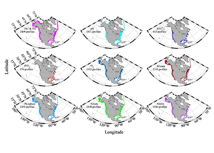
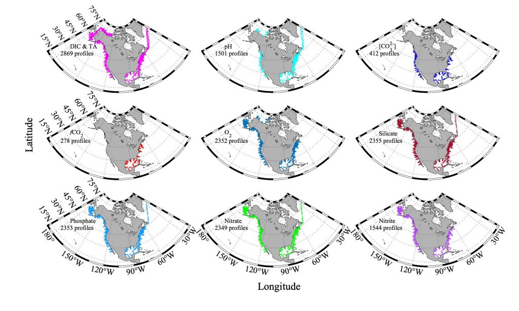
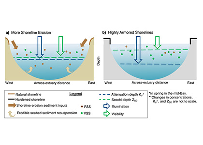
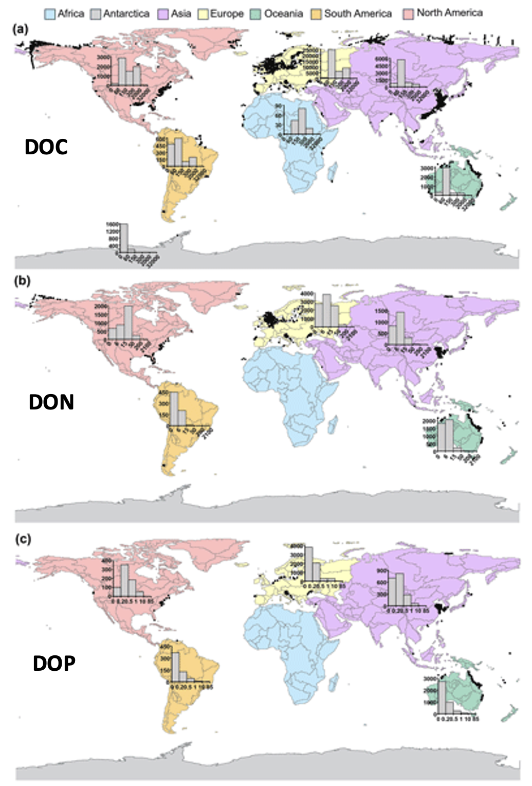
We present the first edition of a global database (CoastDOM v1) and a resulting data manuscript, which compiles previously published and unpublished measurements of DOC, DON, and DOP in coastal waters, consisting of 62,338 (DOC), 20,356 (DON), and 13,533 (DOP) data points, respectively.

CoastDOM v1 includes observations of concentrations from all continents between 1978 and 2022. However, most data were collected in the Northern Hemisphere, with a clear gap in DOM measurements from the Southern Hemisphere.

This dataset will be useful for identifying global spatial and temporal patterns in DOM and will help facilitate the reuse of DOC, DON, and DOP data in studies aimed at better characterizing local biogeochemical processes; closing nutrient budgets; estimating carbon, nitrogen, and phosphorous pools; and establishing a baseline for modelling future changes in coastal waters.

The aim is to publish an updated version of the database periodically to determine global trends of DOM levels in coastal waters, and so if you have DOM data lying around, please submit it to Christian Lønborg (c.lonborg@ecos.au.dk).

CITATIONS

Lønborg et al. 2024. A global database of dissolved organic matter (DOM) concentration measurements in coastal waters (CoastDOM v1), Earth Syst. Sci. Data, 16, 1107–1119, https://doi.org/10.5194/essd-16-1107-2024

Lønborg et al. 2023.A global database of dissolved organic matter (DOM) concentration measurements in coastal waters (CoastDOM v.1). PANGAEA, https://doi.org/10.1594/PANGAEA.964012

Ocean iron fertilization may amplify pressures on marine biomass with only a limited climate benefit

Posted by hbenway 
· Friday, January 26th, 2024 

Amidst a heightened focus on the need for both drastic and immediate emissions reductions and carbon dioxide removal to limit warming to 1.5°C (IPCC, 2022), attention is returning to ocean iron fertilization (OIF) as a means of marine carbon dioxide removal (mCDR). First discussed in the early 1990s by John Martin, the concept posits that fertilization of iron-limited marine phytoplankton would lead to enhanced ocean carbon storage via a stimulation of the ocean’s biological carbon pump. However, we lack knowledge about how OIF might operate in concert with an ocean responding to climate change and what the consequences of altered nutrient consumption patterns might be for marine ecosystems, particularly for fisheries in national exclusive economic zones (EEZs). Tagliabue et al. (2023) addressed this in a recent study using state-of-the-art climate, ocean biogeochemical, and ecosystem models under a high-emissions scenario.

The study’s findings suggested that  OIF can contribute at most a few 10s of Pg of mCDR under a high-emissions climate change scenario. This is equivalent to fewer than five years of current emissions and is consistent with earlier modeling assessments. This estimate is based on the modeled representation of carbon and iron cycling and a highly efficient OIF strategy that may be difficult to achieve in practice. Enhanced surface uptake of major nutrients due to OIF also led to a drop in global net primary production, in addition to that due to climate change alone. By then coupling a complex model of upper trophic levels, the projected declines in animal biomass due to climate change were amplified by around a third due to OIF, with the most negative impacts projected to occur in the low latitude EEZs, which are already facing increasing pressures due to climate change.

This work highlights feedbacks within the ocean’s biogeochemical and ecological systems in response to OIF that emerged over large spatial and temporal scales. Associated pressures on marine ecosystems pose major challenges for proposed management and monitoring. Restricting OIF to the highest latitudes of the Southern Ocean might mitigate some of these negative effects, but this only further reduces the minor mCDR benefit, suggesting that OIF may not make a significant contribution.

Authors
A. Tagliabue (Univ. Liverpool)
B. S. Twining (Bigelow Laboratory)
N. Barrier & O. Maury (MARBEC, IRD, IFREMER, CNRS, Université de Montpellier, France)
M. Berger & Laurent Bopp (ENS-LMD, Paris, France)

IPCC. Summary for Policymakers. in Climate Change, 2022: Mitigation of Climate Change. Contribution of Working Group III to the Sixth Assessment Report of the Intergovernmental Panel on Climate Change (eds. Shukla, P. R. et al.) (Cambridge University Press, 2022).

Fishing Vessel Ocean Observing Network (FVON) reimagines the global data collection paradigm

Posted by mmaheigan 
· Friday, December 1st, 2023 

With an increasingly wide variety of technology and innovations, from buoys to satellites, we now understand the open ocea n better than ever. Yet, existing technologies cannot cost-effectively provide accurate, up-to-date data on coastal and shelf ocean environments, especially beneath the surface. These dynamic regions impact billions of people in profound and varied ways.

Figure caption: Alongside other major global ocean observing technologies and networks, the Fishing Vessel Ocean Observing Network is built around the concept of “fishing for data” to collect high-quality ocean data such as temperature and salinity profiles. These measurements inform critical policy decisions, are integrated into sustainability efforts for fishers, scientists, and other relevant stakeholders, and can improve climate resiliency while protecting the health, well-being, and livelihoods of coastal communities and participants in the blue economy.

As described in a recent publication, the Fishing Vessel Ocean Observing Network (FVON) is reimagining the global data collection paradigm of coastal and shelf oceans by partnering with fishers and regional observation networks around the world. With more than four million fishing vessels worldwide, fishers cover much of the data-sparse nearshore ocean environments, vitally important regions of the ocean. By outfitting sensors onto vessels and on fishing gear, programs from New Zealand to Japan to New England, including researchers at WHOI, demonstrate that fishers can participate actively in the ongoing data revolution and eliminate critical oceanic data gaps without changing their standard fishing activities. Exponentially increasing the scale of data collection through fishing vessel and gear-based observations in nearshore marine environments has and will continue to democratize ocean observation, improve weather forecasting and ocean monitoring, and promote sustainable fishing while safeguarding lives and livelihoods. Already a proven concept regionally, FVON, alongside fishers and regional observation networks, will expand fishing-based observation to a global initiative.


Authors
Cooper Van Vranken (Ocean Data Network)
Julie Jakoboski (MetOcean Solutions, New Zealand)
John W. Carroll (Ocean Data Network)
Christopher Cusack (Environmental Defense Fund)
Patrick Gorringe (Swedish Meteorological and Hydrological Institute)
Naoki Hirose (Kyushu University, Japan)
James Manning (NOAA Northeast Fisheries Science Center (retired))
Michela Martinelli (National Research Council−Institute of Marine Biological Resources and Biotechnologies, Italy)
Pierluigi Penna (National Research Council−Institute of Marine Biological Resources and Biotechnologies, Italy)
Mathew Pickering (Environmental Defense Fund)
A. Miguel Piecho-Santos (Portuguese Institute for Sea and Atmosphere)
Moninya Roughan (University of New South Wales, Australia)
João de Souza (MetOcean Solutions, New Zealand)
Hassan Moustahfid (NOAA Integrated Ocean Observing System (IOOS))

Want to improve the spatiotemporal coverage of coastal water clarity? This approach combines high-resolution satellite data with low-cost in situ methods

Posted by mmaheigan 
· Friday, December 1st, 2023 

To maintain marine ecosystem health and human well-being, it is important to understand coastal water quality changes. Water clarity is a key­ component of water quality, which can be measured in situ by tools such as Secchi disks or by satellites with high spatial and temporal coverage. Coastal environments pose unique challenges to remote sensing, sometimes resulting in inaccurate estimates of water clarity.

Figure caption: Maps of model-corrected Landsat-8 derived Secchi depths from monthly clear sky images (2019–2021).

In this study, we couple low-cost in situ methods (Secchi disk depths) with open-access, high-resolution satellite (Landsat-8 and Sentinel-2) data to improve estimates of water clarity in a shallow, turbid lagoon in Virginia, USA. Our model allows the retrieval of water clarity data across an entire water body and when field measurements are unavailable. This approach can be implemented in dynamic coastal water bodies with limited in situ measurements (e.g., as part of routine water quality monitoring). This can improve our understanding of water clarity changes and their drivers to better predict how water quality may change in the future. Improved water clarity predictions can lead to better coastal ecosystem management and human well-being.

Figure caption: Workflow for obtaining Secchi disk depth with l2gen in NASA SeaDAS, bio-optical algorithms, and empirical adjustments.

Authors
Sarah E. Lang (University of Rhode Island’s Graduate School of Oceanography)
Kelly M.A. Luis (Jet Propulsion Laboratory, California Institute of Technology)
Scott C. Doney (University of Virginia)
Olivia Cronin-Golomb (University of Virginia)
Max C.N. Castorani (University of Virginia)


Twitter / Mastodon
@sarah_langsat8 on Twitter
@kelly_luis1 on Twitter
@scottdoney@universeodon.com on Mastodon
@ocronin_golomb on Twitter
@MaxCastorani on Twitter

Nutrient management improves hypoxia in the Chesapeake Bay despite record-breaking precipitation and warming

Posted by mmaheigan 
· Friday, August 26th, 2022 

Hypoxia is currently one of the greatest threats to coastal and estuarine ecosystems around the world, and this threat is projected to get worse as waters warm and human populations continue to increase. Over the past 35-years, a massive effort has been underway to decrease hypoxia in the Chesapeake Bay by reducing nutrient input from land. Despite this effort, record-breaking precipitation in 2018-2019 fueled particularly large hypoxic volumes in the Bay, calling into question the efficacy of management actions.

Figure 1. The number of days of additional hypoxia (O2 < 3 mg L-1) that would have occurred in the Chesapeake Bay if the 35 years of nutrient reductions never occurred, as calculated by differences between a realistic numerical model simulation and one with 1985 nitrogen levels. This management effort has had the greatest impact at the northern and southern edges of the hypoxia in the Bay, where there would have been an additional 60-90 days of O2 < 3 mg L-1 if nutrient reductions never occurred.

In a recent paper published in Science of the Total Environment, researchers used empirical and numerical modeling to quantify the impact of nutrient management efforts on hypoxia in the Chesapeake Bay. Results suggest that if the nutrient reduction efforts beginning in 1985 had not taken place, hypoxia would have been ~50–120% greater during the average discharge years of 2016–2017 and ~20–50% greater during the wet years of 2018–2019. The management impact was most pronounced in regions of the Bay where the hypoxia season would have been 60-90 days longer if nutrient reductions did not occur (Figure 1).

Although these results suggest that management has reduced hypoxic conditions in the Bay, additional analysis revealed that warming temperatures have already offset 6-34% of this improvement. This highlights the importance of factoring in climate change when setting future management goals.

Figure 2. The number of days of additional hypoxia (O2 < 3 mg L-1) that would have occurred in the Chesapeake Bay if the 35 years of nutrient reductions never occurred, as calculated by differences between a realistic numerical model simulation and one with 1985 nitrogen levels. This management effort has had the greatest impact at the northern and southern edges of the hypoxia in the Bay, where there would have been an additional 60-90 days of O2 < 3 mg L-1 if nutrient reductions never occurred.


Authors:
Luke T. Frankel (Virginia Institute of Marine Science, William & Mary)
Marjorie A. M. Friedrichs (Virginia Institute of Marine Science, William & Mary)
Pierre St-Laurent (Virginia Institute of Marine Science, William & Mary)
Aaron J. Bever (Anchor QEA)
Romuald N. Lipcius (Virginia Institute of Marine Science, William & Mary)
Gopal Bhatt (Pennsylvania State University; Chesapeake Bay Program)
Gary W. Shenk (USGS; Chesapeake Bay Program)

Carbon fluxes in the coastal ocean: Synthesis, boundary processes and future trends

Posted by mmaheigan 
· Friday, August 26th, 2022 

A vital part of mitigating climate change is the coastal and open ocean carbon sink, without this, it is not possible to meet the target set by the Paris Agreement. More research is needed to better understand the ocean carbon cycle and its future role in the uptake of anthropogenic carbon. A review provides an analysis of the current qualitative and quantitative understanding of the coastal ocean carbon cycle at regional to global scales, with a focus on the air-sea CO2 exchange. It includes novel findings obtained using the full breadth of methodological approaches, from observation-based studies and advanced statistical methods to conceptual and theoretical frameworks, and numerical modeling.

Figure 1: Updated sea-air CO2 flux density (mol C m−2 year−1) in the global coastal oceans that reveals that the global coastal ocean is an integrated CO2 sink with the strongest CO2 uptake at high latitudes. The challenges associated with identifying current and projected responses of the coastal ocean and it source/sink role in the global carbon budget require observational networks that are coordinated and integrated with modeling programs; development of this capability is a priority for the ocean carbon research and management communities.

Based on a new quantitative synthesis of air-sea CO2 exchange, this study yields an estimate for the globally integrated coastal ocean CO2 flux of −0.25 ± 0.05 Pg C year−1, with polar and subpolar regions accounting for most of the CO2 removal (>90%). A framework that classifies river-dominated ocean margin (RiOMar) and ocean-dominated margin (OceMar) systems is used in to conceptualize coastal carbon cycle processes. Ocean carbon models are reviewed in terms of the ability to simulate key processes and project future changes in different continental shelf regions. Concurrent trends and changes in the land-ocean-atmosphere coupled system introduce large uncertainties into projections of ocean carbon fluxes, in particular into defining the role of the coastal carbon sink and its evolution, both of which are of fundamental importance to climate science and climate policies developed before and after achievement of net-zero CO2 emissions. The major gaps and challenges identified for current coastal ocean carbon research have important implications for climate and sustainability policies. This study is a contribution to the Regional Carbon Cycle Assessment and Processes Phase 2 supported by the Global Carbon Project.


Authors:
M. H. Dai, J. Z. Su, Y. Y. Z., E. E. Hofmann, Z. M. Cao, W.-J. Cai, J. P. Gan, F. Lacroix, G. G. Laruelle, F. F. Meng, J. D. Müller, P. A.G. Regnier, G. Z. Wang, and Z. X. Wang

What drives decadal changes in the Chesapeake Bay carbonate system?

Posted by mmaheigan 
· Tuesday, May 3rd, 2022 

Understanding decadal changes in the coastal carbonate system (CO2-system) is essential for predicting how the health of these waters is affected by anthropogenic drivers, such as changing atmospheric conditions and terrestrial inputs. However, studies that quantify the relative impacts of these drivers are lacking.

A recent study in Journal of Geophysical Research: Oceans identified the primary drivers of acidification in the Chesapeake Bay over the past three decades. The authors used a three-dimensional hydrodynamic-biogeochemistry model to quantify the relative impacts on the Bay CO2-system from increases in atmospheric CO2, temperature, oceanic dissolved inorganic carbon (DIC) concentrations, terrestrial loadings of total alkalinity (TA) and DIC, as well as decreases in terrestrial nutrient inputs. Decadal changes in the surface CO2-system in the Chesapeake Bay exhibit large spatial and seasonal variability due to the combination of influences from the land, ocean and atmosphere. In the upper Bay, increased riverine TA and DIC from the Susquehanna River have increased surface pH, with other drivers only contributing to decadal changes that are one to two orders of magnitude smaller. In the mid- and lower Bay, higher atmospheric CO2 concentrations and reduced nutrient loading are the two most critical drivers and have nearly equally reduced surface pH in the summer. These decadal changes in surface pH show significant seasonal variability with the greatest magnitude generally aligning with the spring and summer shellfish production season (Figure 1).

Figure 1: Overall changes in modeled surface pH (ΔpHall) due to all global and terrestrial drivers combined over the past 30 years (i.e., 2015–2019 relative to 1985–1989). ΔpHall includes changes in surface pH due to increased atmospheric CO2, increased atmospheric thermal forcing, increased oceanic dissolved inorganic carbon concentrations, decreased riverine nitrate concentrations, decreased riverine organic nitrogen concentrations, and increased riverine total alkalinity and dissolved inorganic carbon concentrations.


These results indicate that a number of global and terrestrial drivers play crucial roles in coastal acidification. The combined effects of the examined drivers suggest that calcifying organisms in coastal surface waters are likely facing faster decreasing rates of pH than those in open ocean ecosystems. Decreases in surface pH associated with nutrient reductions highlight that the Chesapeake Bay ecosystem is returning to a more natural condition, e.g., a condition when anthropogenic nutrient input from the watershed was lower. However, increased atmospheric CO2 is simultaneously accelerating the rate of change in pH, exerting increased stress on estuarine calcifying organisms. For ecosystems such as the Chesapeake Bay where nutrient loading is already being managed, controlling the emissions of anthropogenic CO2 globally becomes increasingly important to decelerate the rate of acidification and to relieve the stress on estuarine calcifying organisms. Future observational and modeling studies are needed to further investigate how the decadal trends in the Chesapeake Bay CO2-system may vary with depth. These efforts will improve our current understanding of long-term change in coastal carbonate systems and their impacts on the shellfish industry.


Authors:
Fei Da (Virginia Institute of Marine Science, William & Mary, USA)
Marjorie A. M. Friedrichs (Virginia Institute of Marine Science, William & Mary, USA)
Pierre St-Laurent (Virginia Institute of Marine Science, William & Mary, USA)
Elizabeth H. Shadwick (CSIRO Oceans and Atmosphere, Australia)
Raymond G. Najjar (The Pennsylvania State University, USA)
Kyle E. Hinson (Virginia Institute of Marine Science, William & Mary, USA)

Introducing the Coastal Ocean Data Analysis Product in North America (CODAP-NA)

Posted by mmaheigan 
· Friday, October 22nd, 2021 

Coastal ecosystems are hotspots for commercial and recreational fisheries, and aquaculture industries that are susceptible to change or economic loss due to ocean acidification. These coastal ecosystems support about 90% of the global fisheries yield and 80% of the known marine fish species, and sustain ecosystem services worth $27.7 Trillion globally (a number larger than the U.S. economy). Despite the importance of these areas and economies, internally-consistent data products for water column carbonate and nutrient chemistry data in the coastal ocean—vital to understand and predict changes in these systems—currently do not exist. A recent study published in Earth Syst. Sci. Data compiled and quality controlled discrete sampling-based data—inorganic carbon, oxygen, and nutrient chemistry, and hydrographic parameters collected from the entire North American ocean margins—to create a data product called the Coastal Ocean Data Analysis Product for North America (CODAP-NA) to fill the gap. This effort will promote future OA research, modeling, and data synthesis in critically important coastal regions to help advance the OA adaptation, mitigation, and planning efforts by North American coastal communities; and provides a foothold for future synthesis efforts in the coastal environment.

Figure caption. Sampling stations of the CODAP-NA data product.


Authors:
Li-Qing Jiang (University of Maryland; NOAA NCEI)
Richard A. Feely (NOAA PMEL)
Rik Wanninkhof (NOAA AOML)
Dana Greeley (NOAA PMEL)
Leticia Barbero (University of Miami; NOAA AOML)
Simone Alin (NOAA PMEL)
Brendan R. Carter (University of Washington; NOAA PMEL)
Denis Pierrot (NOAA AOML)
Charles Featherstone (NOAA AOML)
James Hooper (University of Miami; NOAA AOML)
Chris Melrose (NOAA NEFSC)
Natalie Monacci (University of Alaska Fairbanks)
Jonathan Sharp (University of Washington; NOAA PMEL)
Shawn Shellito (University of New Hampshire)
Yuan-Yuan Xu (University of Miami; NOAA AOML)
Alex Kozyr (University of Maryland; NOAA NCEI)
Robert H. Byrne (University of South Florida)
Wei-Jun Cai (University of Delaware)
Jessica Cross (NOAA PMEL)
Gregory C. Johnson (NOAA PMEL)
Burke Hales (Oregon State University)
Chris Langdon (University of Miami)
Jeremy Mathis (Georgetown University)
Joe Salisbury (University of New Hampshire)
David W. Townsend (University of Maine)

Extreme events are accelerating coastal carbon cycling

Posted by mmaheigan 
· Monday, March 1st, 2021 

The world is getting stormier, and recent evidence shows significant impacts on coastal carbon cycling. The upticks in extreme weather events such as tropical cyclones have resulted in enhanced delivery of nutrients and organic matter across the land-ocean continuum. Lagoonal estuaries such as the Albemarle-Pamlico Sound (APS) in North Carolina and Galveston Bay in Texas are key coastal environments in which we can observe the long-term carbon cycling consequences of these events. Residence times of these coastal environments are on the order of months to over a year, providing ample opportunity for biogeochemical processing. Emerging from studies of Atlantic and Gulf of Mexico hurricanes in 2016 and 2017 is a clear example of the role of terrestrial dissolved organic carbon (DOC) as a key reactant driving the observed carbon cycling and ecosystem effects ( Figure 1).

Figure. 1. The impact of hurricanes on CO2 fluxes (top) and terrestrial DOC decay constants (bottom) demonstrate the sustained effect on the coastal carbon cycle caused by extreme weather events. Top panel shows results from Hurricane Matthew in 2016, where date is month and day and Km downstream represents observations taken along the main axis of the Neuse River Estuary and lower Pamlico Sound, eastern North Carolina. FCO2 is the daily sea-to-air flux of CO2 estimated from measurements of temperature, salinity, dissolved inorganic carbon, and wind speed. The results indicate the Sound existed as a weak yet sustained CO2 source to the atmosphere well after the storm. Outgassing of CO2 is driven by the rapid mineralization of terrestrial DOC. Bottom panel shows the high bioreactivity of flood-derived terrestrial DOC indicated by elevated microbial decay constants for Galveston Bay and the coastal Gulf of Mexico in 2017 as compared to high and low latitude coastal environments.

In coastal North Carolina, 36 tropical cyclones (TCs), including three floods of historical significance in the past two decades, have occurred in the past 20 years. The lingering effects of these storms include extensive periods of carbon dioxide (CO2) supersaturation. For example, Hurricane Matthew in 2016 caused the lower Pamlico Sound to emit CO2 for months after the passage of the storm. With similar results documented for the Pamlico Sound for storms in 2011 and 2012, there is solid evidence that shifts in the ecosystem state of this mesotrophic estuary from net autotrophic to net heterotrophic are a major effect of this process.

Reactive DOC from the landscape appears to be driving the shift in ecosystem state.  Large plumes of brown-colored DOC are observable from space in numerous satellite images of the Atlantic and Gulf coasts following these storms. The color is part of a phenomenon known as “coastal darkening"—spectroscopic, stable isotopic, and biomarker evidence show this darkening is related to the flushing of wetlands in the flood-plain adjacent to the rivers draining into these estuaries.

Along the Texas coast, Hurricane Harvey produced the largest rainfall event recorded in US history and caused extensive flooding in 2017. Similar to results from coastal North Carolina, flood-derived terrestrial DOC in Galveston Bay exhibited high bioreactivity, with decay constants exceeding those observed for terrestrial DOC across coastal environments from high and low latitudes by almost three-fold. The rapid processing of terrestrial DOC was linked to an active microbial community capable of decomposing aromatic compounds that are abundant in colored DOC as indicated by genomic analyses. These recent studies clearly demonstrate the impacts of large storm events on coastal carbon cycling via the transport of reactive terrestrial DOC into coastal waters. Climate-driven increases in the frequency and intensity of such storm events warrant more sustained capacity to monitor episodic deliveries of carbon and nutrients and their impacts on coastal marine ecosystems.


Authors:
Chris Osburn (North Carolina State University) @closburn
Hans Paerl (University of North Carolina, Institute of Marine Sciences)
Ge Yan (Institute of Deep-Sea Science and Engineering, Chinese Academy of Sciences)
Karl Kaiser (Texas A&M University, Galveston Campus)


Citations:

Yan, G., Labonté, J. M., Quigg, A., & Kaiser, K. (2020). Hurricanes accelerate dissolved organic carbon cycling in coastal ecosystems. Frontiers in Marine Science, 7, 248.

Osburn, C. L., Rudolph, J. C., Paerl, H. W., Hounshell, A. G., & Van Dam, B. R. (2019). Lingering carbon cycle effects of Hurricane Matthew in North Carolina's coastal waters. Geophysical Research Letters, 46(5), 2654-2661.

Counterintuitive effects of shoreline armoring on estuarine water clarity

Posted by mmaheigan 
· Wednesday, February 24th, 2021 

Around the world, human-altered shorelines change sediment inputs to estuaries and coastal waters, altering water clarity, especially in areas of dense human population. The Chesapeake Bay estuary is recovering from historically high nutrient and sediment inputs, but water clarity improvement has been ambiguous. Long-term trends show increasing water clarity in terms of deepening light attenuation depth, yet degrading clarity in terms of shallowing Secchi depth over time. High water clarity is needed to support seagrass meadows, which act as nursery habitats for commercially important fish species such as striped bass. How are these opposing water clarity trends possible?

In a recent paper published in Science of the Total Environment, researchers performed experiments with a coupled hydrodynamic-biogeochemical model to test a simulated Chesapeake Bay under realistic conditions, more shoreline erosion, and highly armored shorelines. Comparing the two extreme conditions (Figure 1), there was a striking difference between (a) an estuary experiencing more shoreline erosion and greater resuspension versus (b) a highly armored estuary with decreased resuspension. Reduced erosion yielded improved water clarity in terms of light attenuation depth, but a shallower Secchi depth (reduced visibility). In estuaries, reducing sediment inputs is often proposed as a strategy for improving water quality. This study shows that, under certain conditions in a productive estuary, reduced sediments can have unintended secondary effects on water clarity due to enhanced production of organic particles. This study also highlights the need to consider other sediment sources in addition to rivers, such as seabed resuspension and shoreline erosion, especially at times and locations of low river input.

Figure 1. Schematic of how shoreline armoring causes deepening light attenuation depth (navy) yet shallowing Secchi depth (green) during the spring growing season in the mid-bay central channel.

Authors:
Jessica S. Turner
Pierre St-Laurent
Marjorie A. M. Friedrichs
Carl T. Friedrichs
(all Virginia Institute of Marine Science)


Next Page »

Filter by Keyword

abundance acidification additionality advection africa air-sea air-sea interactions algae alkalinity allometry ammonium AMO AMOC anoxic Antarctic Antarctica anthro impacts anthropogenic carbon anthropogenic impacts appendicularia aquaculture aquatic continuum aragonite saturation arctic Argo argon arsenic artificial seawater Atlantic atmospheric CO2 atmospheric nitrogen deposition authigenic carbonates autonomous platforms bacteria bathypelagic BATS BCG Argo benthic bgc argo bio-go-ship bio-optical bioavailability biogeochemical cycles biogeochemical models biogeochemistry Biological Essential Ocean Variables biological pump biophysics bloom blue carbon bottom water boundary layer buffer capacity C14 CaCO3 calcification calcite carbon carbon-climate feedback carbon-sulfur coupling carbonate carbonate system carbon budget carbon cycle carbon dioxide carbon export carbon fluxes carbon sequestration carbon storage Caribbean CCA CCS changing marine chemistry changing marine ecosystems changing marine environments changing ocean chemistry chemical oceanographic data chemical speciation chemoautotroph chesapeake bay chl a chlorophyll circulation CO2 coastal and estuarine coastal darkening coastal ocean cobalt Coccolithophores commercial community composition competition conservation cooling effect copepod copepods coral reefs CTD currents cyclone daily cycles data data access data assimilation database data management data product Data standards DCM dead zone decadal trends decomposers decomposition deep convection deep ocean deep sea coral denitrification deoxygenation depth diatoms DIC diel migration diffusion dimethylsulfide dinoflagellate dinoflagellates discrete measurements distribution DOC DOM domoic acid DOP dust DVM ecology economics ecosystem management ecosystems eddy Education EEZ Ekman transport emissions ENSO enzyme equatorial current equatorial regions ESM estuarine and coastal carbon fluxes estuary euphotic zone eutrophication evolution export export fluxes export production extreme events faecal pellets fecal pellets filter feeders filtration rates fire fish Fish carbon fisheries fishing floats fluid dynamics fluorescence food webs forage fish forams freshening freshwater frontal zone functional role future oceans gelatinous zooplankton geochemistry geoengineering geologic time GEOTRACES glaciers gliders global carbon budget global ocean global warming go-ship grazing greenhouse gas greenhouse gases Greenland ground truthing groundwater Gulf of Maine Gulf of Mexico Gulf Stream gyre harmful algal bloom high latitude human food human impact human well-being hurricane hydrogen hydrothermal hypoxia ice age ice cores ice cover industrial onset inland waters in situ inverse circulation ions iron iron fertilization iron limitation isotopes jellies katabatic winds kelvin waves krill kuroshio lab vs field land-ocean continuum larvaceans lateral transport LGM lidar ligands light light attenuation lipids low nutrient machine learning mangroves marine carbon cycle marine heatwave marine particles marine snowfall marshes mCDR mechanisms Mediterranean meltwater mesopelagic mesoscale mesoscale processes metagenome metals methane methods microbes microlayer microorganisms microplankton microscale microzooplankton midwater mitigation mixed layer mixed layers mixing mixotrophs mixotrophy model modeling model validation mode water molecular diffusion MPT MRV multi-decade n2o NAAMES NCP nearshore net community production net primary productivity new ocean state new technology Niskin bottle nitrate nitrogen nitrogen cycle nitrogen fixation nitrous oxide north atlantic north pacific North Sea nuclear war nutricline nutrient budget nutrient cycles nutrient cycling nutrient limitation nutrients OA observations ocean-atmosphere ocean acidification ocean acidification data ocean alkalinity enhancement ocean carbon storage and uptake ocean carbon uptake and storage ocean color ocean modeling ocean observatories ocean warming ODZ oligotrophic omics OMZ open ocean optics organic particles oscillation outwelling overturning circulation oxygen pacific paleoceanography PAR parameter optimization parasite particle flux particles partnerships pCO2 PDO peat pelagic PETM pH phenology phosphate phosphorus photosynthesis physical processes physiology phytoplankton PIC piezophilic piezotolerant plankton POC polar polar regions policy pollutants precipitation predation predator-prey prediction pressure primary productivity Prochlorococcus productivity prokaryotes proteins pteropods pycnocline radioisotopes remineralization remote sensing repeat hydrography residence time resource management respiration resuspension rivers rocky shore Rossby waves Ross Sea ROV salinity salt marsh satellite scale seafloor seagrass sea ice sea level rise seasonal seasonality seasonal patterns seasonal trends sea spray seawater collection seaweed secchi sediments sensors sequestration shelf ocean shelf system shells ship-based observations shorelines siderophore silica silicate silicon cycle sinking sinking particles size SOCCOM soil carbon southern ocean south pacific spatial covariations speciation SST state estimation stoichiometry subduction submesoscale subpolar subtropical sulfate surf surface surface ocean Synechococcus technology teleconnections temperate temperature temporal covariations thermocline thermodynamics thermohaline thorium tidal time-series time of emergence titration top predators total alkalinity trace elements trace metals trait-based transfer efficiency transient features trawling Tris trophic transfer tropical turbulence twilight zone upper ocean upper water column upwelling US CLIVAR validation velocity gradient ventilation vertical flux vertical migration vertical transport warming water clarity water mass water quality waves weathering western boundary currents wetlands winter mixing zooplankton

Copyright © 2025 - OCB Project Office, Woods Hole Oceanographic Institution, 266 Woods Hole Rd, MS #25, Woods Hole, MA 02543 USA Phone: 508-289-2838  •  Fax: 508-457-2193  •  Email: ocb_news@us-ocb.org

link to nsflink to noaalink to WHOI

Funding for the Ocean Carbon & Biogeochemistry Project Office is provided by the National Science Foundation (NSF) and the National Aeronautics and Space Administration (NASA). The OCB Project Office is housed at the Woods Hole Oceanographic Institution.