
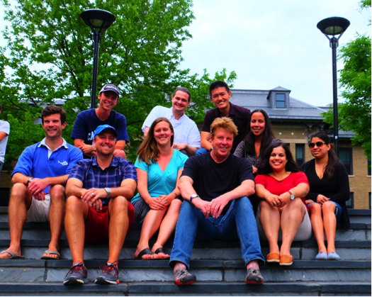
OCB-sponsored participants of the Cornell Satellite Remote Sensing Course held in June 2016 in Ithaca, NY.
 Emily Bockmon studies carbonate chemistry in the ocean, focusing on best practices for measurement and calibration of instrumentation. In 2014, she completed her PhD at Scripps Institution of Oceanography where she is currently she is working as a researcher. Next year, Emily will begin as an Assistant Professor of Chemical Oceanography at California Polytechnic State University, San Luis Obispo. She is excited to focus on the Central Californian coastal upwelling environment and the local biogeochemistry and ocean acidification.
“For me, this class really was a crash course introducing me to the world of satellite measurements and data. I am very grateful to Bruce and the TAs for their patience and facilitation of the course, as well as my amazing peers who were willing to offer trouble-shooting help and great conversation. I appreciated how much hands-on work we did, diving into various datasets and possibilities for processing them. I walked away with practical knowledge and practice in collecting and using satellite data, which is exactly what I was hoping for. I feel as though I have been exposed to a new world of data, beyond the bench chemistry I am familiar with, and I am looking forward to pairing these measurements in the future.”
 Phil Bresnahan received his PhD from Scripps Institution of Oceanography in 2015. Working in Professor Todd Martz’s lab, he developed in situ sensors to study the marine inorganic carbon system. His two main efforts involved designing a microfluidic total dissolved inorganic carbon analyzer for Argo floats and applying SeaFET/SeapHOx sensor technology in coastal ecosystems. Bresnahan is now an Environmental Scientist at the San Francisco Estuary Institute, a non-profit research organization focused on issues of mutual scientific and management-related importance in San Francisco Bay. At SFEI, he leads the efforts to characterize SF Bay’s biogeochemical variability utilizing moored sensors.
“I couldn’t speak more highly of the Cornell Satellite Remote Sensing Course. Every aspect (well, except for the cold showers—hopefully Cornell has fixed that by now!) exceeded my expectations. Bruce Monger’s teaching style was thoughtful and effective and he was a great organizer; his passion for education and remote sensing reflectance was inspiring. While my core expertise is in situ sensor development and application, I fully realize the necessity of combining multiple tools and analytical approaches. I’m excited to see what doors the course opens for me! PS: I’m processing Landsat8/OLI data using my newly acquired skills as I write this. Thanks, OCB and Bruce, for a great opportunity!”
 Dylan Catlett is a 2nd year PhD student in marine science at the University of California, Santa Barbara, and is advised primarily by Dave Siegel. Currently, his research interests lie in linking optical, chemotaxonomic, and molecular indices of phytoplankton community structure and diversity. Prior to beginning his graduate degree, he studied biology and chemistry at the University of North Carolina, Chapel Hill, where he also conducted research on the molecular responses of diatoms to iron and light limitation.
“The Satellite Remote Sensing course at Cornell was phenomenal. The course was extremely hands-on and application-oriented, making it an excellent and practical introduction to ocean color remote sensing and programming with Python. By the end of the course, I was able to comfortably obtain, process, and analyze satellite ocean color data. I returned to work after the course with much improved programming skills, which has already benefited my research immensely. The class was one of the most well organized I have ever experienced, and the instructor did a wonderful job creating a productive and fun learning environment. My fellow students led to interesting discussions, both in and outside of class, and further contributed to the educational experience. Finally, Ithaca was a joy to explore on days off. I would highly recommend this course to anyone with an interest in using ocean color remote sensing products in their research.”
 Jack Pan is a third-year PhD student working with Dr. Maria Vernet and Dr. Greg Mitchell at the Scripps Institution of Oceanography (SIO). He obtained his BS in Earth & Environmental Sciences at the University of California, Irvine, and MS in Marine Biology at SIO. Prior to enrolling at SIO, Jack worked on numerous projects at the Jet Propulsion Laboratory focusing on integrating oceanographic studies with applied sciences. In order to achieve a better understanding of the rapidly changing polar ecology and biogeochemistry, he is interested in utilizing optics-focused techniques to assimilate field measurements, remote sensing, and numerical models.
“I have gained a tremendous amount of knowledge during the Cornell Satellite Remote Sensing course in summer 2016. During this class, I learned to process and effectively utilize satellite data for my research; materials from every lecture and lab session were almost instantly helpful to my work. The course instructor, Dr. Bruce Monger, is a very kind and patient individual. He explained the material very clearly and made sure every student was doing well; and moreover, he fostered a very friendly learning environment for students to fully engage in the material and help each other to excel. Personally, I am still in contact with many of my classmates, and even formed academic collaborations with some of them. This is one of the best classes that I have ever taken, and I would highly recommend it to anyone; but more importantly, I would like to sincerely thank OCB for giving me the opportunity to attend this class.”
 Melishia Santiago is a third year PhD student in the Graduate School of Geography at Clark University. Her work focuses on the study of Arctic marine environments and the combination of in situ measurements and satellite remote sensing. She investigates chromophoric dissolved organic matter (CDOM) distribution and sea ice extent in the Bering, Chukchi, and western Beaufort seas. More generally, Melishia is interested in the biogeochemical impacts in the water column as sea ice declines in the western Arctic Ocean.
“All the skills and knowledge that I learned in the Cornell Satellite Remote Sensing course were really invaluable. The instructor and TAs were passionate about the subject. Thus, I was able to understand ocean color remote sensing concepts and apply them to my own research. It was truly a life changing experience!”
 Priya Sharma is currently a doctoral candidate at University of Pennsylvania studying “Spatiotemporal dynamics of phytoplankton biomass from ocean color remote sensing and ensemble climate model simulations.” Her research interests include assessing the evolution of phytoplankton group sizes and their functional types, ocean biological pump and response of ocean biology to various ENSO states. She completed her Master’s degree at the University of South Pacific and also worked for the Pacific Center of Environment and Sustainable Development doing oceanographic research on tropical cyclones and exploring links between climate change and social science (e.g., traditional knowledge).
“Having the amazing opportunity to attend the 2016 Cornell Satellite Remote Sensing Course has deepened my knowledge of remote sensing and optical properties. The most exciting experience for me was the processing of various levels of geophysical satellite products to obtain spatial information. This course struck an equitable balance of theoretical and hands-on practical lessons. Importantly, the data analysis tools and techniques that were taught were well aligned with my PhD thesis objectives, including empirical orthogonal function (EOF) analysis. I was also form collaborations with other participants of the course. Bruce is a very affable and approachable person, which made my experience during the Cornell course a very gratifying one.”
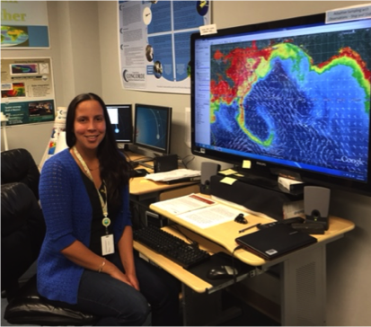 Inia M. Soto Ramos is currently a CONCORDE (Consortium in Coastal River-Dominated Ecosystems) postdoctoral researcher in the Division of Marine Science, University of Southern Mississippi at Stennis Space Center. She earned her BS in biology and education at the University of Puerto Rico, Mayaguez. She completed her MS and PhD degrees in biological oceanography at the University of South Florida. Her research interests include ocean color satellite remote sensing of coastal ecosystems, with emphasis on phytoplankton blooms and coastal ecosystems. Her current research is focused on coupling ocean color satellite imagery and high-resolution circulation models to understand the three-dimensionality of the Mississippi River Plume and the bio-optical surface response.
“The Cornell Satellite Remote Sensing Course was an outstanding experience! Dr. Bruce Monger is an exceptional professor and the course was applicable to any level of experience. Dr. Monger went the extra mile to make sure that everyone could adjust the learning experience to their own research. In my case, I have been working with satellite imagery for a few years; however I was not up to date on the technology and found myself with outdated skills. This course helped me get back on track and update my knowledge, especially my programming skills. Now, I feel much more confident with my skills and have since set up my personal computer system to integrate everything I learned during the course. I have been using the Python codes we learned during the class to process NASA’s satellite imagery for two harmful algal bloom manuscripts (in progress) and for several other projects within my group. I have no words to truly express my gratitude to Dr. Monger, the enthusiastic and motivated TAs, Cornell University, and OCB for making this opportunity a reality for me and the other 8 talented early career scientists!”
 After pursuing a BSc in Earth System Sciences at McGill University and a MSc in Earth and Ocean Sciences at the University of Victoria, Jan-Erik Tesdal began working toward a PhD in Earth and Environment Sciences at Columbia University. His broad undergraduate training emphasized a holistic view of the Earth System. Continuing in this spirit, his MSc research project focused on one of the iconic examples of how the biosphere can interact with the climate system: the CLAW hypothesis. For his PhD work, Jan-Erik narrowed his focus slightly to biological oceanography. He is especially intrigued by the interaction of the marine ecosystems with the physical environment. His current research centers on assessing the impact of melting Arctic Sea ice and freshwater flux on phytoplankton productivity and carbon export in the North Atlantic.
“The Cornell Satellite Remote Sensing course was a great experience for me. Learning the material and working through problem sets in a group setting was fun and exciting. The instructor and his TAs were very amiable and helpful, and the method-oriented teaching was ideal to help me learn the skills necessary for working with satellite data. It was especially useful to learn about the processing of satellite imagery through the conjunction of Python programming and SeaDAS. In addition to the great deal that I learned, I am very grateful for the opportunity afforded by this course to build new relationships from around the world. I can’t imagine how my current research would suffer had I not taken this course.”

