Ocean Carbon & Biogeochemistry
Studying marine ecosystems and biogeochemical cycles in the face of environmental change
  • Home
  • About OCB
    • About Us
    • Scientific Breadth
      • Biological Pump
      • Changing Marine Ecosystems
      • Changing Ocean Chemistry
      • Estuarine and Coastal Carbon Fluxes
      • Ocean Carbon Uptake and Storage
      • Ocean Observatories
    • Code of Conduct
    • Get Involved
    • Project Office
    • Scientific Steering Committee
    • OCB committees
      • Ocean Time-series
      • US Biogeochemical-Argo
      • Ocean-Atmosphere Interaction
  • Activities
    • Summer Workshop
    • OCB Webinars
    • Guidelines for OCB Workshops & Activities
    • Topical Workshops
      • CMIP6 Models Workshop
      • Coastal BGS Obs with Fisheries
      • C-saw extreme events workshop
      • Expansion of BGC-Argo and Profiling Floats
      • Fish, fisheries and carbon
      • Future BioGeoSCAPES program
      • GO-BCG Scoping Workshop
      • Lateral Carbon Flux in Tidal Wetlands
      • Leaky Deltas Workshop – Spring 2025
      • Marine CDR Workshop
      • Ocean Nucleic Acids ‘Omics
      • Pathways Connecting Climate Changes to the Deep Ocean
    • Small Group Activities
      • Aquatic Continuum OCB-NACP Focus Group
      • Arctic-COLORS Data Synthesis
      • BECS Benthic Ecosystem and Carbon Synthesis WG
      • Carbon Isotopes in the Ocean Workshop
      • CMIP6 WG
      • Filling the gaps air–sea carbon fluxes WG
      • Fish Carbon WG
      • Meta-eukomics WG
      • mCDR
      • Metaproteomic Intercomparison
      • Mixotrophs & Mixotrophy WG
      • N-Fixation WG
      • Ocean Carbonate System Intercomparison Forum
      • Ocean Carbon Uptake WG
      • OOI BGC sensor WG
      • Operational Phytoplankton Observations WG
      • Phytoplankton Taxonomy WG
    • Other Workshops
    • Science Planning
      • Coastal CARbon Synthesis (CCARS)
      • North Atlantic-Arctic
    • Ocean Acidification PI Meetings
    • Training Activities
      • PACE Hackweek 2025
      • PACE Hackweek 2024
      • PACE Training Activity 2022
  • Science Support
    • Data management and archival
    • Early Career
    • Funding Sources
    • Jobs & Postdocs
    • Meeting List
    • OCB Topical Websites
      • Ocean Fertilization
      • Trace gases
      • US IIOE-2
    • Outreach & Education
    • Promoting your science
    • Student Opportunities
    • OCB Activity Proposal Solicitations
      • Guidelines for OCB Workshops & Activities
    • Travel Support
  • Publications
    • OCB Workshop Reports
    • Science Planning and Policy
    • Newsletter Archive
  • Science Highlights
  • News

Archive for estuarine and coastal carbon fluxes

Quantifying uncertainties in future projections of Chesapeake Bay Hypoxia

Posted by mmaheigan 
· Wednesday, December 4th, 2024 

Climate change is expected to especially impact coastal zones, worsening deoxygenation in the Chesapeake Bay by reducing oxygen solubility and increasing remineralization rates of organic matter. However, simulated responses of this often fail to account for uncertainties embedded within the application of future climate scenarios.

Recent research published in Biogeosciences and in Scientific Reports sought to tackle multiple sources of uncertainty in future impacts to dissolved oxygen levels by simulating multiple climate scenarios within the Chesapeake Bay region using a coupled hydrodynamic-biogeochemical model. In Hinson et al. (2023), researchers showed that a multitude of climate scenarios projected a slight increase in hypoxia levels due solely to watershed impacts, although the choice of global earth system model, downscaling methodology, and watershed model equally contributed to the relative uncertainty in future hypoxia estimates. In Hinson et al. (2024), researchers also found that the application of climate change scenario forcings itself can have an outsized impact on Chesapeake Bay hypoxia projections. Despite using the same inputs for a set of three experiments (continuous, time slice, and delta), the more commonly applied delta method projected an increase in levels of hypoxia nearly double that of the other experiments. The findings demonstrate the importance of ecosystem model memory, and fundamental limitations of the delta approach in capturing long-term changes to both the watershed and estuary. Together these multiple sources of uncertainty interact in unanticipated ways to alter estimates of future discharge and nutrient loadings to the coastal environment.

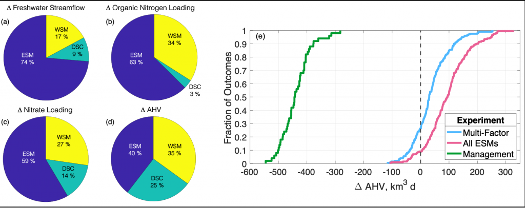
Figure 1: Chesapeake Bay hypoxia is sensitive to multiple sources of uncertainty related to the type of climate projection applied and the effect of management actions. Percent contribution to uncertainty from Earth System Model (ESM), downscaling methodology (DSC), and watershed model (WSM) for estimates of (a) freshwater streamflow, (b) organic nitrogen loading, (c) nitrate loading, and (d) change in annual hypoxic volume (ΔAHV). (e) Summary of all experiment results for ΔAHV, expressed as a cumulative distribution function. The Multi-Factor experiment (blue line) used a combination of multiple ESMs, DSCs, and WSMs, the All ESMs experiment (pink line) simulated 20 ESMs while holding the DSC and WSM constant, and the Management experiment (green line) only simulated 5 ESMs with a single DSC and WSM but incorporated reductions in nutrient inputs to the watershed. The vertical dashed black line marks no change in AHV.

Understanding the relative sources of uncertainty and impacts of environmental management actions can improve our confidence in mitigating negative climate impacts on coastal ecosystems. Better quantifying contributions of model uncertainty, that is often unaccounted for in projections, can constrain the range of outcomes and improve confidence in future simulations for environmental managers.

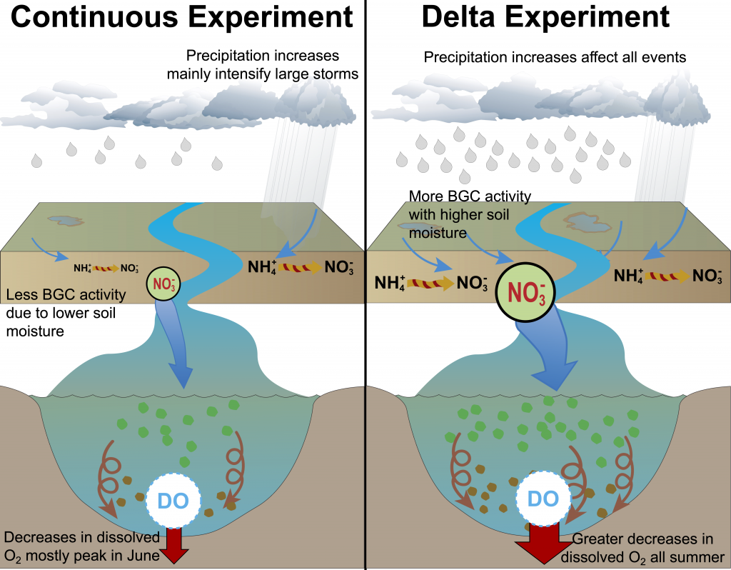
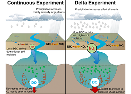
Figure 2: A schematic of differences between the Continuous and Delta experiments. In the Delta experiment a combination of altered distributions in future precipitation and changes to long-term soil nitrogen stores eventually result in increased levels of hypoxia (right panel).


Authors
Kyle E. Hinson (Virginia Institute of Marine Science, William & Mary)
Marjorie A. M. Friedrichs (Virginia Institute of Marine Science, William & Mary)
Raymond G. Najjar (The Pennsylvania State University)
Maria Herrmann (The Pennsylvania State University)
Zihao Bian (Auburn University)
Gopal Bhatt (The Pennsylvania State University, USEPA Chesapeake Bay Program Office)
Pierre St-Laurent (Virginia Institute of Marine Science, William & Mary)
Hanqin Tian (Boston College)
Gary Shenk (USGS Virginia/West Virginia Water Science Center)

Fishing Vessel Ocean Observing Network (FVON) reimagines the global data collection paradigm

Posted by mmaheigan 
· Friday, December 1st, 2023 

With an increasingly wide variety of technology and innovations, from buoys to satellites, we now understand the open ocea n better than ever. Yet, existing technologies cannot cost-effectively provide accurate, up-to-date data on coastal and shelf ocean environments, especially beneath the surface. These dynamic regions impact billions of people in profound and varied ways.

Figure caption: Alongside other major global ocean observing technologies and networks, the Fishing Vessel Ocean Observing Network is built around the concept of “fishing for data” to collect high-quality ocean data such as temperature and salinity profiles. These measurements inform critical policy decisions, are integrated into sustainability efforts for fishers, scientists, and other relevant stakeholders, and can improve climate resiliency while protecting the health, well-being, and livelihoods of coastal communities and participants in the blue economy.

As described in a recent publication, the Fishing Vessel Ocean Observing Network (FVON) is reimagining the global data collection paradigm of coastal and shelf oceans by partnering with fishers and regional observation networks around the world. With more than four million fishing vessels worldwide, fishers cover much of the data-sparse nearshore ocean environments, vitally important regions of the ocean. By outfitting sensors onto vessels and on fishing gear, programs from New Zealand to Japan to New England, including researchers at WHOI, demonstrate that fishers can participate actively in the ongoing data revolution and eliminate critical oceanic data gaps without changing their standard fishing activities. Exponentially increasing the scale of data collection through fishing vessel and gear-based observations in nearshore marine environments has and will continue to democratize ocean observation, improve weather forecasting and ocean monitoring, and promote sustainable fishing while safeguarding lives and livelihoods. Already a proven concept regionally, FVON, alongside fishers and regional observation networks, will expand fishing-based observation to a global initiative.


Authors
Cooper Van Vranken (Ocean Data Network)
Julie Jakoboski (MetOcean Solutions, New Zealand)
John W. Carroll (Ocean Data Network)
Christopher Cusack (Environmental Defense Fund)
Patrick Gorringe (Swedish Meteorological and Hydrological Institute)
Naoki Hirose (Kyushu University, Japan)
James Manning (NOAA Northeast Fisheries Science Center (retired))
Michela Martinelli (National Research Council−Institute of Marine Biological Resources and Biotechnologies, Italy)
Pierluigi Penna (National Research Council−Institute of Marine Biological Resources and Biotechnologies, Italy)
Mathew Pickering (Environmental Defense Fund)
A. Miguel Piecho-Santos (Portuguese Institute for Sea and Atmosphere)
Moninya Roughan (University of New South Wales, Australia)
João de Souza (MetOcean Solutions, New Zealand)
Hassan Moustahfid (NOAA Integrated Ocean Observing System (IOOS))

Want to improve the spatiotemporal coverage of coastal water clarity? This approach combines high-resolution satellite data with low-cost in situ methods

Posted by mmaheigan 
· Friday, December 1st, 2023 

To maintain marine ecosystem health and human well-being, it is important to understand coastal water quality changes. Water clarity is a key­ component of water quality, which can be measured in situ by tools such as Secchi disks or by satellites with high spatial and temporal coverage. Coastal environments pose unique challenges to remote sensing, sometimes resulting in inaccurate estimates of water clarity.

Figure caption: Maps of model-corrected Landsat-8 derived Secchi depths from monthly clear sky images (2019–2021).

In this study, we couple low-cost in situ methods (Secchi disk depths) with open-access, high-resolution satellite (Landsat-8 and Sentinel-2) data to improve estimates of water clarity in a shallow, turbid lagoon in Virginia, USA. Our model allows the retrieval of water clarity data across an entire water body and when field measurements are unavailable. This approach can be implemented in dynamic coastal water bodies with limited in situ measurements (e.g., as part of routine water quality monitoring). This can improve our understanding of water clarity changes and their drivers to better predict how water quality may change in the future. Improved water clarity predictions can lead to better coastal ecosystem management and human well-being.

Figure caption: Workflow for obtaining Secchi disk depth with l2gen in NASA SeaDAS, bio-optical algorithms, and empirical adjustments.

Authors
Sarah E. Lang (University of Rhode Island’s Graduate School of Oceanography)
Kelly M.A. Luis (Jet Propulsion Laboratory, California Institute of Technology)
Scott C. Doney (University of Virginia)
Olivia Cronin-Golomb (University of Virginia)
Max C.N. Castorani (University of Virginia)


Twitter / Mastodon
@sarah_langsat8 on Twitter
@kelly_luis1 on Twitter
@scottdoney@universeodon.com on Mastodon
@ocronin_golomb on Twitter
@MaxCastorani on Twitter

RPiAlk: Balancing Measurement Uncertainty and Accessibility

Posted by mmaheigan 
· Thursday, August 31st, 2023 

High-accuracy measurement of total alkalinity (TA) is crucial for our understanding of ocean acidification and the inorganic carbon complex. It is also particularly expensive in terms of labor and resources. These barriers limit its application in understudied settings such as inland waters and developing coastal regions.

To address this problem, the authors constructed an instrument using open-source and low-cost principles and wrote about it in an article published in Limnology & Oceanography: Methods. The instrument implements a standard oceanographic open-cell acidimetric titration method within Python software written to coordinate titration, data acquisition, and calculation on a Raspberry Pi platform called RPiAlk. Repeated analysis of reference materials demonstrated TA measurement precision of 3.0 μmol/kg and measurement uncertainty of 5.3 μmol/kg. This uncertainty qualifies as “weather” level uncertainty (GOA-ON 2015) and approaches “climate” level uncertainty.

We hope the accessibility of this design will aid its replication and improvement by other alkalinity-measuring laboratories, including researchers, regulators, and educators previously without access to such TA instrumentation. An expanded production of high-quality TA measurements may aid scientific understanding of understudied waters around the world.


Authors
Daniel Sandborn (University of Minnesota, Saint Paul)
Elizabeth Minor (University of Minnesota Duluth)
Craig Hill (University of Minnesota Duluth)

Mastodon: @DanielSandborn@sciencemastodon.com

Twitter: @DanielSandborn | @CraigHill_UMD


Backstory
RPiAlk came about as an artifact of instrument development in the Minor Lab at the Large Lakes Observatory. The author had been growing weary of the poor measurement repeatability of manual Gran titration (common in inland waters) and the many problems with comparison to non-linear titration curve fitting demonstrated in Dickson’s SOPs, so he decided to write a program to automate it. To the author’s delight, Dr. M. Humphreys had already written a fantastic TA calculation program, Calkulate. All that was needed was a simple wrapper and I/O function, right? Not quite. If only software and instrument development was that easy. Debugging became as tiresome as it was rewarding and educational.


Drivers of recent Chesapeake Bay warming

Posted by mmaheigan 
· Friday, August 26th, 2022 

Coastal water temperatures have been increasing globally with more frequent marine heat waves threatening marine life and nearshore communities reliant upon these ecosystems. Often, this warming is assumed to be uniform in space and time; however, this is not the case in the Chesapeake Bay, where warming waters play a major role in exacerbating low oxygen levels and indirectly limiting the efficacy of nutrient reduction efforts on land.

New research published in the Journal of the American Water Resources Association combined long-term observations and a hydrodynamic model to quantify the temporal and spatial variability in warming Chesapeake Bay waters, and identify the contributions of different mechanisms driving these historical temperature changes. While winter temperatures have warmed by less than a half a degree over the past 30 years, summer temperatures have warmed by nearly 1.5 °C, with similar increases at the surface and bottom. In cooler months, the atmosphere was the dominant driver of warming throughout the majority of the Bay, but oceanic warming explained more than half of the increased summer temperatures in the southern Bay nearest the Atlantic.

Figure 1: Relative contribution of different factors to warm-month Chesapeake Bay temperature change over the period 1985-2015. Percentages correspond to average main channel contributions for each component.

Warming temperatures have potentially significant implications for the future size of the Chesapeake Bay dead zone, and the marine species directly affected by these low oxygen conditions. Better quantifying warming contributions from the atmosphere, ocean, sea level, and rivers will also help constrain regional temperature projections throughout the estuary. More accurate projections of future Bay temperatures can help coastal managers better understand the potential for invasive species expansion and endemic species loss, impacts to fisheries and aquaculture, and how changes to ecosystem processes may impact coastal communities dependent on a healthy Bay.


Authors:
Kyle E. Hinson (Virginia Institute of Marine Science, William & Mary)
Marjorie A. M. Friedrichs (Virginia Institute of Marine Science, William & Mary)
Pierre St-Laurent (Virginia Institute of Marine Science, William & Mary)
Fei Da (Virginia Institute of Marine Science, William & Mary)
Raymond G. Najjar (The Pennsylvania State University)

Seagrass is not a silver bullet for climate change

Posted by mmaheigan 
· Friday, January 21st, 2022 

Coastal management actions aimed at protecting or restoring seagrass meadows are often assumed to have the collateral benefit of removing large amounts of carbon dioxide from the atmosphere to combat climate change. Be aware, however: not all seagrass meadows are alike. Under certain conditions, some release more carbon dioxide than they absorb and are net carbon sources to the atmosphere. This is now shown in a new study by an international team of researchers, published in the scientific journal Science Advances. This study combined direct eddy covariance measurements of air-water gas exchange with geochemical approaches to build a comprehensive carbon budget for a tropical seagrass meadow in south Florida. The process of ecosystem calcification released far more CO2 to the atmosphere than was buried in sediments as “Blue Carbon.” This study questions the reliability of Blue Carbon approaches towards net CO2 sequestration in tropical waters. But still unclear is how applicable these results are to the global scale, and what fraction of tropical seagrass meadows are net sources, rather than sinks, of CO2 to the atmosphere.

Figure 1 : Diel trend in CO2 flux presented as discrete 30-min measurements during the study period (black circles) and annual mean fluxes for the year surrounding the study period, binned in 2-hour intervals [colored circles (x ± SD)].

Authors
Bryce R. Van Dam (Helmholtz-Zentrum Hereon)
Mary A. Zeller (Leibniz Institute for Baltic Sea Research)
Christian Lopes (Florida International University)
Ashley R. Smyth (University of Florida)
Michael E. Böttcher  (Leibniz Institute for Baltic Sea Research)
Christopher L. Osburn (North Carolina State University)
Tristan Zimmerman (Helmholtz-Zentrum Hereon)
Daniel Pröfrock (Helmholtz-Zentrum Hereon)
James W. Fourqurean (Florida International University)
Helmuth Thomas  (Helmholtz-Zentrum Hereon)

Extreme events are accelerating coastal carbon cycling

Posted by mmaheigan 
· Monday, March 1st, 2021 

The world is getting stormier, and recent evidence shows significant impacts on coastal carbon cycling. The upticks in extreme weather events such as tropical cyclones have resulted in enhanced delivery of nutrients and organic matter across the land-ocean continuum. Lagoonal estuaries such as the Albemarle-Pamlico Sound (APS) in North Carolina and Galveston Bay in Texas are key coastal environments in which we can observe the long-term carbon cycling consequences of these events. Residence times of these coastal environments are on the order of months to over a year, providing ample opportunity for biogeochemical processing. Emerging from studies of Atlantic and Gulf of Mexico hurricanes in 2016 and 2017 is a clear example of the role of terrestrial dissolved organic carbon (DOC) as a key reactant driving the observed carbon cycling and ecosystem effects ( Figure 1).

Figure. 1. The impact of hurricanes on CO2 fluxes (top) and terrestrial DOC decay constants (bottom) demonstrate the sustained effect on the coastal carbon cycle caused by extreme weather events. Top panel shows results from Hurricane Matthew in 2016, where date is month and day and Km downstream represents observations taken along the main axis of the Neuse River Estuary and lower Pamlico Sound, eastern North Carolina. FCO2 is the daily sea-to-air flux of CO2 estimated from measurements of temperature, salinity, dissolved inorganic carbon, and wind speed. The results indicate the Sound existed as a weak yet sustained CO2 source to the atmosphere well after the storm. Outgassing of CO2 is driven by the rapid mineralization of terrestrial DOC. Bottom panel shows the high bioreactivity of flood-derived terrestrial DOC indicated by elevated microbial decay constants for Galveston Bay and the coastal Gulf of Mexico in 2017 as compared to high and low latitude coastal environments.

In coastal North Carolina, 36 tropical cyclones (TCs), including three floods of historical significance in the past two decades, have occurred in the past 20 years. The lingering effects of these storms include extensive periods of carbon dioxide (CO2) supersaturation. For example, Hurricane Matthew in 2016 caused the lower Pamlico Sound to emit CO2 for months after the passage of the storm. With similar results documented for the Pamlico Sound for storms in 2011 and 2012, there is solid evidence that shifts in the ecosystem state of this mesotrophic estuary from net autotrophic to net heterotrophic are a major effect of this process.

Reactive DOC from the landscape appears to be driving the shift in ecosystem state.  Large plumes of brown-colored DOC are observable from space in numerous satellite images of the Atlantic and Gulf coasts following these storms. The color is part of a phenomenon known as “coastal darkening"—spectroscopic, stable isotopic, and biomarker evidence show this darkening is related to the flushing of wetlands in the flood-plain adjacent to the rivers draining into these estuaries.

Along the Texas coast, Hurricane Harvey produced the largest rainfall event recorded in US history and caused extensive flooding in 2017. Similar to results from coastal North Carolina, flood-derived terrestrial DOC in Galveston Bay exhibited high bioreactivity, with decay constants exceeding those observed for terrestrial DOC across coastal environments from high and low latitudes by almost three-fold. The rapid processing of terrestrial DOC was linked to an active microbial community capable of decomposing aromatic compounds that are abundant in colored DOC as indicated by genomic analyses. These recent studies clearly demonstrate the impacts of large storm events on coastal carbon cycling via the transport of reactive terrestrial DOC into coastal waters. Climate-driven increases in the frequency and intensity of such storm events warrant more sustained capacity to monitor episodic deliveries of carbon and nutrients and their impacts on coastal marine ecosystems.


Authors:
Chris Osburn (North Carolina State University) @closburn
Hans Paerl (University of North Carolina, Institute of Marine Sciences)
Ge Yan (Institute of Deep-Sea Science and Engineering, Chinese Academy of Sciences)
Karl Kaiser (Texas A&M University, Galveston Campus)


Citations:

Yan, G., Labonté, J. M., Quigg, A., & Kaiser, K. (2020). Hurricanes accelerate dissolved organic carbon cycling in coastal ecosystems. Frontiers in Marine Science, 7, 248.

Osburn, C. L., Rudolph, J. C., Paerl, H. W., Hounshell, A. G., & Van Dam, B. R. (2019). Lingering carbon cycle effects of Hurricane Matthew in North Carolina's coastal waters. Geophysical Research Letters, 46(5), 2654-2661.

Counterintuitive effects of shoreline armoring on estuarine water clarity

Posted by mmaheigan 
· Wednesday, February 24th, 2021 

Around the world, human-altered shorelines change sediment inputs to estuaries and coastal waters, altering water clarity, especially in areas of dense human population. The Chesapeake Bay estuary is recovering from historically high nutrient and sediment inputs, but water clarity improvement has been ambiguous. Long-term trends show increasing water clarity in terms of deepening light attenuation depth, yet degrading clarity in terms of shallowing Secchi depth over time. High water clarity is needed to support seagrass meadows, which act as nursery habitats for commercially important fish species such as striped bass. How are these opposing water clarity trends possible?

In a recent paper published in Science of the Total Environment, researchers performed experiments with a coupled hydrodynamic-biogeochemical model to test a simulated Chesapeake Bay under realistic conditions, more shoreline erosion, and highly armored shorelines. Comparing the two extreme conditions (Figure 1), there was a striking difference between (a) an estuary experiencing more shoreline erosion and greater resuspension versus (b) a highly armored estuary with decreased resuspension. Reduced erosion yielded improved water clarity in terms of light attenuation depth, but a shallower Secchi depth (reduced visibility). In estuaries, reducing sediment inputs is often proposed as a strategy for improving water quality. This study shows that, under certain conditions in a productive estuary, reduced sediments can have unintended secondary effects on water clarity due to enhanced production of organic particles. This study also highlights the need to consider other sediment sources in addition to rivers, such as seabed resuspension and shoreline erosion, especially at times and locations of low river input.

Figure 1. Schematic of how shoreline armoring causes deepening light attenuation depth (navy) yet shallowing Secchi depth (green) during the spring growing season in the mid-bay central channel.

Authors:
Jessica S. Turner
Pierre St-Laurent
Marjorie A. M. Friedrichs
Carl T. Friedrichs
(all Virginia Institute of Marine Science)


Wildfire impacts on coastal ocean phytoplankton

Posted by mmaheigan 
· Wednesday, February 24th, 2021 

Wildfire frequency, size, and destructiveness has increased over the last two decades, particularly in coastal regions such as Australia, Brazil, and the western United States. While the impact of fire on land, plants, and people is well documented, very few studies have been able to evaluate the impact of fires on ocean ecosystems. A serendipitously planned research cruise one week after the Thomas Fire broke out in California in December 2017 allowed the authors of this study and their colleagues to sample the adjacent Santa Barbara Channel during this devastating extreme fire event.

In a recent paper published in Journal of Geophysical Research: Oceans, the authors describe the phytoplankton community in the Santa Barbara Channel during the Thomas Fire. Phytoplankton community composition was described using a combination of images of phytoplankton from the Imaging FlowCytobot (McLane Labs) and phytoplankton pigments. Dinoflagellates were the dominant phytoplankton group in the surface ocean during the Thomas Fire, according to both methods (Figure 1).

Figure 1. (A) The fraction of total particle volume imaged by the Imaging FlowCytobot (IFCB) comprised of phytoplankton (green) and detritus (brown). Example IFCB images of ash (counted as part of detritus) particles are outlined in brown. (B) The phytoplankton fraction is then further divided by taxonomy, showing the abundance of nano-sized phytoplankton and especially dinoflagellates during the week of sampling. Example IFCB images of Gonyaulax (outlined in dark green), Prorocentrum (outlined in light green), and Umbilicosphaera (outlined in purple) cells are also shown.


While this study was not able to demonstrate a causal relationship between the Thomas Fire and the presence of dinoflagellates, this result is quite different from previous winters in the Santa Barbara Channel, when picophytoplankton and diatoms typically dominate the winter community. The incidence of dinoflagellates in the Santa Barbara Channel in December 2017 was correlated with the warmer-than-average water temperature during this study, which matched observations from other areas along the Central California coast that winter.

At the time this study was conducted, the Thomas Fire was the largest wildfire in California history. Since then, California fires have increased in danger, destruction, and human mortality; the Mendocino Fire complex (summer 2018) and five separate wildfires in summer 2020 exceeded the impacts of the Thomas Fire. With wildfire severity and frequency increasing not only in California but in coastal regions worldwide, this study gives an important first look at the impact of wildfire smoke and ash on oceanic primary productivity and community composition.


Authors:
Sasha Kramer (University of California Santa Barbara)
Kelsey Bisson (Oregon State University)
Alexis Fischer (University of California Santa Cruz)

Ice sheets mobilize trace elements for export downstream

Posted by mmaheigan 
· Thursday, January 7th, 2021 

Trace elements are essential micronutrients for life in the ocean and also serve as valuable fingerprints of chemical weathering. The behaviour of trace elements in the ocean has gained interest because some of these elements are found at vanishingly low concentrations that limit ecosystem productivity. Despite delivering >2000 km3 yr-1 of freshwater to the polar oceans, ice sheets have largely been overlooked as major trace element sources. This is partly due to a lack of data on meltwater endmember chemistry beneath and emerging from the Greenland and Antarctic ice sheets, which cover 10% of Earth’s land surface area, and partly because meltwaters were previously assumed to be dilute compared to most river waters.

In a study published in PNAS, authors analysed the trace element composition of meltwaters from the Mercer Subglacial Lake, a hydrologically active subglacial lake >1000 m below the surface of the Antarctic Ice Sheet, and a meltwater river emerging from beneath a large outlet glacier of the Greenland Ice Sheet (Leverett Glacier). These subglacial meltwaters (i.e., water travelling along the ice-rock interface beneath an ice mass) contained much higher concentrations of trace elements than anticipated. For example, typically immobile elements like iron and aluminium were observed in the dissolved phase (<0.45 µm) at much higher concentrations than in mean river or open ocean waters (up to 20,900 nM for Fe and 69,100 nM for Al), but exhibited large size fractionation between colloidal/nanoparticulate (0.02 – 0.45 µm) and soluble (<0.02 µm) size fractions (Figure 1). Subglacial physical and biogeochemical weathering processes are thought to mobilize many of these trace elements from the bedrock and sediments beneath ice sheets and export them downstream. Antarctic subglacial meltwaters were more enriched in dissolved trace elements than Greenland Ice Sheet outflow, which is likely due to longer subglacial residence times, lack of dilution from surface meltwater inputs, and differences in underlying sediment geology.

These results indicate that ice sheet systems can mobilize large quantities of trace elements from the land to the ocean and serve as major contributors to regional elemental cycles (e.g., coastal Southern Ocean). In a warming climate with increasing ice sheet runoff, subglacial meltwaters will become an increasingly dynamic source of micronutrients to coastal oceanic ecosystems in the polar regions.

Figure caption: Leverett Glacier (Greenland Ice Sheet) and Mercer Subglacial Lake (Antarctic Ice Sheet) dissolved elemental concentrations (<0.45 µm) normalized to mean non-glacial riverine trace element concentrations (Gaillardet et al., 2014) and major element concentrations (Martin and Meybeck, 1979). Grey regions indicate ±50 % of the riverine mean. Although major elements can be significantly depleted compared to non-glacial rivers, trace elements are commonly similar to or enriched.


Authors:
Jon R. Hawkings (Florida State Univ and German Research Centre for Geosciences)
Mark L. Skidmore (Montana State Univ)
Jemma L. Wadham (Univ of Bristol, UK)
John C. Priscu (Montana State Univ)
Peter L. Morton (Florida State Univ)
Jade E. Hatton (Univ of Bristol, UK)
Christopher B. Gardner (Ohio State Univ)
Tyler J. Kohler (École Polytechnique Fédérale de Lausanne, Switzerland)
Marek Stibal (Charles University, Prague, Czech Republic)
Elizabeth A. Bagshaw (Cardiff Univ, UK)
August Steigmeyer (Montana State Univ)
Joel Barker (Univ of Minnesota)
John E. Dore (Montana State Univ)
W. Berry Lyons (Ohio State Univ)
Martyn Tranter (Univ of Bristol, UK)
Robert G. M. Spencer (Florida State Univ)
SALSA Science Team

Next Page »

Filter by Keyword

abundance acidification additionality advection africa air-sea air-sea interactions algae alkalinity allometry ammonium AMO AMOC anoxic Antarctic Antarctica anthro impacts anthropogenic carbon anthropogenic impacts appendicularia aquaculture aquatic continuum aragonite saturation arctic Argo argon arsenic artificial seawater Atlantic atmospheric CO2 atmospheric nitrogen deposition authigenic carbonates autonomous platforms bacteria bathypelagic BATS BCG Argo benthic bgc argo bio-go-ship bio-optical bioavailability biogeochemical cycles biogeochemical models biogeochemistry Biological Essential Ocean Variables biological pump biophysics bloom blue carbon bottom water boundary layer buffer capacity C14 CaCO3 calcification calcite carbon carbon-climate feedback carbon-sulfur coupling carbonate carbonate system carbon budget carbon cycle carbon dioxide carbon export carbon fluxes carbon sequestration carbon storage Caribbean CCA CCS changing marine chemistry changing marine ecosystems changing marine environments changing ocean chemistry chemical oceanographic data chemical speciation chemoautotroph chesapeake bay chl a chlorophyll circulation CO2 coastal and estuarine coastal darkening coastal ocean cobalt Coccolithophores commercial community composition competition conservation cooling effect copepod copepods coral reefs CTD currents cyclone daily cycles data data access data assimilation database data management data product Data standards DCM dead zone decadal trends decomposers decomposition deep convection deep ocean deep sea coral denitrification deoxygenation depth diatoms DIC diel migration diffusion dimethylsulfide dinoflagellate dinoflagellates discrete measurements distribution DOC DOM domoic acid DOP dust DVM ecology economics ecosystem management ecosystems eddy Education EEZ Ekman transport emissions ENSO enzyme equatorial current equatorial regions ESM estuarine and coastal carbon fluxes estuary euphotic zone eutrophication evolution export export fluxes export production extreme events faecal pellets fecal pellets filter feeders filtration rates fire fish Fish carbon fisheries fishing floats fluid dynamics fluorescence food webs forage fish forams freshening freshwater frontal zone functional role future oceans gelatinous zooplankton geochemistry geoengineering geologic time GEOTRACES glaciers gliders global carbon budget global ocean global warming go-ship grazing greenhouse gas greenhouse gases Greenland ground truthing groundwater Gulf of Maine Gulf of Mexico Gulf Stream gyre harmful algal bloom high latitude human food human impact human well-being hurricane hydrogen hydrothermal hypoxia ice age ice cores ice cover industrial onset inland waters in situ inverse circulation ions iron iron fertilization iron limitation isotopes jellies katabatic winds kelvin waves krill kuroshio lab vs field land-ocean continuum larvaceans lateral transport LGM lidar ligands light light attenuation lipids low nutrient machine learning mangroves marine carbon cycle marine heatwave marine particles marine snowfall marshes mCDR mechanisms Mediterranean meltwater mesopelagic mesoscale mesoscale processes metagenome metals methane methods microbes microlayer microorganisms microplankton microscale microzooplankton midwater mitigation mixed layer mixed layers mixing mixotrophs mixotrophy model modeling model validation mode water molecular diffusion MPT MRV multi-decade n2o NAAMES NCP nearshore net community production net primary productivity new ocean state new technology Niskin bottle nitrate nitrogen nitrogen cycle nitrogen fixation nitrous oxide north atlantic north pacific North Sea nuclear war nutricline nutrient budget nutrient cycles nutrient cycling nutrient limitation nutrients OA observations ocean-atmosphere ocean acidification ocean acidification data ocean alkalinity enhancement ocean carbon storage and uptake ocean carbon uptake and storage ocean color ocean modeling ocean observatories ocean warming ODZ oligotrophic omics OMZ open ocean optics organic particles oscillation outwelling overturning circulation oxygen pacific paleoceanography PAR parameter optimization parasite particle flux particles partnerships pCO2 PDO peat pelagic PETM pH phenology phosphate phosphorus photosynthesis physical processes physiology phytoplankton PIC piezophilic piezotolerant plankton POC polar polar regions policy pollutants precipitation predation predator-prey prediction pressure primary productivity Prochlorococcus productivity prokaryotes proteins pteropods pycnocline radioisotopes remineralization remote sensing repeat hydrography residence time resource management respiration resuspension rivers rocky shore Rossby waves Ross Sea ROV salinity salt marsh satellite scale seafloor seagrass sea ice sea level rise seasonal seasonality seasonal patterns seasonal trends sea spray seawater collection seaweed secchi sediments sensors sequestration shelf ocean shelf system shells ship-based observations shorelines siderophore silica silicate silicon cycle sinking sinking particles size SOCCOM soil carbon southern ocean south pacific spatial covariations speciation SST state estimation stoichiometry subduction submesoscale subpolar subtropical sulfate surf surface surface ocean Synechococcus technology teleconnections temperate temperature temporal covariations thermocline thermodynamics thermohaline thorium tidal time-series time of emergence titration top predators total alkalinity trace elements trace metals trait-based transfer efficiency transient features trawling Tris trophic transfer tropical turbulence twilight zone upper ocean upper water column upwelling US CLIVAR validation velocity gradient ventilation vertical flux vertical migration vertical transport warming water clarity water mass water quality waves weathering western boundary currents wetlands winter mixing zooplankton

Copyright © 2025 - OCB Project Office, Woods Hole Oceanographic Institution, 266 Woods Hole Rd, MS #25, Woods Hole, MA 02543 USA Phone: 508-289-2838  •  Fax: 508-457-2193  •  Email: ocb_news@us-ocb.org

link to nsflink to noaalink to WHOI

Funding for the Ocean Carbon & Biogeochemistry Project Office is provided by the National Science Foundation (NSF) and the National Aeronautics and Space Administration (NASA). The OCB Project Office is housed at the Woods Hole Oceanographic Institution.