Ocean Carbon & Biogeochemistry
Studying marine ecosystems and biogeochemical cycles in the face of environmental change
  • Home
  • About OCB
    • About Us
    • Scientific Breadth
      • Biological Pump
      • Changing Marine Ecosystems
      • Changing Ocean Chemistry
      • Estuarine and Coastal Carbon Fluxes
      • Ocean Carbon Uptake and Storage
      • Ocean Observatories
    • Code of Conduct
    • Get Involved
    • Project Office
    • Scientific Steering Committee
    • OCB committees
      • Ocean Time-series
      • US Biogeochemical-Argo
      • Ocean-Atmosphere Interaction
  • Activities
    • Summer Workshop
    • OCB Webinars
    • Guidelines for OCB Workshops & Activities
    • Topical Workshops
      • CMIP6 Models Workshop
      • Coastal BGS Obs with Fisheries
      • C-saw extreme events workshop
      • Expansion of BGC-Argo and Profiling Floats
      • Fish, fisheries and carbon
      • Future BioGeoSCAPES program
      • GO-BCG Scoping Workshop
      • Lateral Carbon Flux in Tidal Wetlands
      • Leaky Deltas Workshop – Spring 2025
      • Marine CDR Workshop
      • Ocean Nucleic Acids ‘Omics
      • Pathways Connecting Climate Changes to the Deep Ocean
    • Small Group Activities
      • Aquatic Continuum OCB-NACP Focus Group
      • Arctic-COLORS Data Synthesis
      • BECS Benthic Ecosystem and Carbon Synthesis WG
      • Carbon Isotopes in the Ocean Workshop
      • CMIP6 WG
      • Filling the gaps air–sea carbon fluxes WG
      • Fish Carbon WG
      • Meta-eukomics WG
      • mCDR
      • Metaproteomic Intercomparison
      • Mixotrophs & Mixotrophy WG
      • N-Fixation WG
      • Ocean Carbonate System Intercomparison Forum
      • Ocean Carbon Uptake WG
      • OOI BGC sensor WG
      • Operational Phytoplankton Observations WG
      • Phytoplankton Taxonomy WG
    • Other Workshops
    • Science Planning
      • Coastal CARbon Synthesis (CCARS)
      • North Atlantic-Arctic
    • Ocean Acidification PI Meetings
    • Training Activities
      • PACE Hackweek 2025
      • PACE Hackweek 2024
      • PACE Training Activity 2022
  • Science Support
    • Data management and archival
    • Early Career
    • Funding Sources
    • Jobs & Postdocs
    • Meeting List
    • OCB Topical Websites
      • Ocean Fertilization
      • Trace gases
      • US IIOE-2
    • Outreach & Education
    • Promoting your science
    • Student Opportunities
    • OCB Activity Proposal Solicitations
      • Guidelines for OCB Workshops & Activities
    • Travel Support
  • Publications
    • OCB Workshop Reports
    • Science Planning and Policy
    • Newsletter Archive
  • Science Highlights
  • News

Archive for estuarine and coastal carbon fluxes – Page 3

A synthesis of North American coastal carbon fluxes

Posted by mmaheigan 
· Tuesday, April 30th, 2019 

Carbon fluxes in the coastal ocean and across its boundaries with the atmosphere, land, and the open ocean are an important but poorly constrained component of the global carbon budget. By synthesizing available observations and model simulations, a recent study aims to answer 1) whether the coastal ocean of North America takes up atmospheric CO2 and exports carbon to the open ocean; and 2) if so, how much? The authors estimate a net carbon sink of 160±80 Tg C yr−1 in the North American Exclusive Economic Zone (EEZ) with the Arctic, sub-Arctic and mid-latitude Atlantic EEZ regions as the major contributors.

Portion of EEZ Tg C yr−1 % of the total area
Arctic and sub-Arctic 104 51%
Mid-latitude Atlantic 62 25%
Mid-latitude Pacific -3.7 24%

Table 1: Regional breakdown of estimated carbon sink in the North Atlantic EEZ (negative values imply a carbon source).


Combining the net uptake with an estimate of carbon input from land of minus estimates of burial and accumulation of dissolved carbon in EEZ waters as follows implies a carbon export of 151±105 Tg C yr−1 to the open ocean.

160±80 

Tg C yr−1

+

106±30 

Tg C yr−1

–

65±55 

Tg C yr−1

–

50±25 

Tg C yr−1

=

151±105 

Tg C yr−1

Net uptake


Carbon input from land Estimated burial Estimated accumulation DOC in EEZ waters Carbon export to open ocean (estimated C export to open ocean)


The estimated uptake of atmospheric carbon in the North American EEZ amounts to 6.4% of the global ocean uptake of atmospheric CO2 (est. 2,500 Tg C yr−1). The North American EEZ only represents ~4% of the global ocean surface area, thus the CO2 uptake is about 50% more efficient in the North American EEZ than the global average. Given the importance of coastal margins, both in contributing to carbon budgets and in the societal benefits they provide, further efforts to improve assessments of the carbon cycle in these regions are paramount. It is critical to maintain and expand existing coastal observing programs, continue national and international coordination and integration of observations, modeling capabilities, and stakeholder needs.


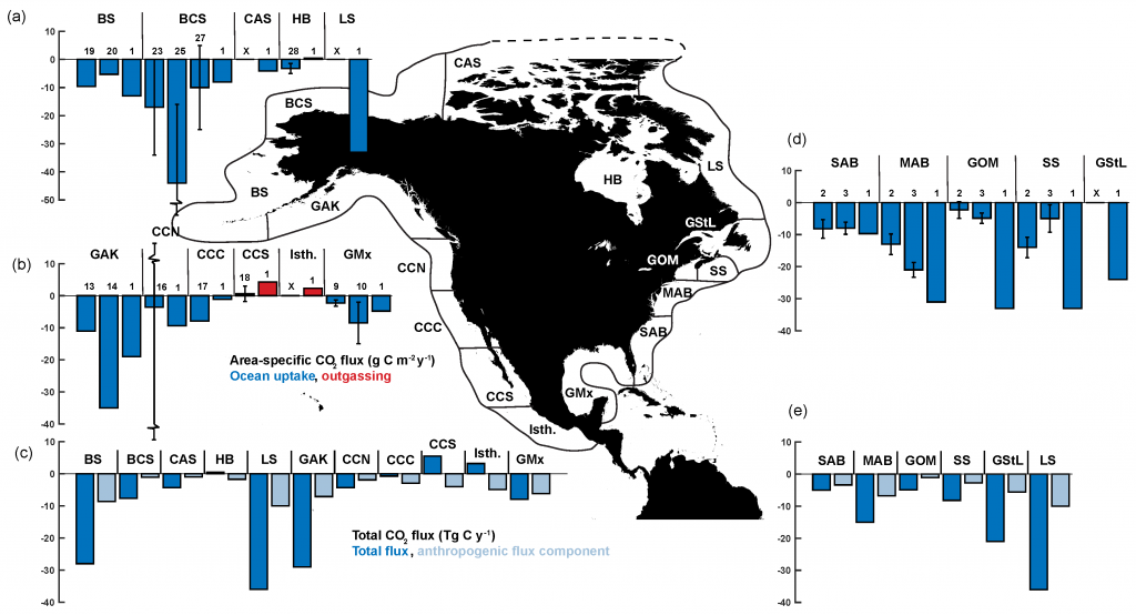
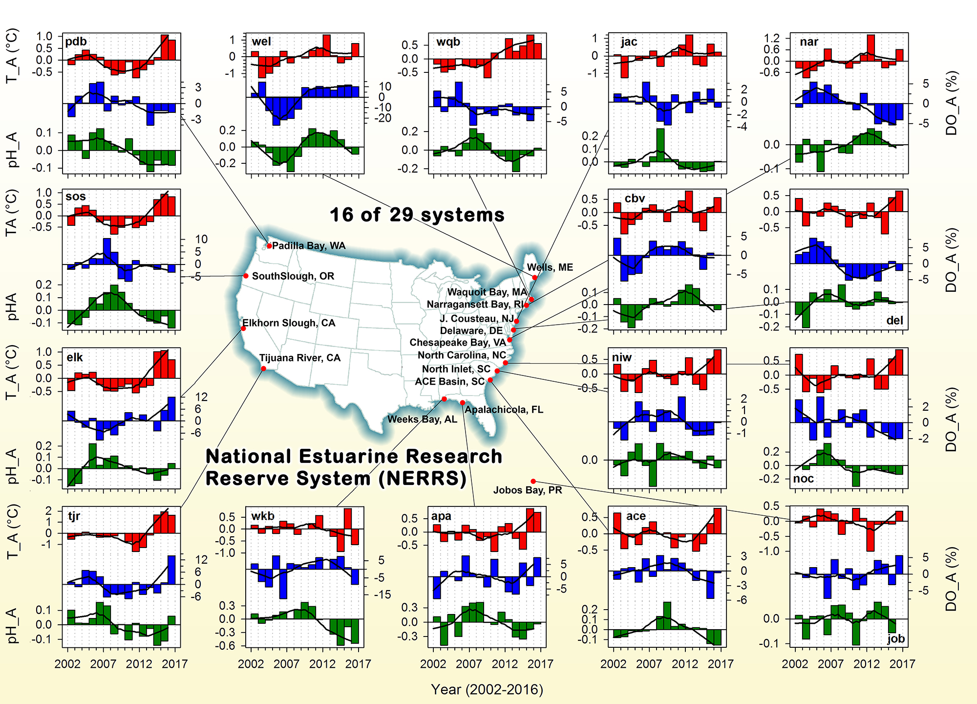
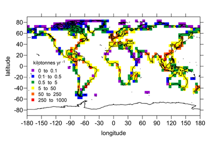
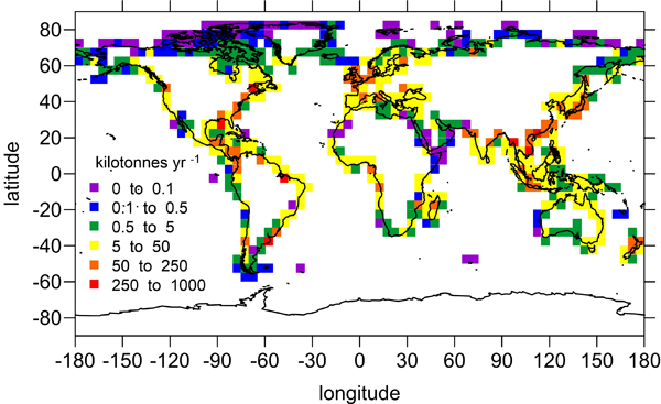
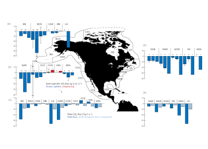
Figure: Area-specific carbon fluxes for North American coastal regions (a, b and d) and total fluxes for a decomposition of the EEZ (c, e).


Authors:
Katja Fennel, Timothée Bourgeois (Dalhousie University, Canada)
Simone Alin, Richard A. Feely, Adrienne Sutton (NOAA Pacific Marine Environmental Laboratory)
Leticia Barbero (NOAA Atlantic Oceanographic and Meteorological Laboratory)
Wiley Evans (Hakai Institute, Canada)
Sarah Cooley (Ocean Conservancy)
John Dunne (NOAA Geophysical Fluid Dynamics Laboratory)
Jose Martin Hernandez-Ayon (Autonomous University of Baja California, Mexico)
Xinping Hu (Texas A&M University)
Steven Lohrenz (University of Massachusetts, Dartmouth)
Frank Muller-Karger, Lisa Robbins (University of South Florida)
Raymond Najjar (Pennsylvania State University)
Elizabeth Shadwick (CSIRO, Australia)
Samantha Siedlecki, Penny Vlahos (University of Connecticut)
Nadja Steiner (Department of Fisheries and Oceans Canada)
Daniela Turk (Lamont-Doherty Earth Observatory)
Zhaohui Aleck Wang (Woods Hole Oceanographic Institution)

Gulf of Mexico: A blue carbon hotspot of mangroves, seagrass and marshes

Posted by mmaheigan 
· Wednesday, February 20th, 2019 

The Gulf of Mexico (GoM) is an important global hotspot that comprises over 2.1615 million hectares of blue carbon habitats, including mangroves, seagrasses, and salt marshes, which collectively store 480.5 Tg of organic carbon (Corg) just in the upper 1 meter of sediment. Some of these important areas of carbon sequestration are protected or conserved, but much of the area is vulnerable, as 69 million people (US and Mexico) live within 50 miles of these blue carbon habitats, so the potential for development and subsequent habitat loss is high. In a recent study published in Science of the Total Environment, the estuaries around the GoM were delineated to determine areal extent and associated carbon stocks for all three habitats.

Figure 1: Map of blue carbon extent and stock for six sub-regions in the Gulf of Mexico estuaries and the Florida Shelf. The areal extent in hectares (ha) and associated organic carbon (Corg) stock in Tg is listed for each blue carbon system (MN = mangroves, SG = seagrass, SM = saltmarsh) in each sub-region. The underlying blue carbon map shows the distribution of mangroves (red), saltmarsh (yellow), and seagrass (blue) (used with permission from Chmura and Short, 2015).


Of the GoM blue carbon systems studied, mangroves sequester the most carbon, storing nearly 200 Tg Corg over 650,482 ha (Figure 1). Seagrass is ubiquitous throughout the GoM basin, spanning over 1 million ha and storing 184 Tg Corg, Salt marshes, which are predominantly found in the northwestern quadrant of the GoM account for just under 100 Tg Corg. In addition to presenting these updated blue carbon stock estimates for the GoM, this study estimates anthropogenic impacts on GoM blue carbon storage and compares GoM vs. Atlantic shoreline blue carbon habitat stocks and extents.


Authors:
Anitra L. Thorhaug (Yale University)
Helen M. Poulos (Wesleyan University)
Jorge López-Portillo (Instituto de Ecología Mexico)
Jordan Barr (Elder Research)
Ana Laura Lara-Domínguez (Instituto de Ecología Mexico)
Tim C. Ku (Wesleyan University)
Graeme P.Berlyn (Yale University

Long-term coastal data sets reveal unifying relationship between oxygen and pH fluctuations

Posted by mmaheigan 
· Thursday, June 7th, 2018 

Coastal habitats are critically important to humans, but without consistent and reliable observations we cannot understand the direction and magnitude of unfolding changes in these habitats. Environmental monitoring is therefore a prescient—yet still undervalued—societal service, and no effort better exemplifies this than the work conducted within the National Estuarine Research Reserve System (NERRS). NERRS is a network of 29 U.S. estuarine sites operated as a partnership between NOAA and the coastal states. NERRS has established a system-wide monitoring program with standardized instrumentation, protocols, and data reporting to guide consistent and comparable data collection across all NERRS sites. This has resulted in high-quality, comparable data on short- to long-term changes in water quality and biological systems to inform effective coastal zone management.

Figure 1: Using dissolved oxygen and salinity, monthly mean pH can be predicted within and across coastal systems due to the unifying metabolic coupling of oxygen and pH.


In a recent study published in Estuaries and Coasts, Baumann and Smith (2017) used a subset of this unique data set to analyze short- and long-term variability in pH and dissolved oxygen (DO) at 16 NERRS sites across the U.S. Atlantic, Caribbean, Gulf of Mexico, and Pacific coasts (> 5 million data points). They observed that large, metabolically driven fluctuations of pH and DO are indeed a unifying feature of nearshore habitats. Furthermore, mean pH or mean diel pH fluctuations can be predicted across habitats simply from salinity and oxygen levels/fluctuations (Fig.1). These results provide strong empirical evidence that common metabolic principles drive diel to seasonal pH and DO variations within and across a diversity of estuarine environments. As expected, the study did not yield interannual, monotonic trends in nearshore pH conditions; rather, interannual fluctuations were of similar magnitude to the pH decrease predicted for the average surface ocean over the next three centuries (Fig.2). Correlations of weekly anomalies of pH, oxygen, and temperature yielded strong empirical support for the hypothesis that coastal acidification—in addition to being driven by eutrophication and atmospheric CO2 increases—is exacerbated by warming, likely via increased community respiration.

Figure 2: Interannual variations in temperature, pH, and dissolved oxygen (DO) anomalies in 16 NERRS sites across the US Atlantic, Gulf of Mexico, Caribbean, and Pacific coasts.

Analyses of these long-term data sets have provided important insights on biogeochemical variability and underlying drivers in nearshore environments, highlighting the value and utility of long-term monitoring efforts like NERRS. Sustained, high-quality data sets in these nearshore environments are essential for the study of environmental change and should be prioritized by funding agencies. The observed metabolically driven pH and DO fluctuations suggest that local measures to reduce nutrient pollution can be an effective management tool in support of healthy coastal environments, a boon for both the habitats and humans.


Authors:
Hannes Baumann (University of Connecticut)
Erik M. Smith (North Inlet-Winyah Bay National Estuarine Research Reserve, University of South Carolina)

Seagrass carbon dynamics: Gulf of Mexico

Posted by mmaheigan 
· Thursday, March 1st, 2018 

Seagrasses have died-off in great numbers, resulting in the release of stored carbon. Seagrasses represent a substantive and relatively unconstrained North American and Caribbean Sea blue carbon sink in the tropical Western Hemisphere. Fine-scale estimates of regional seagrass carbon stocks, as well as carbon fluxes from anthropogenic disturbances and natural processes and gains in sedimentary carbon from seagrass restoration are currently lacking for the bulk of tropical Western Hemisphere seagrass systems.

To address this knowledge gap, in the subtropics and tropics, a recent study yielded estimates of organic carbon (Corg) stocks, losses, and restoration gains from several seagrass beds around the Gulf of Mexico (GoM). GoM-wide seagrass natural Corg stocks were estimated to be ~37.2–37.5Tg Corg. A unique method involving quadruplicate sampling in naturally-occurring, restored, continually-historically barren, and previously-disturbed-now-barren sites provided the first available Corg loss measurements for subtropical-tropical seagrasses. GoM Corg losses were slow, occurring over multiple years, and differed between sites, depending on disturbance type. Mean restored seagrass bed Corg stocks exceeded those of natural seagrass beds, underscoring the importance of seagrass restoration as a viable carbon sequestration strategy. For restored seagrass areas, the older the restoration site, the greater the Corg stock.

Organic carbon stocks for Gulf of Mexico sediments for the top 20 cm of sediment in always barren, impacted barren, natural seagrass, and restored seagrass sites. Natural and restored seagrass beds had significantly higher organic carbon stocks than impacted barren or always barren sediments.

Seagrass restoration appears to be an important tool for climate-change mitigation. In the USA and throughout the tropics and subtropics, restoration could reduce sedimentary carbon leakage and bolster total blue carbon stores, while facilitating increased fisheries and shoreline stability. Although well-planned and executed restoration of seagrass is more difficult than mangroves or marshes, there are >1 million hectares of degraded seagrass habitats that could be restored, which would greatly increase blue carbon sinks and support diverse marine species that rely on seagrass for habitat and food.


Authors:
Anitra Thorhaug (Yale School of Forestry)
Helen M. Poulos (Earth Sci., Wesleyan Univ.)
Jorge López-Portillo (Inecol, Mexico)
Timothy C.W. Ku (Earth Sci., Wesleyan Univ.)
Graeme P. Berlyn (Yale School of Forestry)

Quantifying coastal and marine ecosystem carbon storage potential for climate mitigation policy and management

Posted by mmaheigan 
· Wednesday, June 21st, 2017 

Under the increasing threat of climate change, conservation practitioners and policy makers are seeking innovative and data–driven recommendations for mitigating emissions and increasing natural carbon sinks through nature-based solutions. While the ocean and terrestrial forests, and more recently, coastal wetlands, are well known carbon sinks, there is interest in exploring the carbon storage potential of other coastal and marine ecosystems such as coral reefs, kelp forests, phytoplankton, planktonic calcifiers, krill, and teleost fish. A recent study in Frontiers in Ecology and the Environment reviewed the potential and feasibility of managing these other coastal and marine ecosystems for climate mitigation. The authors concluded, that while important parts of the carbon cycle, coral reefs, kelp forests, planktonic calcifiers, krill, and teleost fish do not represent long-term carbon stores, and in the case of fish, do not represent a sequestration pathway. Phytoplankton do sequester globally significant amounts of carbon and contribute to long-term carbon storage in the deep ocean, but there is currently no good way to manage them to increase their carbon storage capacity; additionally, the vast majority of phytoplankton is located in international waters that are outside national jurisdictions, making it very difficult to include them in current climate mitigation policy frameworks.

Comparatively, coastal wetlands (mangroves, tidal marshes, and seagrasses) effectively sequester carbon long-term (up to 10x more carbon stored per unit area than terrestrial forests with 50-90% of the stored carbon residing in the soil), and fall within clear national jurisdictions, which facilitates effective and quantifiable management actions. In addition, wetland degradation has the potential to release vast amounts of stored carbon back into the atmosphere and water column, meaning that conservation and restoration of these systems can also reduce potential emissions. The authors conclude that coastal wetland protection and restoration should be a primary focus in comprehensive climate change mitigation plans along with reducing emissions.

Authors:
Jennifer Howard (Conservation International)
Ariana Sutton-Grier (University of Maryland, NOAA)
Dorothée Herr (IUCN)
Joan Kleypas (NCAR)
Emily Landis (The Nature Conservancy)
Elizabeth Mcleod (The Nature Conservancy)
Emily Pidgeon (Conservation International)
Stefanie Simpson (Restore America’s Estuaries)

Original paper: http://onlinelibrary.wiley.com/doi/10.1002/fee.1451/full

Do rivers supply nutrients to the open ocean?

Posted by mmaheigan 
· Wednesday, May 24th, 2017 

Rivers carry large amounts of nutrients (e.g., nitrogen and phosphorus) to the sea, but we do not know how much of that riverine nutrient supply escapes biological and chemical processing in shallow coastal waters to reach the open ocean. Most global ocean biogeochemical models, which are typically unable to resolve coastal processes, assume that either all or none of the riverine nutrients entering coastal waters actually contribute to open ocean processes.

While we know a good deal about the dynamics of individual rivers entering the coastal ocean, studies to date have been limited to a few major river systems, mainly in in developed countries. Globally, there are over 6,000 rivers entering the coastal ocean. In a recent study, Sharples et al (2017) devised a simple approach to obtain a global-scale estimate of riverine nutrient inputs based on the knowledge that low-salinity waters entering the coastal ocean tend to form buoyant plumes that turn under the influence of Earth’s daily rotation to flow along the coastline. Using published data on such flows and incorporating the effect of Earth’s rotation, they obtained estimates of typical cross-shore plume width and compared them to the local width of the continental shelf. This was used to calculate the residence time of riverine nutrients on the shelf, which is the key to estimating how much of a given nutrient is consumed in shelf waters vs. how much is exported to the open ocean.

Global distribution of the amount of riverine dissolved inorganic nitrogen that escapes the continental shelf to reach the open ocean.

The results indicate that, on a global scale, 75% (80%) of the nitrogen (phosphorus) supplied by rivers reaches the open ocean, whereas 25% (20%) of the nitrogen (phosphorus) is consumed on the shelf (e.g., fueling coastal productivity). Limited knowledge of nutrient cycling and consumption in shelf waters represents the primary source of uncertainty in this study. However, well-defined global patterns related to human land use (e.g., agricultural fertilizer use in developed nations) emerged from this analysis, underscoring the need to understand how land-use changes and other human activities will alter nutrient delivery to the coastal ocean in the future.


Authors:
Jonathan Sharples (School of Environmental Sciences, University of Liverpool, UK)
Jack Middelburg (Department of Earth Sciences, Utrecht University, Netherlands)
Katja Fennel (Department of Oceanography, Dalhousie University, Canada)
Tim Jickells (School of Environmental Sciences, University of East Anglia, UK)

Mesodinium rubrum: An Old Bug Meets New Technology

Posted by mmaheigan 
· Tuesday, April 12th, 2016 

Blooms of red water associated with the remarkable ciliate Mesodinium rubrum have been observed at least since Darwin’s time (1). This ciliate retains the chloroplasts from ingested prey and is able to use them for photosynthesis (reviewed in 2). Recent studies have shown that the plastids can reproduce within the ciliate and that nuclei from the original algal prey remain
transcriptionally active (3). It is very likely that there are at least two different species of Mesodinium that perform this feat, the original M. rubrum and a recently described larger species, M. major (4). Both species have in common certain species of cryptophyte
algae as their preferred food, and hence are colored deep red by their prey’s phycoerythrin pigment and characteristic yellow fluorescence (Fig. 1). Mesodinium is believed to hold the ciliate swimming speed record, with short jumps of up to 1.2 cm s-1, and can change its position vertically in the water column to access nutrients (5). Along with rapid growth, its impressive motility probably contributes to the large aggregations obvious to the naked eye, in which concentrations of >106 cells l-1 have been observed (6 ) (Fig. 1). Even outside of bloom conditions, they are a regular component of estuarine and coastal plankton assemblages and can contribute significantly to primary productivity (7). However, as mixotrophs (organisms capable
of both photosynthesis and ingestion), they are undersampled and underappreciated by phytoplankton and zooplankton ecologists alike.

Red water has been reported in Long Island Sound on occasion by other observers. While Mesodinium was present in >80% of all samples examined in >10 years of monthly plankton monitoring data, no sample ever exceeded 2.6 x 10⁴ cells l-1. In Fall 2012, Univ. Connecticut personnel servicing a moored array observed and sampled red water in western Long Island Sound (40.9°N 73.6°W). Microscopy and DNA sequencing confirmed that the bloom was due to Mesodinium (100% identical by small subunit rDNA to the larger M. major), and we subsequently reported on our efforts to document the bloom using satellite imagery (8). Here, we summarize those results and discuss the promise of new sensors for quantifying blooms of specific plankton groups by their pigment signatures, especially when coarsely resolved monitoring samples are inadequate.

Ocean color satellites provide a means to assess such red tides, but the standard chlorophyll products are inaccurate in the optically complex waters of Long Island Sound, which contain river runoff with colored dissolved organic matter (cDOM) and suspended sediments (9, 10) (Fig 2). Imagery from the MODIS sensor of fluorescence line height (Fig. 2A) indicated the presence of an unspecified bloom in Western Long Island Sound coincident with the bloom, but the spatial resolution (1-km pixels) did not allow us to gauge the bloom extent adequately, and the spectral bands of that sensor are not sufficient to discriminate the type of bloom.

Serendipitously, an image was available for the western Sound from the novel Hyperspectral Imager for the Coastal Ocean (HICO) instrument aboard the International Space Station. This sensor contains >100 channels in the visible and near infrared regions of the spectrum and hence has the capability to resolve multiple peaks and valleys due to fluorescence and absorbance of the chlorophylls and accessory pigments found in various phytoplankton groups. It also has the higher spatial resolution (110-m pixels) needed to quantify the extent of the bloom and variation in ciliate abundance within it. Because the red water we observed appeared (microscopically) to be almost exclusively due to Mesodinium, the HICO reflectance spectrum was an almost pure example of the in situ optical signature of this unique organism (i.e. an “endmember” in remote sensing terminology).

In addition to phycoerythrin, the cryptophyte chloroplasts that the ciliate retains contain chlorophyll-a, chlorophyll-c2, phycocyanin, and the carotenoid alloxanthin. The reflectance spectrum measured with the HICO sensor revealed features related to the fluorescence and absorption associated with these pigments that can be used as a spectral “fingerprint” of this specific organism (Fig. 3A). With reflectance measured across the full visible spectrum, small dips in the spectrum can be revealed with a 4th derivative analysis and related to the associated pigments (11) (Fig. 3B). In addition to absorbing green light, phycoerythrin also fluoresces yellow light (12) (Fig. 1B) and a peak in reflectance was observed at ~565 nm associated with this feature. This unique fluorescence feature allowed us to map the surface distribution of Mesodinium in Long Island Sound. Traditional ocean color satellites do not measure reflectance of light at this waveband, but yellow fluorescence (band depth at 565 nm) could be detected from the hyperspectral measurements of HICO and related to the relative amount of Mesodinium up to the measured 106 cells L-1 with distinctly red colored water (Fig. 4).

The fine-scale distribution of the HICO imagery reveals that Mesodinium was found in small 100-m patches along the sea surface rather than distributed throughout a single multi-kilometer patch as suggested by the 1-km MODIS imagery (Fig 2A). Such high spatial resolution from aircraft has been used to assess concentration mechanisms of blooms, including internal waves (13) and Langmuir circulation (14). Further research is underway to assess the observed patterns with hydrographic and air-sea processes local to this region. Understanding the spatial distribution may also lead to a better understanding of the environmental factors that lead to these episodic blooms of Mesodinium. Generally, Mesodinium is more abundant in lower salinity estuarine water, but the causes of bloom initiation and demise are not well known (15).

Though now defunct, the HICO sensor should serve as a model for remote sensing in the coastal zone. With its high spectral and spatial resolution, images from HICO could be used to assess coastal processes, as highlighted here, but only at infrequent intervals. While possible with airborne technology, no existing or planned satellite sensor can sample at high spectral, spatial, and temporal resolution for adequate monitoring of the coastal zone. Providing near-daily coverage for much of the globe, the next generation NASA ocean color sensor, Pre-Aerosol, Cloud and ocean Ecosystems (PACE), is slated to have the unique hyperspectral capabilities to allow for better discrimination of marine blooms and habitats, but with a larger km-scale resolution. International sensors with new capabilities will also help to fill this gap (16). With new hyperspectral technology in space, autonomous and routine differentiation of phyto- and mixotrophic plankton blooms in surface waters may be possible and could provide an important tool for resource managers. Improved monitoring of bloom-forming plankton will also lead to more refined estimates of coastal primary productivity and mechanisms for their episodic growth and decline. If future sensors or sensor constellations combine high repeat sampling with the hyperspectral capabilities and high spatial resolution of HICO, we will be able to understand not only the composition and extent of blooms, but also the sub-mesoscale processes that drive their persistence and spatial structure.

Authors

Heidi Dierssen and George McManus (University of Connecticut)

Acknowledgments

We thank Kay Howard-Strobel, Senjie Lin, and the NOAA Phytoplankton Monitoring Network for images of the bloom and of Mesodinium. Dajun Qiu verified the genetic identity of the ciliate. Adam Chlus and Bo-Cai Gao contributed to the image processing. We also thank the HICO Science Team and NASA Ocean Biology Distributed Active Archive Center for providing satellite imagery.

References

  1. Darwin, C., 1909. The Voyage of the Beagle, P.F. Collier.
  2. Crawford, D. W., 1989. Mar. Ecol. Prog. Ser. Oldendorf 58, 161–174.
  3. Johnson, M. D. et al., 2007. Nature 445, 426–428.
  4. Garcia-Cuetos, L. et al., 2012. J. Eukaryot. Microbiol. 59, 374–400.
  5. Crawford, D. W., T. Lindholm, 1997. Aquat. Microb. Ecol. 13, 267–274.
  6. Taylor, F. J. R. et al., 1971. J. Fish. Board Can. 28, 391–407.
  7. Smith, W. O., R. T. Barber, 1979. J. Phycol. 15, 27–33.
  8. Dierssen, H. et al., 2015. Proc. Natl. Acad. Sci., doi:10.1073/pnas.1512538112.
  9. Aurin, D. A., H. M. Dierssen, 2012. Remote Sens. Environ. 125, 181–197.
  10. Aurin, D. A. et al., 2010. J. Geophys. Res. 115, 1–11.
  11. Bidigare, R. R. et al., 1989. J. Mar. Res. 47, 323–341.
  12. McManus, G. B., J. A. Fuhrman, 1986. J. Plankton Res. 8, 317–327.
  13. Ryan, J. P. et al., 2005. Oceanography 18, 246–255.
  14. Dierssen, H. M. et al., 2015. Remote Sens. Environ. 167, 247–258.
  15. Herfort, L. et al., 2011. Estuar. Coast. Shelf Sci. 95, 440–446.
  16. International Ocean Colour Coordinating Group (IOCCG). www.ioccg.org
« Previous Page

Filter by Keyword

abundance acidification additionality advection africa air-sea air-sea interactions algae alkalinity allometry ammonium AMO AMOC anoxic Antarctic Antarctica anthro impacts anthropogenic carbon anthropogenic impacts appendicularia aquaculture aquatic continuum aragonite saturation arctic Argo argon arsenic artificial seawater Atlantic atmospheric CO2 atmospheric nitrogen deposition authigenic carbonates autonomous platforms bacteria bathypelagic BATS BCG Argo benthic bgc argo bio-go-ship bio-optical bioavailability biogeochemical cycles biogeochemical models biogeochemistry Biological Essential Ocean Variables biological pump biophysics bloom blue carbon bottom water boundary layer buffer capacity C14 CaCO3 calcification calcite carbon carbon-climate feedback carbon-sulfur coupling carbonate carbonate system carbon budget carbon cycle carbon dioxide carbon export carbon fluxes carbon sequestration carbon storage Caribbean CCA CCS changing marine chemistry changing marine ecosystems changing marine environments changing ocean chemistry chemical oceanographic data chemical speciation chemoautotroph chesapeake bay chl a chlorophyll circulation CO2 coastal and estuarine coastal darkening coastal ocean cobalt Coccolithophores commercial community composition competition conservation cooling effect copepod copepods coral reefs CTD currents cyclone daily cycles data data access data assimilation database data management data product Data standards DCM dead zone decadal trends decomposers decomposition deep convection deep ocean deep sea coral denitrification deoxygenation depth diatoms DIC diel migration diffusion dimethylsulfide dinoflagellate dinoflagellates discrete measurements distribution DOC DOM domoic acid DOP dust DVM ecology economics ecosystem management ecosystems eddy Education EEZ Ekman transport emissions ENSO enzyme equatorial current equatorial regions ESM estuarine and coastal carbon fluxes estuary euphotic zone eutrophication evolution export export fluxes export production extreme events faecal pellets fecal pellets filter feeders filtration rates fire fish Fish carbon fisheries fishing floats fluid dynamics fluorescence food webs forage fish forams freshening freshwater frontal zone functional role future oceans gelatinous zooplankton geochemistry geoengineering geologic time GEOTRACES glaciers gliders global carbon budget global ocean global warming go-ship grazing greenhouse gas greenhouse gases Greenland ground truthing groundwater Gulf of Maine Gulf of Mexico Gulf Stream gyre harmful algal bloom high latitude human food human impact human well-being hurricane hydrogen hydrothermal hypoxia ice age ice cores ice cover industrial onset inland waters in situ inverse circulation ions iron iron fertilization iron limitation isotopes jellies katabatic winds kelvin waves krill kuroshio lab vs field land-ocean continuum larvaceans lateral transport LGM lidar ligands light light attenuation lipids low nutrient machine learning mangroves marine carbon cycle marine heatwave marine particles marine snowfall marshes mCDR mechanisms Mediterranean meltwater mesopelagic mesoscale mesoscale processes metagenome metals methane methods microbes microlayer microorganisms microplankton microscale microzooplankton midwater mitigation mixed layer mixed layers mixing mixotrophs mixotrophy model modeling model validation mode water molecular diffusion MPT MRV multi-decade n2o NAAMES NCP nearshore net community production net primary productivity new ocean state new technology Niskin bottle nitrate nitrogen nitrogen cycle nitrogen fixation nitrous oxide north atlantic north pacific North Sea nuclear war nutricline nutrient budget nutrient cycles nutrient cycling nutrient limitation nutrients OA observations ocean-atmosphere ocean acidification ocean acidification data ocean alkalinity enhancement ocean carbon storage and uptake ocean carbon uptake and storage ocean color ocean modeling ocean observatories ocean warming ODZ oligotrophic omics OMZ open ocean optics organic particles oscillation outwelling overturning circulation oxygen pacific paleoceanography PAR parameter optimization parasite particle flux particles partnerships pCO2 PDO peat pelagic PETM pH phenology phosphate phosphorus photosynthesis physical processes physiology phytoplankton PIC piezophilic piezotolerant plankton POC polar polar regions policy pollutants precipitation predation predator-prey prediction pressure primary productivity Prochlorococcus productivity prokaryotes proteins pteropods pycnocline radioisotopes remineralization remote sensing repeat hydrography residence time resource management respiration resuspension rivers rocky shore Rossby waves Ross Sea ROV salinity salt marsh satellite scale seafloor seagrass sea ice sea level rise seasonal seasonality seasonal patterns seasonal trends sea spray seawater collection seaweed secchi sediments sensors sequestration shelf ocean shelf system shells ship-based observations shorelines siderophore silica silicate silicon cycle sinking sinking particles size SOCCOM soil carbon southern ocean south pacific spatial covariations speciation SST state estimation stoichiometry subduction submesoscale subpolar subtropical sulfate surf surface surface ocean Synechococcus technology teleconnections temperate temperature temporal covariations thermocline thermodynamics thermohaline thorium tidal time-series time of emergence titration top predators total alkalinity trace elements trace metals trait-based transfer efficiency transient features trawling Tris trophic transfer tropical turbulence twilight zone upper ocean upper water column upwelling US CLIVAR validation velocity gradient ventilation vertical flux vertical migration vertical transport warming water clarity water mass water quality waves weathering western boundary currents wetlands winter mixing zooplankton

Copyright © 2025 - OCB Project Office, Woods Hole Oceanographic Institution, 266 Woods Hole Rd, MS #25, Woods Hole, MA 02543 USA Phone: 508-289-2838  •  Fax: 508-457-2193  •  Email: ocb_news@us-ocb.org

link to nsflink to noaalink to WHOI

Funding for the Ocean Carbon & Biogeochemistry Project Office is provided by the National Science Foundation (NSF) and the National Aeronautics and Space Administration (NASA). The OCB Project Office is housed at the Woods Hole Oceanographic Institution.