Ocean Carbon & Biogeochemistry
Studying marine ecosystems and biogeochemical cycles in the face of environmental change
  • Home
  • About OCB
    • About Us
    • Scientific Breadth
      • Biological Pump
      • Changing Marine Ecosystems
      • Changing Ocean Chemistry
      • Estuarine and Coastal Carbon Fluxes
      • Ocean Carbon Uptake and Storage
      • Ocean Observatories
    • Code of Conduct
    • Get Involved
    • Project Office
    • Scientific Steering Committee
    • OCB committees
      • OCSIF – Ocean Carbonate System Intercomparison
      • Ocean-Atmosphere Interaction
      • Ocean Time-series
      • US Biogeochemical-Argo
  • Activities
    • Summer Workshop
    • OCB Webinars
    • Guidelines for OCB Workshops & Activities
    • Topical Workshops
      • CMIP6 Models Workshop
      • Coastal BGS Obs with Fisheries
      • C-saw extreme events workshop
      • 7th DMS(P) Symposium
      • Expansion of BGC-Argo and Profiling Floats
      • Fish, fisheries and carbon
      • Future BioGeoSCAPES program
      • GO-BCG Scoping Workshop
      • Lateral Carbon Flux in Tidal Wetlands
      • Leaky Deltas Workshop – Spring 2025
      • Marine CDR Workshop
      • Marine Virus Workshop
      • Ocean Nucleic Acids ‘Omics
      • Pathways Connecting Climate Changes to the Deep Ocean
    • Small Group Activities
      • Aquatic Continuum OCB-NACP Focus Group
      • Arctic-COLORS Data Synthesis
      • BECS Benthic Ecosystem and Carbon Synthesis WG
      • Carbon Isotopes in the Ocean Workshop
      • CMIP6 WG
      • Filling the gaps air–sea carbon fluxes WG
      • Fish Carbon WG
      • Metabarcoding intercal WG
      • Meta-eukomics WG
      • mCDR
      • Metaproteomic Intercomparison
      • Mixotrophs & Mixotrophy WG
      • N-Fixation WG
      • Ocean Carbonate System Intercomparison Forum
      • Ocean Carbon Uptake WG
      • OOI BGC sensor WG
      • Operational Phytoplankton Observations WG
      • Phytoplankton Taxonomy WG
      • SedMIP
    • Other Workshops
    • Science Planning
      • Coastal CARbon Synthesis (CCARS)
      • North Atlantic-Arctic
    • Ocean Acidification PI Meetings
    • Training Activities
      • PACE Hackweek 2025
      • PACE Hackweek 2024
      • PACE Training Activity 2022
  • Science Support
    • OCB Activity Proposal Solicitation
    • Guidelines for OCB Workshops & Activities
    • Data management and archival
    • Early Career
    • Funding Sources
    • Jobs & Postdocs
    • Meeting List
    • OCB Topical Websites
      • Ocean Fertilization
      • Trace gases
      • US IIOE-2
    • Outreach & Education
    • Promoting your science
    • Student Opportunities
    • Travel Support
  • Publications
    • OCB Workshop Reports
    • Science Planning and Policy
    • Newsletter Archive
  • Science Highlights
  • News

Archive for Uncategorized

What happens when marine snow and oil mix?

Posted by mmaheigan 
· Friday, May 22nd, 2026 

The Deepwater Horizon oil spill (April-July 2010) in the NE Gulf of Mexico provided researchers with an opportunity to explore what happens when marine snow and oil mix. Marine snow are detrital particles or aggregates consisting of inorganic and organic components, such as bacteria, phytoplankton cells, zooplankton fecal pellets, and mucous feeding webs, and are important in the biological pump and export of carbon to deep water. It is now known that marine snow and oil interact to form marine-oil-snow (MOS) which sediments to the seafloor, supported by observations from experiments, sediment traps, and sediment cores.

In a recent study published in the Journal of Geophysical Research Oceans, the authors provide additional analyses of the impact of oil on marine snow. The SIPPER camera imaging system was deployed on 13 cruises between May 2010 and August 2014 (during and after the oil spill), collecting more than 117 million images of aggregates. Analyses of these images indicated that diatom chains and Acantharian (small animals) spines were relatively common components of aggregates. The oil spill, combined with high Mississippi River outflow, resulted in marine snow concentrations that were significantly higher with larger-sized particles during the oil spill than in follow-on years. The shape of particles was consistently elongated in all years compared to the spherical shape assumed for simulations of particle sinking speeds. Analysis of the fractal dimension or surface roughness of particles indicated that during the oil spill (May 2010) aggregates had significantly higher fractal dimensions, suggesting that oil droplets in the marine-oil-snow reduced the amount of empty space within aggregates, thereby increasing particle density and increasing the sedimentation of oil. Fractal dimensions also increased with particle size in all years and, therefore, was not an impact of the oil spill. These data provide a baseline for future biogeochemical studies in the northern Gulf of Mexico and for model development for future oil spill response scenarios.

Figure 1. The abundance and distribution of marine snow was spatially variable, but unusually high in the upper 20 m of the water column during the summer following the Deepwater Horizon (DWH) oil spill (upper panel). Previously reported concentrations were 1,000 – 6,000 particles m-3. High concentrations occurred at the DWH platform site and shelf edge stations (lower right panel). Smaller sized particles were abundant near surface with larger particles (up to 1 cm) observed deeper in the water column (lower left panel). Examples of marine snow images are shown at the bottom. nVd is the normalized particle volume spectra, d is the median diameter within each particle size bin.


Authors:
Kendra L. Daly (University of South Florida)
George Jackson (Texas A&M University)
Andrew Remsen (Bureau of Ocean Energy Management)
Kurt Kramer (OceanSpace Sensors)
Palak Dave (Moffitt Cancer Center and Research Institute)
Dmitry B. Goldgof (University of South Florida)
Lawrence Hall (University of South Florida)


Citation:

Daly, K. L., Jackson, G., Remsen, A., Kramer, K., Dave, P., Goldgof, D. B., & Hall, L. (2026). Marine snow dynamics in the NE Gulf of Mexico: Particle abundance, characteristics, and impacts on Deepwater Horizon oil sedimentation. Journal of Geophysical Research: Oceans, 131, e2025JC023316. https://doi.org/10.1029/2025JC023316


How much carbon do fish move towards the seafloor as they feed and migrate in the water column?

Posted by mmaheigan 
· Tuesday, March 24th, 2026 

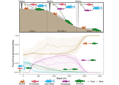
Ocean organisms transfer carbon via many natural processes from surface to seafloor. These include the passive sinking of carbon-rich particles and the active transport of carbon as animals swim downward. A recent study in GBC modeled how carbon stored in fish biomass moves from the sea surface to the seafloor in shelf–slope–abyssal systems through feeding interactions alone. This transport occurs as large fish eat smaller fish while occupying different vertical habitats in the water column. On average, this process delivers an amount equivalent to 5% of all carbon that reaches the seafloor—through sinking organic particles from phytoplankton and zooplankton. Yet, this can be as high as 20% in some shelf areas. On continental slopes, midwater fishes play a key role as a stepping-stone for carbon transfer (up to 50%) to the seafloor. Overall, the study reveals that the vertical movement of fish is an important pathway for delivering carbon to groundfish species, particularly on shelf areas where most commercially valuable fisheries operate.

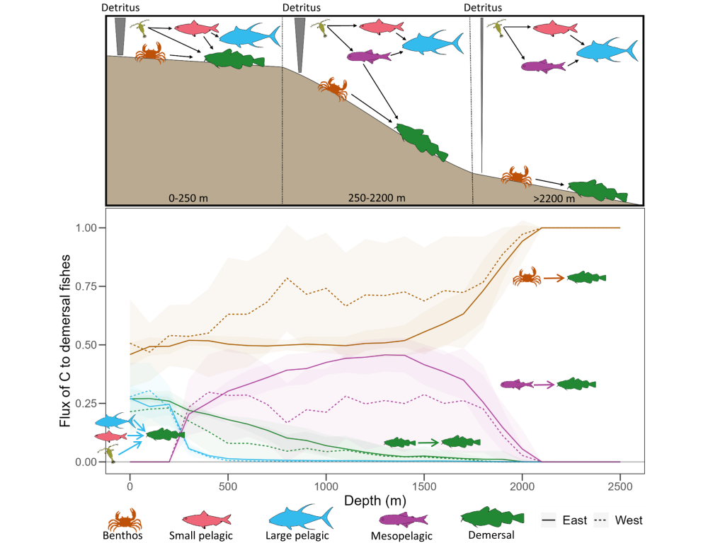
Caption: Schematic of a shelf-slope-abyssal system with hypothesized fluxes of carbon among major functional groups (top panel); and model-estimated fluxes of carbon from functional groups to demersal fishes (bottom panel). Solid and dotted lines are mean fluxes for Eastern and Western North Atlantic systems, respectively, and shaded areas are standard deviations. Values are proportional.


Authors

Daniel Ottmann (Technical University of Denmark (DTU-Aqua); Institute of Marine Sciences of Andalusia)
Ken H. Andersen (Technical University of Denmark (DTU-Aqua))
Yixin Zhao (Technical University of Denmark (DTU-Aqua))
Colleen M. Petrik (Scripps Institution of Oceanography)
Charles A. Stock (Scripps Institution of Oceanography)
Clive Trueman (University of Southampton)
P. Daniël van Denderen (Technical University of Denmark (DTU-Aqua))


Follow the authors:
bluesky: @danielottmann.bsky.social; @kenandersen.bsky.social
LinkedIn accounts: Ottman; Andersen; Truman
X: @daniel_ottmann; @69kno; @OceanLifeCenter; @van_denderen; @clivetrue;


Active Transport of Carbon to Demersal Fish Communities in Shelf-Slope-Abyssal Systems of the North Atlantic Ocean
Global Biogeochemical Cycles, Vol 40:2, e2025GB008861. https://doi.org/10.1029/2025GB008861

Applications for the SOLAS Summer School 2026 are open!

Posted by mmaheigan 
· Tuesday, July 15th, 2025 

The SOLAS Summer School is a regular, international event with the goal to provide the multidisciplinary air-sea interaction background to the next generation of Earth System scientists. We are proud to celebrate the 10th SOLAS Summer School, with an expanded immersive three-week programme designed for early career researchers. Participants will explore the complex interactions between the ocean, atmosphere, and climate through a dynamic blend of lectures, hands-on practicals, collaborative student-led projects, all aligned with the SOLAS 3.0 framework “SOLAS Science Towards Solutions.”

SOLAS Summer School 2026 will take place from 9-27 March 2026 at Centro Nacional de Pesquisa e Conservação da Biodiversidade Marinha do Nordeste (CEPENE) in Tamandaré, Pernambuco (PE), Brazil.

To apply for Summer School 2026, please submit your application here by 31 August 2025. For students without access to Google Forms please download the form and email your application to solasschool@xmu.edu.cn.

Please send an email to solasschool@xmu.edu.cn, if you have any questions or need further assistance regarding the Summer School.


Now available from BCO-DMO: Time series water sample data from four OOI arrays

Posted by mmaheigan 
· Wednesday, April 30th, 2025 

The Ocean Observatories Initiative (OOI) is a science-driven ocean observing network that delivers real-time data from multiple coastal and open-ocean arrays to address critical science questions regarding the world’s oceans. During each array service cruise OOI performs hydrographic sampling to evaluate and validate the deployed instrumentation. Service cruises are conducted annually for the open ocean arrays and every six months for the coastal arrays.  This repeat sampling has created time series of valuable physical, chemical, and biological information. Water samples from Niskin bottles on CTD casts are analyzed either on the ship or in onshore labs to measure oxygen, salinity, nutrients (nitrate, nitrite, silicate, phosphate, ammonium), chlorophyll, and the carbon system (pH, dissolved inorganic carbon, total alkalinity).

FIGURE 1

OOI launched a collaboration in 2023 with the Biological & Chemical Oceanography Data Management Office (BCO-DMO) to make OOI water sampling data available via the BCO-DMO website and ERDDAP server. BCO-DMO curates publicly available research-ready oceanographic data in accordance with FAIR data principles. Advantages of distributing OOI data through BCO-DMO include concatenation of the cruise-by-cruise data into a single dataset with a Digital Object Identifier (DOI) and provisioning through ERDDAP, which provides both human and machine-to-machine interfaces. The BCO-DMO Dataset pages include descriptions of sampling and processing methods, and README  files for each cruise.

Currently BCO-DMO has data from the OOI Station Papa Array (Gulf of Alaska, annual cruises over 11 years), Irminger Sea Array (North Atlantic, 10 years), Southern Ocean Array (SW of Chile, 6 years) and Argentine Basin Array (South Atlantic, 4 years). You can access the datasets via this direct link or from the BCO-DMO home page: Click on Projects, then search for “OOI Discrete CTD and Water Sampling Cruise Data”.

FIGURE 2

Figures 1 and 2 provide an example of the concatenated datasets using 10 years of data from the Irminger Sea Array. A Python script (implemented in a Jupyter Notebook available in https://github.com/WHOIGit/ooi-on-bco-dmo ) was used to access the data from the BCO-DMO ERDDAP server, extract variables of interest, apply available quality control (QC) flags, and visualize the data.  Figure 1 shows profiles of selected variables for successive cruises to give a sense of the depth-time data coverage. Note that the sample depths are relatively sparse since the OOI sampling goal is to validate instruments on the moorings rather than collect comprehensive profile data. Figure 2 represents profile variability over time by an overplot color-coded by year.

Even though constrained to “Acceptable” QC flags, some of the values plotted appear to be outliers, indicating the need for the user to consider further data quality assessment. Note that Discrete README files within the BCO-DMO dataset and CTD Cast Logs on OOI’s Raw Data Archive provide useful information. For example, the low values of oxygen in 2021are noted as inconsistent with oxygen from the CTD cast, whereas the high values of salinity in 2015 appear to be real, associated with a salinity maximum observed by the CTD. Since creating the Jupyter Notebook, data for two of the Irminger Sea cruises in OOI’s Raw Data Archive have been updated (including Nitrate for the 2021 cruise); these updates will be in the next version of the Irminger Sea dataset on BCO-DMO.

For additional Python scripts to explore OOI Discrete CTD and Water Sampling Cruise Data as distributed by BCO-DMO, for example to plot a discrete parameter against its corresponding CTD sensed parameter, see notebooks available in https://github.com/WHOIGit/ooi-on-bco-dmo/tree/main/notebooks .

Upcoming webinars

Posted by mmaheigan 
· Wednesday, December 4th, 2024 

Leaky Deltas webinar
Speakers: Gerrit Trapp-Müller ( SoMAS, Stony Brook University), Fei Da (Princeton University), Gabriella Akpah Yeboah (University of Ghana)
February 4, 10a eastern REGISTER


View all our webinars–upcoming and recordings

Northeast regional node

Posted by mmaheigan 
· Wednesday, December 4th, 2024 

Coming soon…

Join us at AGU Dec 14

Posted by mmaheigan 
· Wednesday, December 6th, 2023 

December 14, 2023 at 6:30 pm

OAIC Networking event during Fall AGU immediately following poster session Surface Ocean-Lower Atmosphere Study (SOLAS): 20 Years of Progress and Developments in Ocean-Atmosphere Science

Location: Shelby’s Rooftop Lounge, 250 4th St, San Francisco, CA

Fishing Vessel Ocean Observing Network (FVON) reimagines the global data collection paradigm

Posted by mmaheigan 
· Friday, December 1st, 2023 

With an increasingly wide variety of technology and innovations, from buoys to satellites, we now understand the open ocea n better than ever. Yet, existing technologies cannot cost-effectively provide accurate, up-to-date data on coastal and shelf ocean environments, especially beneath the surface. These dynamic regions impact billions of people in profound and varied ways.

Figure caption: Alongside other major global ocean observing technologies and networks, the Fishing Vessel Ocean Observing Network is built around the concept of “fishing for data” to collect high-quality ocean data such as temperature and salinity profiles. These measurements inform critical policy decisions, are integrated into sustainability efforts for fishers, scientists, and other relevant stakeholders, and can improve climate resiliency while protecting the health, well-being, and livelihoods of coastal communities and participants in the blue economy.

As described in a recent publication, the Fishing Vessel Ocean Observing Network (FVON) is reimagining the global data collection paradigm of coastal and shelf oceans by partnering with fishers and regional observation networks around the world. With more than four million fishing vessels worldwide, fishers cover much of the data-sparse nearshore ocean environments, vitally important regions of the ocean. By outfitting sensors onto vessels and on fishing gear, programs from New Zealand to Japan to New England, including researchers at WHOI, demonstrate that fishers can participate actively in the ongoing data revolution and eliminate critical oceanic data gaps without changing their standard fishing activities. Exponentially increasing the scale of data collection through fishing vessel and gear-based observations in nearshore marine environments has and will continue to democratize ocean observation, improve weather forecasting and ocean monitoring, and promote sustainable fishing while safeguarding lives and livelihoods. Already a proven concept regionally, FVON, alongside fishers and regional observation networks, will expand fishing-based observation to a global initiative.


Authors
Cooper Van Vranken (Ocean Data Network)
Julie Jakoboski (MetOcean Solutions, New Zealand)
John W. Carroll (Ocean Data Network)
Christopher Cusack (Environmental Defense Fund)
Patrick Gorringe (Swedish Meteorological and Hydrological Institute)
Naoki Hirose (Kyushu University, Japan)
James Manning (NOAA Northeast Fisheries Science Center (retired))
Michela Martinelli (National Research Council−Institute of Marine Biological Resources and Biotechnologies, Italy)
Pierluigi Penna (National Research Council−Institute of Marine Biological Resources and Biotechnologies, Italy)
Mathew Pickering (Environmental Defense Fund)
A. Miguel Piecho-Santos (Portuguese Institute for Sea and Atmosphere)
Moninya Roughan (University of New South Wales, Australia)
João de Souza (MetOcean Solutions, New Zealand)
Hassan Moustahfid (NOAA Integrated Ocean Observing System (IOOS))

Want to improve the spatiotemporal coverage of coastal water clarity? This approach combines high-resolution satellite data with low-cost in situ methods

Posted by mmaheigan 
· Friday, December 1st, 2023 

To maintain marine ecosystem health and human well-being, it is important to understand coastal water quality changes. Water clarity is a key­ component of water quality, which can be measured in situ by tools such as Secchi disks or by satellites with high spatial and temporal coverage. Coastal environments pose unique challenges to remote sensing, sometimes resulting in inaccurate estimates of water clarity.

Figure caption: Maps of model-corrected Landsat-8 derived Secchi depths from monthly clear sky images (2019–2021).

In this study, we couple low-cost in situ methods (Secchi disk depths) with open-access, high-resolution satellite (Landsat-8 and Sentinel-2) data to improve estimates of water clarity in a shallow, turbid lagoon in Virginia, USA. Our model allows the retrieval of water clarity data across an entire water body and when field measurements are unavailable. This approach can be implemented in dynamic coastal water bodies with limited in situ measurements (e.g., as part of routine water quality monitoring). This can improve our understanding of water clarity changes and their drivers to better predict how water quality may change in the future. Improved water clarity predictions can lead to better coastal ecosystem management and human well-being.

Figure caption: Workflow for obtaining Secchi disk depth with l2gen in NASA SeaDAS, bio-optical algorithms, and empirical adjustments.

Authors
Sarah E. Lang (University of Rhode Island’s Graduate School of Oceanography)
Kelly M.A. Luis (Jet Propulsion Laboratory, California Institute of Technology)
Scott C. Doney (University of Virginia)
Olivia Cronin-Golomb (University of Virginia)
Max C.N. Castorani (University of Virginia)


Twitter / Mastodon
@sarah_langsat8 on Twitter
@kelly_luis1 on Twitter
@scottdoney@universeodon.com on Mastodon
@ocronin_golomb on Twitter
@MaxCastorani on Twitter

International FAIR Data Workshop POSTPONED

Posted by mmaheigan 
· Tuesday, October 10th, 2023 

International Workshop: FAIR Data Practices for Ship-based Ocean Time Series

DATES POSTPONED

OVERVIEW: Sustained ocean time series measurements are fundamental to distinguish between natural and human-induced variability in ecosystems and processes required to advance ecological forecasting. The last international ship-based ocean time series workshop, held in November 2012 (Bermuda), focused on recommendations to improve data comparability. Over the past decade (see Fig.) the ocean observing community has contributed to numerous efforts and activities in support of building a global network of ocean time series with the aims of:

  • Elevating the visibility and utility of these observing assets for understanding climate-ecosystem links
  • Improving coordination, communication, and scientific synthesis products across ocean time series programs/sites
  • Building consensus on foundational components such as methods and FAIR data practices

This workshop on FAIR Data Practices for Ship-based Ocean Time Series will bring together globally distributed ship-based ocean time series representatives who are interested and committed to FAIR data practices with data managers and experts in semantic web technologies with the following objectives:

  • Share and vet newly drafted biogeochemical and biological use cases for adoption by the broader METS community
  • Work with participating time series representatives to implement these use cases for their time series programs
  • Co-develop best practices for responsible use of ocean time series datasets (as a contribution to the Ocean Best Practices System repository)
  • Share new findings and update recommendations on sampling and analytical protocols from the 2012 Bermuda Time Series Methods Workshop
  • Explore mechanisms (and identify champions!) for engaging broader stakeholders (managers, educators, etc.) in the use of ocean time series data sets
  • Start planning (and identify champions!) for an Ocean HackWeek for ocean time series data
Next Page »

FilterbyKeyword

abundance acidification additionality advection africa air-sea air-sea interactions algae alkalinity allometry ammonium AMO AMOC anoxic Antarctic Antarctica anthro impacts anthropogenic carbon anthropogenic impacts appendicularia aquaculture aquatic continuum aragonite saturation arctic Argo argon arsenic artificial seawater assumptions AT Atlantic atmospheric CO2 atmospheric nitrogen deposition authigenic carbonates autonomous platforms AUVs awb bacteria bathypelagic BATS BCG Argo benthic bgc argo bio-go-ship bio-optical bioavailability biogeochemical cycles biogeochemical models biogeochemistry Biological Essential Ocean Variables biological pump biomass biophysics bloom blue carbon bottom water boundary layer buffer capacity C14 CaCO3 calcification calcite carbon carbon-climate feedback carbon-sulfur coupling carbon 14 carbonate carbonate chemistry carbonate system carbon budget carbon cycle carbon dioxide carbon export carbon fluxes carbon sequestration carbon storage Caribbean CCA CCS changing marine chemistry changing marine ecosystems changing marine environments changing ocean chemistry chemical oceanographic data chemical speciation chemoautotroph chesapeake bay chl a chlorophyll circulation climate clouds CO2 CO3 coastal and estuarine coastal darkening coastal ocean cobalt Coccolithophores commercial community composition competition conservation cooling effect copepod copepods coral reefs cruise CTD currents cyclone daily cycles data data access data assimilation database data management data product data sets Data standards DCM dead zone decadal trends decomposers decomposition deep convection deep ocean deep sea coral denitrification dense water deoxygenation depth diatoms DIC diel migration diffusion dimethylsulfide dinoflagellate dinoflagellates discrete measurements distribution DOC DOM domoic acid DOP dust DVM ecology economics ecosystem management ecosystems eddy Education EEZ Ekman transport emissions ENSO enzyme equatorial current equatorial regions ESM estuarine and coastal carbon fluxes estuary euphotic zone eutrophication evolution export export fluxes export production extreme events faecal pellets fecal pellets filter feeders filtration rates fire fish Fish carbon fisheries fishing floats fluid dynamics fluorescence food webs forage fish forams freshening freshwater frontal zone functional role future oceans gelatinous zooplankton gene transfer geochemistry geoengineering geologic time GEOTRACES glaciers gliders global carbon budget global ocean global ocean models global overturning circulation global warming go-ship grazing greenhouse gas greenhouse gases Greenland ground truthing groundwater Gulf of Maine Gulf of Mexico Gulf Stream gyre harmful algal bloom high latitude human food human impact human well-being hurricane hydrogen hydrothermal hypoxia ice age iceberg ice cores ice cover industrial onset inland waters in situ inverse circulation ions iron iron fertilization iron limitation isotopes jellies katabatic winds kelvin waves krill kuroshio lab vs field land land-ocean continuum larvaceans lateral transport LGM lidar ligands light light attenuation lineage lipids low nutrient machine learning mangroves marine carbon cycle marine heatwave marine particles marine snowfall marshes mCDR mechanisms Mediterranean meltwater mesopelagic mesoscale mesoscale processes metagenome metals methane methods microbes microlayer microorganisms microplankton microplastics microscale microzooplankton midwater migration minerals mitigation mixed layer mixed layers mixing mixotrophs mixotrophy model modeling model validation mode water molecular diffusion MPT MRV multi-decade N2 n2o NAAMES NCP nearshore net community production net primary productivity new ocean state new technology Niskin bottle nitrate nitrogen nitrogen cycle nitrogen fixation nitrous oxide north atlantic north pacific North Sea NPP nuclear war nutricline nutrient budget nutrient cycles nutrient cycling nutrient limitation nutrients OA observations ocean-atmosphere ocean acidification ocean acidification data ocean alkalinity enhancement ocean carbon uptake and storage ocean color ocean modeling ocean observatories ocean warming ODZ oligotrophic omics OMZ open ocean optics organic particles oscillation outwelling overturning circulation oxidizing oxygen pacific paleoceanography PAR parameter optimization parasite particle flux particles partnerships pCO2 PDO peat pelagic PETM pH phenology phosphate phosphorus photosynthesis physical processes physiology phytoplankton PIC piezophilic piezotolerant plankton POC polar polar regions policy pollutants precipitation predation predator-prey predators prediction pressure primary productivity Prochlorococcus productivity prokaryotes proteins pteropods pycnocline python radioisotopes remineralization remote sensing repeat hydrography residence time resource management respiration resuspension rivers rocky shore Rossby waves Ross Sea ROV salinity salt marsh satellite scale seafloor seagrass sea ice sea level rise seasonal seasonal effects seasonality seasonal patterns seasonal trends sea spray seawater collection seaweed secchi sediments sensors sequestration shelf ocean shelf system shells ship-based observations shorelines siderophore silica silicate silicon cycle sinking sinking particles size SOCCOM soil carbon solubility pump southern ocean south pacific spatial covariations speciation SST state estimation stoichiometry subduction submesoscale subpolar subtropical sulfate surf surface surface ocean surface waters Synechococcus technology teleconnections temperate temperature temporal covariations thermocline thermodynamics thermohaline thorium tidal time time-series time of emergence titration top predators total alkalinity trace elements trace metals trait-based transfer efficiency transient features trawling Tris trophic transfer tropical turbulence twilight zone upper ocean upper water column upwelling US CLIVAR validation velocity gradient ventilation vertical flux vertical migration vertical transport warming water clarity water column water mass water quality waves weathering western boundary currents wetlands winter mixing zooplankton

Copyright © 2026 - OCB Project Office, Woods Hole Oceanographic Institution, 266 Woods Hole Rd, MS #25, Woods Hole, MA 02543 USA Phone: 508-289-2838  •  Fax: 508-457-2193  •  Email: ocb_news@us-ocb.org

link to nsflink to noaalink to WHOI

Funding for the Ocean Carbon & Biogeochemistry Project Office is provided by the National Science Foundation (NSF) and the National Aeronautics and Space Administration (NASA). The OCB Project Office is housed at the Woods Hole Oceanographic Institution.